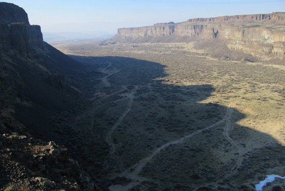
Photo: Looking down Frenchman Coulee from the start of this trip.
by Andy Dappen
There are times in the late fall, winter, and early spring when the trails of the high Cascades, as well as those throughout and the Wenatchee Valley, are a combination of snowy, rainy, and muddy. So what are trail enthusiasts to do at such times?
Answer: Look east to the Vantage advantage. Not only does the desert landscape around Vantage receive considerably less rain and snow than locales to the West, but the soils around here are sandier and rockier than those throughout the foothills of the Wenatchee Valley. After considerable rain or snowmelt, Vantage trails are simply wet and compacted, not muddy or sloppy.

Photo: Looking up Frenchman Coulee from a point that’s about a half-mile into the trek.
Furthermore, while the Vantage area is parched and desiccated during the heat of summer, for the shoulder seasons and even in the dead of winter there is much to enjoy here: coulees (canyons) carved by the ice-age floods and lined with rust-colored cliffs, dunes made from the sands of the massive pre-historic floods, hills of white silica deposits, pothole lakes, marshes in the drainages between lakes, spring wildflowers, and views from on high over the blue waters of the Columbia River.
Activity: Mountain biking, hiking, trail running.
Length: Big loop (v1 to v23 and back to start via v2 & v1) 16 miles.
Elevation Gain: Big Loop: 900 vertical feet.
Skill: 2+ (advanced intermediate). The route mainly follows old dirt roads and Jeep tracks so the technical difficulty of walking, running, or riding here is mainly easy with a few segments of intermediate terrain if mountain biking. What’s tricky is the route finding, there are no signs and many intersecting dirt roads.
Fitness: 2 (intermediate) for mountain bikers. 2+ to 3- (hard intermediate to easy advanced) for runners.
Access. From Interstate 90 take the Silica Road Exit that’s about 7.25 miles northeast of Vantage or 5.5 miles southwest of George. Follow Silica Road for 0.65 miles and turn left on Vantage Road. Follow Vantage Road about 0.65 then turn right and park in a small, primitive area where people often camp on weekends (no amenities). You can also park 2.65 miles after turning onto Vantage Road in a lower parking area that has pullout next to the dirt road going into Frenchman Coulee to the north and Echo Basin to the south (Discover Pass needed here).
Map: See our topo map below. Refer to this when reading the trip instructions below.
GPS. Because there is zero signage and a zillion crisscrossing roads (especially past waypoint v5), downloading our GPX file with the waypoints (blue diamonds) noted on our map will keep you on track. Without the waypoints, you’ll probably find yourself confused and misplaced at times. Worry not — it’s hard to get seriously lost. Should you need to it’s never that hard to bee-line to a base line like Silica Road and carry on from there.

Photo: Cabin Lake (frozen over in this picture). The detour to the lake is worthwhile.
Trip Instructions
- From the upper parking are (waypoint v1) follow a narrow road heading east that crosses the gut of Frenchman Coulee’s upper drainage, hooks around to the west, and then traverses talus slopes as it heads down into the floor of Frenchman Coulee. Reach the intersection a v2 after 1.6 miles, stay right, travel another 0.5 miles to v3 and stay right again.
- Ride 1.9 miles along Babcock Bench to v4 where a road comes in on your right. Go straight and carry on 0.9 miles to an intersection of dirt roads a v5. A paved road (Wanapum Drive) is just 150 yards past v5 but for this trip go right at v5 and start climbing. In 0.7 miles reach v6 and take a single-track trail splitting off to the right.
- The trail goes due south for 0.3 miles to v7 where it intersects a double-track road. Turn left and head east for 0.6 miles – much of the time there will be a fence on your left that you’re paralleling as you pass v8 to reach v9 at the intersection of Silica Road. Turn right on Silica Road (paved) and follow it for 0.55 miles before turning left on a large, wide gravel road at v10. Follow this major dirt road for 0.4 miles to v11 and turn right on a smaller gravel road.
- This smaller gravel road passes an interesting quarry at v12. It’s worth detouring (by going left) and checking out the excavating that’s taken place here. When ready, carry on to v13 (0.4 miles) and then you can parallel Silica Road on a gravel road for another 0.3 miles to v14. Here, go left on a dirt road leading away from Silica Road for 0.6 miles.
- At v15 the road bends to the right and heads east. Go straight through one intersection in about 0.1 miles and then in another 0.25 miles reach a T intersection at v16 with Road 2.5 SW (no signage).
- Waypoint v16 is a good place to detour (left) to checkout Cabin Lake. Upon returning to v16, however, head south for 0.45 miles to Silica Road (v17). At Silica Road, turn left and follow the pavement 0.95 miles to v18. Turn right off the pavement and go a few hundred yards on dirt road to Vantage Road. Cross the pavement here and follow the dirt road on the south side of Vantage Road 0.9 miles to v20 immediately before the high-tension power lines.
- Here a more difficult and adventurous route follows roads, trails, and cross-country walking to the sand dunes near Echo Basin via waypoints v21a, v21b, and v21c. This is interesting hiking and trail running. Mountain bikers will find more demanding riding along this route as well and will need to do some hike-a-bike getting down to the dunes and then over to waypoint v21d.
- For an easier, more straightforward completion of the loop go under the power lines and follow the dirt road another 0.75 miles to v21. Now, turn left on Vantage Road and follow the pavement 1.2 miles downhill to v22. Turn right and follow the dirt road several hundred yards to v23. Stay right here and go another 0.4 miles back to v2. You’ve been here before.
- Finish off the route by heading 1.6 miles up Frenchman Coulee back to v1. Mountain bikers are likely to find themselves pushing their bike up some of the loose rock coating the road on the upper portion of this final leg.

Photo: Dramatic light while riding along the floor of Frenchman Coulee.
Geology. Frenchman Coulee and Echo Basin (the adjacent coulee to the south) may be waterless now, but water – massive thundering cubic miles of water – carved these coulees during the Ice Age Floods (aka Missoula Floods). As many as 40 times between 15,000 and 12,000 years ago, Great-Lake bodies of water raged over this landscape as the ice dams confining huge lakes of meltwater stored in Montana occasionally failed. Then, over the period of few weeks, great walls of water moving at 60 miles per hour poured over these lands, and ripped open these channeled scablands occupying this part of the state. The coulees (drainages with horseshoe-shaped cliffs) and the many unusual pond-sized divots in the desert floor were sculpted with incredible rapidity. The culvert of Eastern Washington directed these great bodies of water emanating in Montana toward the Pacific Ocean.
Land Ownership. Predominantly state lands managed by Washington Department of Fish and Wildlife.
Permits. Discover Pass required for the lower parking area.
More Options. A mountain biking route along the Babcock Bench. Also, check the ‘Frenchman Coulee’ guidebook posts at this website if you’re a rock climber.
Leave It Better than You Found It. This should be every user’s goal. Do no damage and pick up trash left by others.
What some call cool country, others call coulee country.

Disclaimer. Treat this information as recommendations, not gospel. Conditions change and those contributing these reports are volunteers–they may make mistakes or not know all the issues affecting a route. You are responsible for yourself, your actions, and your safety. If you won’t accept that responsibility, you are prohibited from using our information.

