Attractions. It’s a lake of distinctions and surprises. It’s the longest natural lake in Okanogan County. It’s the largest saline lake in Washington State. It’s a tropical blue lake surrounded by a 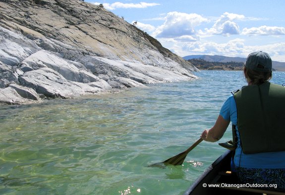 brown desert landscape. It’s a lake whose shorelines are virtually devoid of development yet one that is but a short drive from the town of Omak. It’s a lake whose salinity makes it tough on most life forms and yet monster Lahona cutthroat trout inhabit its depths. It’s a lake accessible to all boaters but, but one whose shoreline is off-limits to non-tribal visitors. Finally it’s a lake situated sixty miles from the nearest glacier yet one that was once smothered beneath and deepened by ice. For all of these reasons, Omak Lake is a fascinating one to paddle and fish.
Size. Omak Lake is eight miles long, two-thirds of a mile wide on average, and about 325 deep at its deepest point. To paddle around the complete perimeter of the lake is about an 18-mile jaunt, so it’s easy to make a day of paddling on the lake as long or as short as you want to.
Fitness: 1 to 3. Advanced fitness (3) to paddle the entire perimeter of the lake. A good trip of intermediate length (2) is a down-and-back trip down the eastern shoreline to the bay by Bull Pasture.
Allowed. Motor boats, paddle boats, swimming, and fishing are all allowed. Use of the shoreline outside of the access areas is prohibited.
Permits. Reservation Recreation Use Pass is required in each vehicle while boating, camping, hunting, fishing or group gathering on the Colville Indian Reservation. $80 annually $20 daily. An additional boat launch permit is required for motorized boats but not for canoes or kayaks. All permits can be purchased online here.
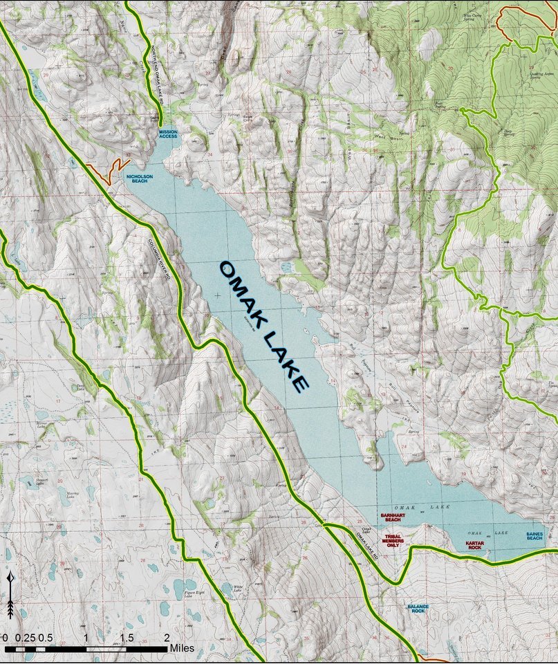
Map. See our attached maps.
Mission End Access. Head east of Omak on Highway 155 for 3.5 miles and then turn south (right) on North End Omak Lake Road and follow this 5.5 miles to its end at Mission Bay. There is a legal boat launch here and a swimming area. No permits are needed to launch boats or to park here for the day.
Nicholson Beach Access (aka Beer Can Beach). According to the Colville Tribe website, Nicholson Beach located on the northwest end of Omak Lake, also provides public access to the lake. Access the beach off the Columbia River Road. The website states the site is approximately 100 acres in size; has a quarter-mile of sandy beach; and can be used for swimming, boating, camping, and fishing.The boat launch here is best-suited to light craft.

Amenities are simple at the two access point listed above – there is no drinking water and no garbage service, but there are primitive outhouses. There are also a few primitive camping sites and a few picnic tables at the access areas.
Paddling Instructions. Head down the lake until you’re about half cooked and then paddle back to the start. The eastern shoreline of the lake, with its bays and glacially carved slabs bordering the lake make for the most interesting site seeing but for the sake of seeing the most scenery, we recommend going down one shoreline and returning along the other shoreline.
Other. Bring a camera, the lake with its aqua-blue hue and white-rock shoreline is extremely scenic. In summer be sure to mix things up a bit and swim as well – use the canoe as a swimming platform.
Shoreline Restrictions. The public is allowed to boat along the entire length of the lake but use of the shoreline for non-tribe members is restricted to the boat launch areas mentioned above.
Winds. The lake has a long fetch and on any given day strong winds can run down, up, and across the water and froth the surface into whitecaps. On a typical summer day it’s not unusual to have down lake winds (northerlies) in the morning and up lake winds (southerlies) in the afternoon as the day heats up. Even though visits to the shoreline are prohibited, if winds are threatening to swamp you, get ashore and wait out the blow – be respectful and do no damage to the shoreline.
Land Ownership. The entire lake is surrounded by property belonging to the Confederated Tribes of the Colville Reservation.
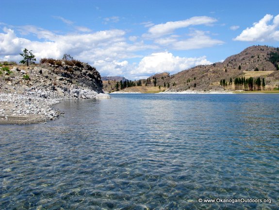 Geology, Topography, and Water Level. Most of the lake is surrounded by granite or gneiss that was originally cut by the Columbia River when lava flows once pushed and moved the river about. This trench was later scoured and deepened by the glaciers of the Pleistocene — check out the glacial scouring (grooves) left in the smooth rock slabs found at lake level. The lake was initially filled by ice left behind from receding glaciers. Now three small creeks flow into the lake but no creek drains the basin – which is why the water is saline. The lake level has dropped roughly 15 feet since 1900. The salinity of water is what causes the white deposit (sodium carbonate) on the rocks bordering the lake and what gives the water its smooth, soapy feel. An interesting side trip is to visit the Balance Rock (shown on the map), a huge glacial erratic that sits on a pedestal (the hard erratic has shielded the softer ground below it from eroding).
Fishing. The required tribal fishing license ($10/day, $20/3 days, $30/week, $40/year) to fish the lake is the bad news. The good news is that this license deters a lot of fishermen from fishing Omak Lake or elsewhere on the reservation and this greatly enhances the overall quality of fishing. Lahona cutthroats weighing 3 to 4 pounds are the average and fish weighing 8 pounds are not that rare. In spring (March 1 to May 31) Omak Lake has catch-and-release season and a variety of tackle restrictions designed to protect the fish and the fishery. Fly fishermen particularly enjoy fishing the lake and netting 24-inch fish is quite a thrill for them. As of June 1 there is a short season when fishermen can keep up to three fish per day, but only one of these fish can be over 18 inches in length. Here is detailed information, supplied by local fishing expert David Graybill, about how to fish the lake, tackle to use, seasons to be aware of, and where to obtain tribal licenses.
Also this is a helpful article about fishing the lake from The Spokesman Review published in May of 2014.
Additional Information: Colville Tribe Parks & Recreation 509-634-2200 ext 3145
Reporter and Date. Andy Dappen, 8/22/2014.
Leave It Better than You Found It. This should be every user’s goal. Do no damage and pick up trash left by others.
Disclaimer. Treat this information as recommendations, not gospel. Conditions change and those contributing these reports are volunteers–they may make mistakes or not know all the issues affecting a route. You are responsible for yourself, your actions, and your safety. If you won’t accept that responsibility, you are prohibited from using our information.