
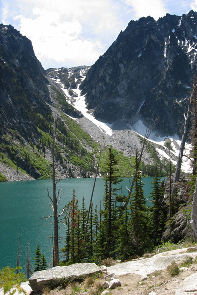
Many consider Colchuck Lake to be the prettiest alpine lake in the region. Obviously this is a subjective and debatable call, but anyone who isn’t wowed by this lake with its turquoise water and its neighboring rock walls should have their brain scanned because there is probably something wrong. Because Colchuck’s setting is so spectacular and because the hike into it is not overly difficult, this is one of more popular day hikes near Leavenworth.
Distance: 4.5 miles (one way).
Elevation Gain: 2,200 vertical feet.
Activity: hiking, trail running
Nearest Town: Leavenworth
Skill Level: 2 (intermediate)
Fitness Level: Hiking: 2 (intermediate). Trail Running: 3 (advanced).
Fees/Permits: Permit season for overnight trips to Colchuck Lake is mid-June until mid-October. Click here for details or call the Leavenworth Ranger Office ( 509-548-6977 ) to learn how to win a permit and/or how to pick one up on the day of your trip. A Northwest Forest Pass is also needed to park at the trailhead (day passes can be purchased at the trailhead). If you’re just taking a day trip into Colchuck, you don’t need to play the lottery game for a camping permit, but you still need to carry a self-issued wilderness permit picked up at the kiosk at the very start of the trail (free). More about permits.
Map: View our topo map (8.5’x11” portrait/landscape or 8.5”x14” portrait/landscape). Note: use ‘Print Preview’ before printing to properly scale this map to a full sheet of paper.
Access: Follow Highway 2 to Leavenworth and at west end of town turn south onto the Icicle Road, following signs to the Leavenworth National Fish Hatchery. Stay on the Icicle Road for about 8.6 miles. Near the Bridge Creek Campground, turn left onto Forest Service Road 7601 (The Eighmile Road). Follow Road 7601 for four miles to the Mountaineer Creek Trailhead. This is the starting point for both Colchuck Lake and Stuart Lake. A Northwest Forest Pass is needed to park here.
Trip Instructions.
- Leave the parking lot on the well-marked trail. The trail follows Mountaineer Creek for about a mile then crosses the the creek on a log footbridge. Now the trails starts climbing to a trail juntion at about the 2.5-mile mark.
- Go left (the right trail goes to Stuart Lake in another 2.5 miles). In a very short distance, you’ll recross the creek and then hop over boulders heading upstream. Then you’ll start climbing steadily again.
- About two switchbacking miles after the trail junction mentioned above you’ll reach Colchuck Lake with its beautiful blue water and it’s stunning views of Dragontail and Colchuck peaks.
- Once at the lake, a maze of smaller spur trails works counter-clockwise around the lake. Take a little bit of time to walk part way around the lake–you’ll find good viewpoints, pretty rock slabs to lounge on, swimming holes, and camping sites.
- Colchuck Lake is also one of the starting points for reaching the Enchantment Lakes via Aasgard Pass. To do this, work around the lake on a smaller path in a counterclockwise direction to reach the lake’s southeastern shores. Next follow a steep, cairned path in a southeasterly direction to the pass (noted as Colchuck Pass on many topo maps) at the 8,000-foot level.
Other Hikes. From the same trailhead there are two other hikes to consider in this area.
1) At the split in the trail 2.5 miles from the trailhead, the right fork of the trail leads to Lake Stuart. The hike to Lake Stuart is easier than the hike to Colchuck Lake because there is considerably less elevation gained.
2) One of the entrances to the Enchantment Lakes Basin is via Colchuck Lake. After reaching Colchuck Lake, hike counterclockwise on much smaller trails to the south end of the lake and find the cairned trail leading up to Aasgard Pass (aka Colchuck Pass). Aasgard is the highpoint of the Enchantment Lakes. See our topo map.
Dogs, Horses, Campfires are all prohibited at Colchuck Lake which is in the Enchanment Permit Area. Dogs and horses are also prohibited on the trails leading to Colchuck Lake at all times of the year. All forms of motorized travel are also prohibited on these trails.
Info and Conditions: This link from the Leavenworth Chamber of Commerce covers the details of the trip.You might find recent condition information at the Washington Trail Association — (WTA) trail report of this hike. Okanogan-Wenatchee National Forest: Wenatchee River Ranger District Leavenworth, 509-548-2550.
Leave It Better Than You Found It. This should be every outdoor user’s goal. Pick up trash left by others, pull some noxious weeds along your route, throw branches over unwanted spur trails, don’t ride or walk wet trails when you’re leaving ruts/footprints deeper than ¼ inch…
Disclaimer. Treat this information as recommendations, not gospel. Conditions change, and those contributing these reports are volunteers–they may make mistakes or may not know all the issues affecting a route.You are still completely responsible for your decisions, your actions, and your safety. If you can’t live with that, you are prohibited from using our information.
This guidebook post is sponsored by Northern Fruit Company located in East Wenatchee. Northern Fruit has been a steadfast supporter of WenOut since its inception in 2005. Northern Fruit appreciates and supports organizations that foster the physical well being of our community members along with a collective voice for our outdoor recreation community.

