
ATTRACTIONS. Located in the Lower Valley of the Wenatchee River, this 20-mile ride offers views of orchards, wineries, rivers and mountains. The uncrowded roads make this a good family outing as well as a popular training ride for cyclists living near Wenatchee.
DISTANCE. About 20 miles (round trip) from Confluence Park in Wenatchee. For a slightly shorter ride (15 miles) see the Monitor Short Loop from the Biking-Road guidebook.
ELEVATION. Rolling terrain with a number of short climbs.
SKILL. 1+ to 2- (strong beginner).
FITNESS. 1+ (between easy and intermediate).
ACCESS. Start from anywhere along the ‘Loop Trail.’ See the Loop Trail entry for access information to this trail. People living in Wenatchee who don’t want to drop down to the Loop can intersect the route as follows. Ride Western Avenue north. Western eventually curves to the right to become Maiden Lane. About 0.25 miles after this bend, turn left on Dawn Ave. Go 150 yards and turn right on Horse Lake Road. Go down the hill and at the light (main highway in and out of town), head north (turn left) on the sidewalk heading into the oncoming traffic. Cross the Wenatchee River riding against the oncoming traffic. Immediately across the bridge, fade left on the paved pedestrian trail and, in 30 or 40 yards, turn left on Chatam Hill Drive. Chatam Hill Drive becomes Lower Sunnyslope Rd. Follow the trip instructions below at the point that that route hits Chatam Hill Drive.
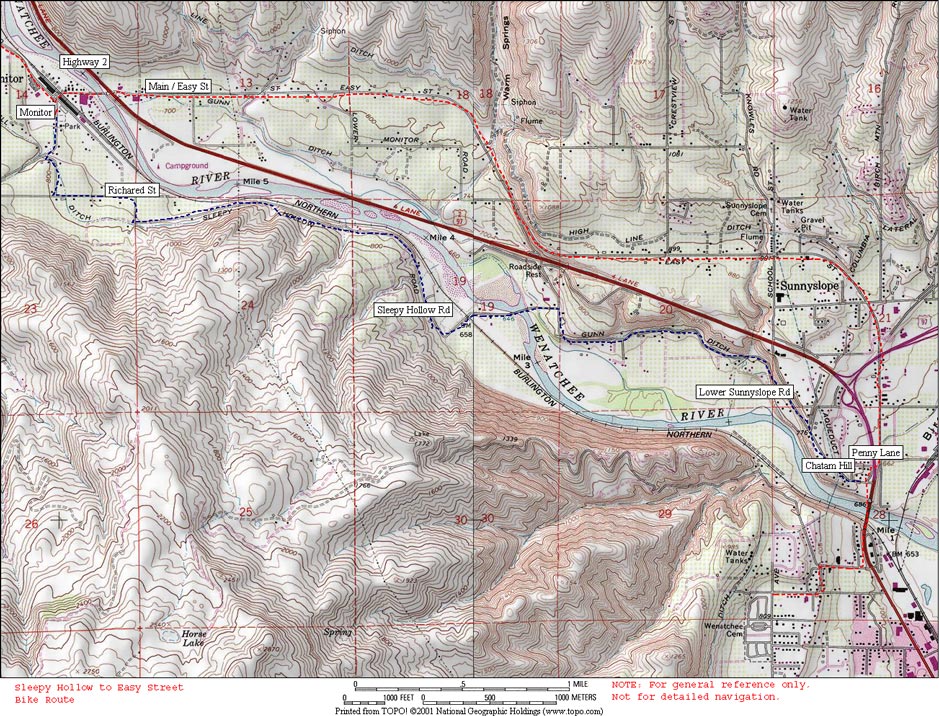
TRIP INSTRUCTIONS: (The distances quoted below are close but not exact).
- Follow The Loop to Confluence State Park, and follow the entrance/exit road out of the park.
- Turn left on Old Station Road and follow it about 0.25 miles.
- Turn right on Chester Kimm Rd and go a few hundred yards.
- Turn left on Penny Rd, cross Easy Street, and go under the freeway. On the other side of the freeway turn left on either Chatam Hill Drive or Cordell Ave–both merge with Lower Sunnyslope Road. Follow Lower Sunnyslope Rd for about 2 miles.
- Turn left on Sleepy Hollow Rd (if you hit the freeway you’ve gone 0.25 mile too far).
- Follow Sleepy Hollow Rd for about 3 winding miles. It eventually hooks right and becomes East Richared Rd.
- Follow East Richared Rd, for about 1.25 miles as it makes a few right angle bends and eventually comes to a stop sign with Fairview Canyon Road.
- Turn left and ride 0.3 miles uphill to Zager Rd.
- Turn right on Zager. In about 0.5 miles reach an intersection where Zager hooks right and Ayers Rd goes straight.
- Follow Ayers Rd as it climbs, traverses under the foothills, and then drops. After 1.75 miles reach an intersection with Old Monitor Road to your left and Pioneer Way to your right.
- To add an extra 3 miles (roundtrip) to the ride and a pleasant stop at the Anjou Bakery, turn left, follow Old Monitor Road, cross the wooden-planked bridge, then wind up to the bakery where Old Monitor Road hits Highway 2. After your carb/caffeine fix, retrace your steps 1.5 miles and turn onto Pioneer Way.
- Follow Pioneer Way about 0.4 miles to a stop sign in the town of Monitor. Turn left, cross the railroad tracks and follow Main Street a few hundred yards to the Intersection with Highway 2.
- Go straight across Highway 2 and follow Easy Street for 6 miles back to Wenatchee.
- Go through the first light (Highway 97) and at the second light (Penny Road) turn left.
- Reverse the early part of the ride back to Confluence Park. If you are a local who accessed the route via Western Avenue, turn right on Penny Rd, go under the freeway, and immediately turn left on Chatam Hill Drive.
RECOMMENDED SEASON. Spring, summer and fall. Even during the hot months this can be a pleasant ride in early morning or evening.
MAPS: See map below for more information. The Chamber of Commerce’s street map, ‘Discover the Wenatchee Valley’ is also excellent for orchard rides throughout the entire valley.
REPORTER: Andy Dappen (first posted 7/2005, converted to blog format 3/2010).
LEAVE IT BETTER THAN YOU FOUND IT. This should be every user’s goal. Pick up trash left by others, pull noxious weeds along your route, etc.
DISCLAIMER. Treat this information as recommendations, not gospel. Conditions change and those contributing these reports are volunteers–they may make mistakes or not know all the issues affecting a route. You are responsible for yourself, your actions, and your safety. If you won’t accept that responsibility, you are prohibited from using our information.