
Sarah Shaffer taking it all in on the ride through the orchards.
Attractions. Local cyclists often comment that they wished there were a cycling route between Wenatchee and Cashmere that kept them entirely off Highway 2. For such riders, we bring good news: Such a route exists. In fact there are two options—one that crosses the highway twice but does not follow it, and one that has no exposure to the highway at all (you cross under the highway once). There is a catch to one of these sans highway variations: The route is unpaved for a mile. This dirt road is very ridable on a road bike but it must be ridden more carefully, increases the odds of a flat, and adds another climb to the route. Nonetheless, cyclists who dislike the angst and noise of riding the shoulders of major highways will find these backroad linkages between Cashmere and Wenatchee welcomed additions to their repertoire of rides.
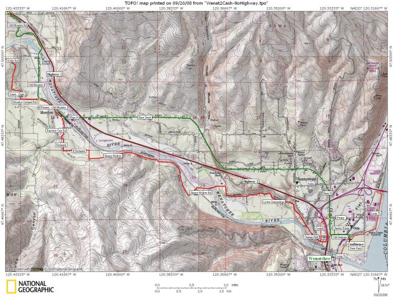
Distance. From Confluence State Park in Wenatchee, the round trip distance to downtown Cashmere using the red route one way and the green route on the return (see maps) is roughly 21 miles.

TRIP INSTRUCTIONS
-
Follow The Loop to Confluence State Park.
-
At Confluence, follow the entrance/exit road out of the park.
-
Left on Old Station Road. Go 0.45 miles.
-
Right on Chester Kim Road to avoid the traffic merge at the top of the ramp to Easy Street.
-
Left on Penny Street. Go under freeway and continue straight on Cordell Avenue which hits Chatam Hill Dr.
-
Right on Chatam Hill Drive, follow it uphill in a Northwesterly direction. It merges seamlessly with Lower Sunnyslope Road. Go roughly 1.75 miles.
-
Left on Sleepy Hollow Road (if you hit the freeway you’ve gone 0.25 mile too far). Go 2.75 winding miles until it terminates in a T intersection.
-
Left on East Richared Road. Go 0.45 miles.
-
Right on Richared Drive. Go 0.25 miles.
-
Right on Fairview Canyon Rd. Go 0.35 miles.
-
Left on Warehouse Road or Pioneer Way. Cross intersection in Monitor, staying on Pioneer and heading out of town in a NW direction. Go 0.45 miles to an intersection where Monitor Orchard Road branches off to the left. Two options from here.
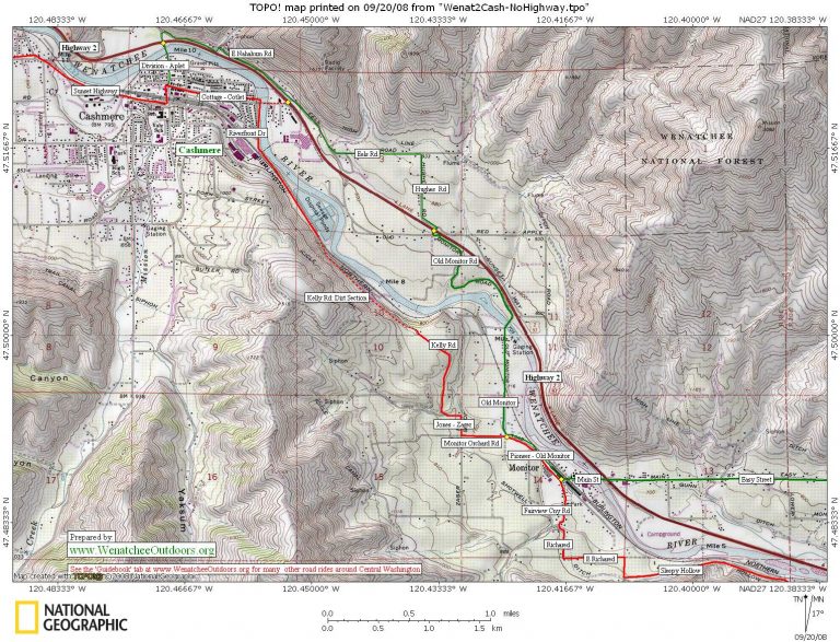
Option 1 (red route on map). Veer left on Monitor Orchard Road and go 0.3 miles. Turn right on Zager Rd, go a few hundred yards and the road then bends hard left, go a few hundred yards more. Turn right on Kelly Road (this is poorly signed, but if you go straight the road becomes Barden James Road). Follow Kelly Road uphill for 0.35 miles before it bends left and becomes a dirt road for 0.75 miles as it drops down toward the Wenatchee River. Near river level, Kelly Road becomes paved again and merges seamlessly with Riverfront Drive. Follow Riverfront Drive 2.5 miles. Turn left at Cottage Avenue (aka Cotlet Way) and ride 0.6 miles into downtown.
Option 2 (green route on map). Veer right on Pioneer which will become Old Monitor Road. Cross the wooden-planked bridge, then wind uphill. About 1.6 miles from the intersection, reach the Anjou Bakery where Old Monitor Road hits Highway 2 (the bakery is a popular stop for cyclists). Turn left on Highway 2 and go 1.3 miles. Turn left at the stoplight and head into Cashmere on Cottage Avenue (aka Cotlet Way). Go 0.7 miles to downtown.
Return Trip
- Return the way you came or ride Option 1 one way and Option 2 the other way. Strong riders may prefer using Option 1 for riding east (Cashmere to Wenatchee) because in this direction the dirt portion of Kelly Road is an uphill climb and they won’t need to ride the brakes as much when they head down the paved portion of Kelly Road. Weaker climbers may prefer riding Option 1 in a westerly direction and riding the brakes as they descend the dirt portion of Kelly Road.
- Back at Monitor there’s another variation for the return that keeps you from repeating your earlier route. Go left on Main Street and ride 0.25 mile out to Highway 2. Use the pedestrian bridge to cross the highway and then ride east on Main-Easy Street. Easy Street comes right back into the Old Station area of Wenatchee and intersects Penny Street at the second stoplight. From here, retrace the route back to Confluence State Park.
 Hazards. Most of this ride follows small frontage roads and orchard roads. The shoulders of many of these roads is narrow or non-existent, but the traffic is light.
Recommended Season. This ride and its variations are most enjoyable in spring when the orchards are in bloom, and autumn when pears and apples are ready to harvest. During the heat of summer, the ride is also pleasant in early morning.
Maps. Two maps cover this route (print both of these maps in landscape mode on 8.5″x11″ paper). See maps below.
Also, the Chamber of Commerce’s street map, ‘Discover the Wenatchee Valley’ is a good complement to orchard rides throughout the Wenatchee Valley.
Date: Route information prepared September 2008.
Note. This route was reconstructed from memory and maps so distances and road names may have slight errors. Please submit comments and corrections that will improve this route description for others.
Leave It Better Than You Found It: This should be every outdoor user’s goal. Pick up trash left by others, pull some noxious weeds along your route, throw branches over unwanted spur trails, don’t ride or walk wet trails when you’re leaving ruts/footprints deeper than ¼ inch…
Disclaimer. Treat this information as recommendations, not gospel. Conditions change and those contributing these reports are volunteers–they may make mistakes or not know all the issues affecting a route. You are responsible for yourself, your actions, and your safety. If you won’t accept that responsibility, you are prohibited from using our information.