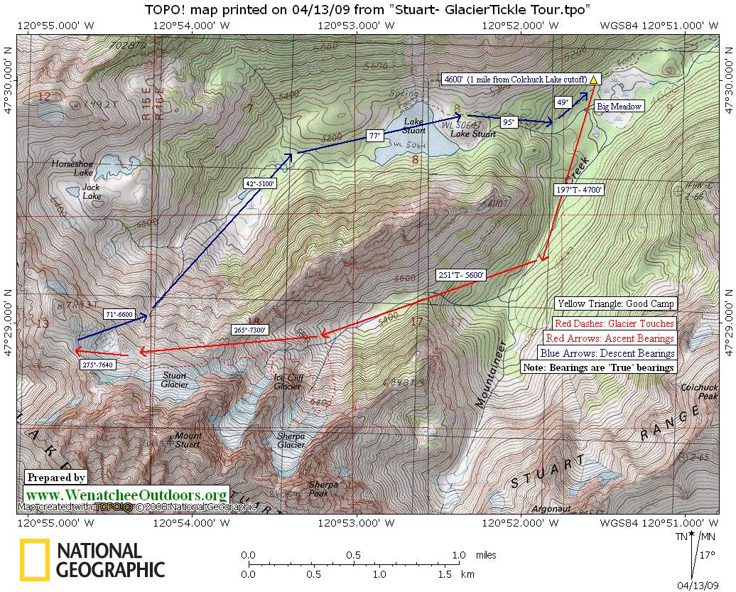

To keep an old passion burning, you need to keep viewing it with new eyes. That was Tom Janisch’s mindset as he sat on his throne, grabbed one of the guidebooks and maps kept within arm’s reach, and contemplated. Out went the waste and in came the inspiration for a tour tickling the toes of Stuart’s north-side glaciers.
By Saturday morning Tom had found another attention-deficit skier, who also believed that nothing was so tedious as a twice-told tale, and the two of us were walking the Eightmile Road holding high hopes for this new circuit through an old playground. At the end of the road, we skinned the trail toward Lake Stuart. Then, a mile beyond the Colchuck Lake cutoff, we split off cross-country, across deadfall, and across boulders, following the Mountaineer Creek drainage. It wouldn’t be Northwestern skiing without a sublime lashing of brush.
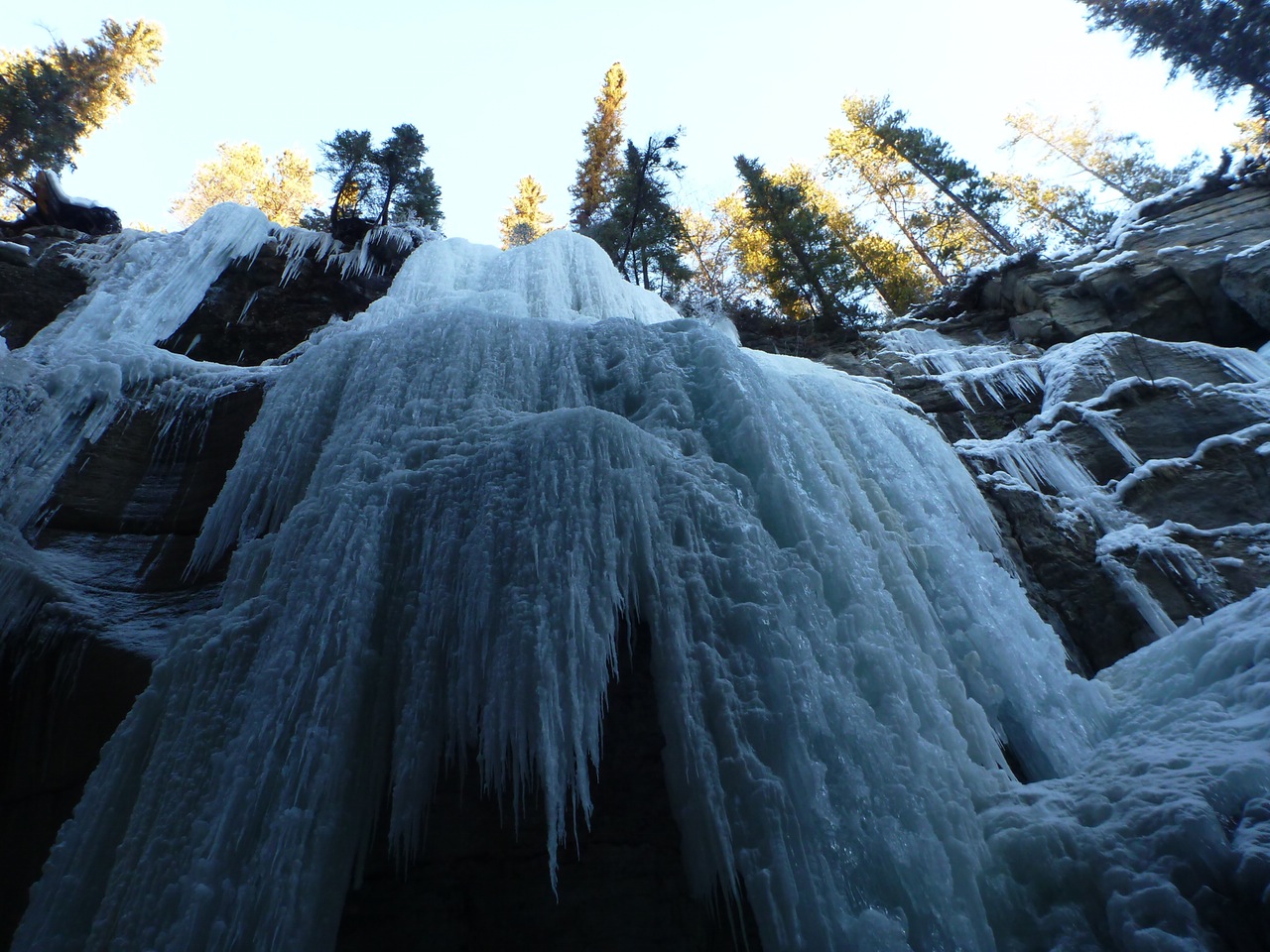
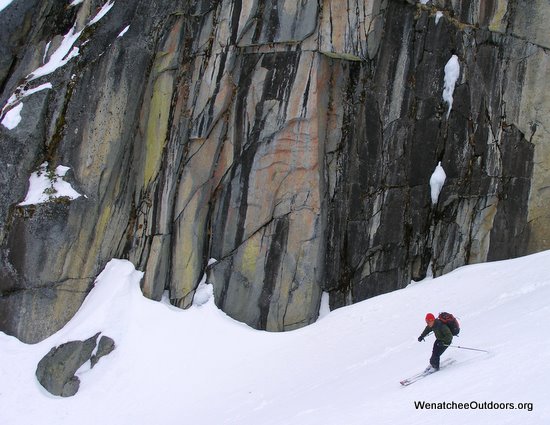
 By late morning, we were under the granite walls and glacial sheets composing the Sherpa-Stuart massif with necks cricked back, eyes squinted, and mouths agape. Earlier, these walls had basked in sunshine but now they were under the siege of buffeting winds and streaming clouds. Black ramparts, white snow, gray clouds… it was monochrome landscape save for the glowing blue glacial ice accenting the toes of the Sherpa and Ice Cliff glaciers.
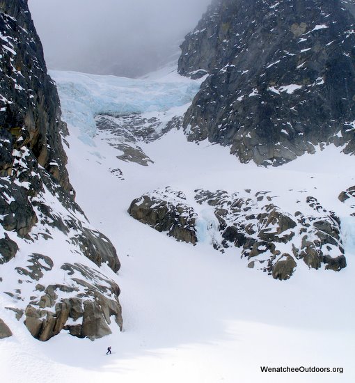
Up we went toward the terminal moraine of Sherpa. Unfortunately evening time constraints on my end didn’t afford the time to actually tag the ice of the present-day glacier. Instead, about 600 vertical feet shy of the lowest ice, we contoured away from the Sherpa. We sliced under the Ice Cliff Glacier, hoping in its excitement to see us it didn’t shower us with its blue blocks. Climbing in a westerly direction we then intersected the Stuart Glacier and tickled its toes before reaching Goat Pass (el. 7,640’).
Here, we ate and discussed how skiers of our ilk (chicken-skinned ones of mediocre athletic talent) could add variety to our touring passion without becoming overly enamored with the less-forgiving, steep slopes some of our friends use to spice-up their adventures. Baltasar Gracian gave us a slogan to hang our hats on, “A brand new mediocrity is thought of more than accustomed excellence.”
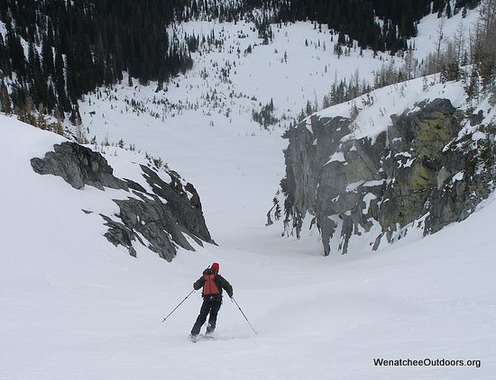
Mediocre or not, we enjoyed the windy, bitter, beauty of this route. And we enjoyed the descent. Because we had found no powder during the climb, it was no surprise our turns started on ice that resonated with the rasp of steel-wheeled skateboards rolling over concrete. Mysteriously, however, we glided into the Devil’s Deposition Triangle where flakes hijacked from everywhere else on the mountain were all being held hostage. We didn’t question, we simply skied this improbable stash for 1200 vertical feet.
The mysterious powder zone vanished as quickly as it had appeared. Once gone, we skied crusts, collapsing crusts, corn, and mush into the meadows west of Lake Stuart. Then began a 9.5-mile trudge back to the car along a route that’s downhill but littered with enough obstacles and short climbs to make you wonder how this freak of physics can be uphill in both directions.
I’d forgotten this annoyance but several minutes of sidestepping, gliding, and sidestepping had me remembering that nothing is so tedious as a tenth-time travelled trail. Looking at old places with new eyes does, in deed, keep the fire for ski touring alive. So does a bad memory.
Details, Details: Stuart – Glacier Tickle
 Attraction. A different way to travel through and enjoy a spectacular alpine setting. Rather than tagging different summits, tag different rivers of blue ice. Or simply cut under the toes of these glaciers and bag most of the same scenery with a little less exercise.
Activities. Do this as a ski tour, snowshoe or a summer mountaineering circuit.
Length: Roughly 22 miles roundtrip if starting from the Icicle River Road in winter or about 14 miles if doing the circuit once the Eightmile Road can be driven to the Mountaineer Creek Trailhead. The circuit can be done in a long push but is also a good overnight circuit if you camp by the Big Meadow.
Elevation Gain: 5,600 feet from the Icicle River Rd; 4,200 feet from the trailhead.
Fitness: 3+ to 4- (advanced plus) as a day tour; 2+ to 3 as an overnight tour.
Skill Level: 2+ to 3 (advanced intermediate to advanced)
Access. From Leavenworth, follow the Icicle River Road about 6 miles beyond the Sleeping Lady Resort. Park at the Bridge Creek Campground or at the end of plowing just past the Bridge Creek Campground (elevation 2,080’). No permits are needed in winter.
Trip Instructions
- Follow the Eightmile Road (FS Road 7601), which intersect the Icicle River Road at Bridge Creek. Cross Icicle Creek and head uphill for nearly four miles to the Mountaineer Creek Trailhead (el. 3,400’).
- Follow the trail toward Lake Stuart for about 3.25 miles (or 1 mile beyond the Colchuck Lake cutoff).
- At the high end of the Big Meadow (a good place to camp) follow up Mountaineer Creek drainage and then follow its northern fork to the 5600-foot level. From here, head generally west toward Goat Pass (el 7,640’), taking short jaunts up and down to the touch the different glaciers.
- Descend from Goat Pass in a generally northeasterly direction, as shown on our map, to ski the cleft shown in our slideshow. If worried about avalanche hazard, a safer route descends along a ridgelet just north of our illustrated route; at about 6,300 feet make a descending contour to the northwest into the creek basin below Jack Lake.
- Follow the meadows WSW of Lake Stuart to Lake Stuart, ski across the lake (or circle it in a clockwise direction if it’s no longer snow covered) and follow the trail about 4.3 miles back to the Eightmile Road.
Maps. Print our topo map below on 8.5”x11” paper in landscape mode.
Note: Use ‘Print Preview’ to properly orient and scale this map before printing.
Hazards. In winter, this route is exposed to avalanche hazard — some slopes can and do slide. Know how to assess the danger, when to stay off these slopes, and how to reduce the hazard through route selection. In summer, some of the snow slopes climbed or crossed can be icy and dangerous to unequipped travelers. Carry an ice axe and crampons.
Fees/Permits. None required in winter. Once the Eightmile Road opens, a Northwest Forest Pass is required to park at the trailhead.
More Info: See our guidebook info for accessing the Big Meadow.
Reporter: Andy Dappen, April 2009
Leave It Better Than You found It. This should be every user’s goal. Pick up trash left by others, pull noxious weeds along your route, disperse old fire rings, throw branches over unwanted spur trails…
Disclaimer. Treat this information as recommendations, not gospel. Conditions change and those contributing these reports are volunteers–they may make mistakes or not know all the issues affecting a route. You are responsible for yourself, your actions, and your safety. If you won’t accept that responsibility, you are prohibited from using our information.