This trail provides great views of the mountains bounding the upper Entiat Valley. It’s a unique opportunity to observe two important ecosystem processes in action–succession following a wildfire and an ongoing mountain pine beetle attack in lodgepole pine.
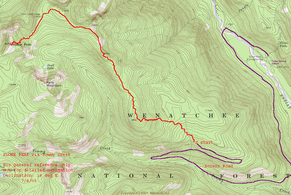
Maps: View our topo map below for more information. If needed, use map USGS 7.5- minute series: Silver Falls.
Note: use ‘Print Preview’ before printing to properly scale this map to a full sheet of paper.
Activity: Hiking
Nearest Town: Entiat
Skill Level: 2
Fitness Level: 2 — 2+ or 3- if doing this as a day trip.
Distance: 13 miles round trip
Elevation: 4480′ at the trailhead; 6820′ at Klone Pk; 2340′ gain
Recommended Season: Any time but fall (hunting season).
Access. From Entiat, proceed about 31 miles up the Entiat River. About 1 mile past Silver Falls Campground, turn left on the 5605 road. After crossing the Entiat River remain on the pavement as the road heads up the hill. About ½ mile from the North Tommy trailhead, the road turns to gravel but remains easily passable to passenger cars.
Trip Instructions. Follow the North Tommy trail, 1425. After gaining the ridgetop, a 1400 foot elevation gain, follow the ridge to Klone Peak. The trail is very obvious. Just past the south face of Klone, watch for a trail that switches back to the right. It leads to the top.
Cons/Hazards. The trail is rutted somewhat but not much worse than some non-motorized trails. Watch your footing on the armoured corners. On summer weekends, there can be considerable dirt bike traffic.
Uses Allowed: Motorcyclists, horse back riders, hikers, mountain bikers
Uses Not Allowed: Four-wheeled vehicles—jeeps and OHV quads.
Land Designation: Forest Service
Fees/Permits: NW Forest Pass
Trip Reporter: Matt and Lisa Dahlgreen 6-18-05
Leave It Better Than You Found It. This should be every outdoor user’s goal. Pick up trash left by others, pull some noxious weeds along your route, throw branches over unwanted spur trails, don’t ride or walk wet trails when you’re leaving ruts/footprints deeper than ¼ inch…
Disclaimer. Treat this information as recommendations, not gospel. Conditions change, and those contributing these reports are volunteers–they may make mistakes or may not know all the issues affecting a route. You are still completely responsible for your decisions, your actions, and your safety. If you can’t live with that, you are prohibited from using our information.