
Touring along Road 7230 brings you to multiple places where the view isn’t totally terrible.
Forest Road 7230 occupies the same general neck of the woods as the Tronsen Road near Blewett Pass. This road system, however, receives far less fanfare than the Tronsen Road yet gives Nordic skiers and snowshoers another interesting place to explore. From a snowshoeing stand point, the 3.75 mile trip to either Bojangle Ridge or to Tronsen Ridge is a simple and fairly gentle walk. Nordic skiers on lightweight cross-country skis will see the pitch of the road entirely differently and, especially on spring days when conditions could be icy, actually find the grade a little scary. Like many road systems in our mountains, cross-country skiers will find skinny skins extremely useful in lessening arm burn while headed uphill and in lessening body destruction once the skis are pointed downhill.
Maps. See our topo map below for more information.
Note: Use ‘Print Preview’ to orient/scale the map before printing.
Activity: Nordic Skiing, Snowshoeing.
Nearest Town: Blewett Pass
Distance / Elevation Gain. It is a 3.75 mile trip (one way) to Bojangle Ridge and the same distance but a few hundred more feet of elevation gain to Tronsen Ridge via Spur 217. Elevation gain is roughly 1500 feet.
Difficulty for Nordic Skiers: 2 (intermediate). The roads climb steadily and in good snow conditions can be handled fine by intermediate Nordic skiers. In difficult snow conditions (crusty or icy) the descent can be very fast and will require advanced skill or skinny skins to negotiate with lightweight skis and boots.
Difficulty for Snowshoers: 1 (beginner).
Access. From the Highway 2 / 97 junction (Y junction), drive Highway 97 south. About 1.2 miles from Blewett Pass, look for a small, unmarked pullout (large enough for a few cars) on the east side of Highway 97 at milepost 165.2 (elevation: 3,770 feet) Note: Tronsen Road (Rd 7240) is 0.4 miles south (uphill) of this access point. No permits or passes are needed to park here.
Trip Instructions.
- From the car, head 0.4 miles north (uphill) on the road to a gate across the road. Go around the gate and keep following the road as it hooks east now.
- The road keeps contouring as it climbs and comes to a fork 0.8 miles from the gate at Waypoint BJ2.
- Stay right and keep following the road another 1.7 miles as it continues to contour and climb to Waypoint BJ3.
- Here you can go straight and follow the main road another 0.75 miles to the communication station on Bojangle Ridge (nice views of Rainier, Stuart and the Enchantments from the end of the road). Or you can turn left on Spur 217 and climb 0.7 miles to the end of the spur. Go into the woods here and keep climbing and contouring. In about 200 yards, you’ll reach Tronsen Ridge. The ridge is forested but head north for a short distance and you’ll find some better viewpoints.
- Return trip. Nordic skiers on lightweight gear will probably want to retrace the ascent route. Snowshoers who climbed up to Tronsen Ridge might find it more interesting to walk north along the ridge for a quarter to a third of a mile and then drop straight down the fall line through south-facing forests to reconnect with Road 7230.
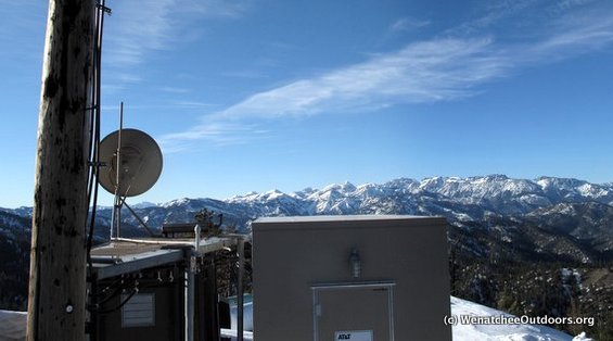
If you were a communication station, this wouldn’t be a shabby place to be located.
Hazards. This is a relatively safe road system. In a few places it does traverse across steep slopes that, theoretically, could be exposed to avalanches starting up higher. However, if the avalanche forecast for slopes between 4,000 and 5,000 feet is neither ‘high’ nor ‘extreme’, you can travel this road with a high degree of confidence that you are on safe ground.
Equipment. Most any type of snowshoe will suffice for this outing. For skiing, Nordic skiers can travel this road with general touring skis (roughly 50mm wide at the waist and lacking metal edges), but most skiers will be better able to contend with the wide array of snow conditions they might encounter if they use a metal-edged cross-country ski that is about 60mm wide at the waist. Regardless of the ski used, a no-wax base will make life easier. Skinny skins (1.25” to 1.5” wide) are also highly recommended for snow conditions requiring better grip on the ascent and/or for braking on the descent.
Land Ownership. Forest Service lands and roads.
Fees/Permits. No permits needed.
Trip Reporter and Date: Andy Dappen, February 3, 2012
Leave It Better than You Found It. This should be every user’s goal. Leave no litter and pick up trash found along the way.
Disclaimer. Treat this information as recommendations, not gospel. Conditions change and those contributing these reports are volunteers–they may make mistakes or not know all the issues affecting a route. You are responsible for yourself, your actions, and your safety. If you won’t accept that responsibility, you are prohibited from using our information.

