Photo: Cannon Mountain Couloir as seen from the bottom of the Eightmile Road.
by Andy Dappen
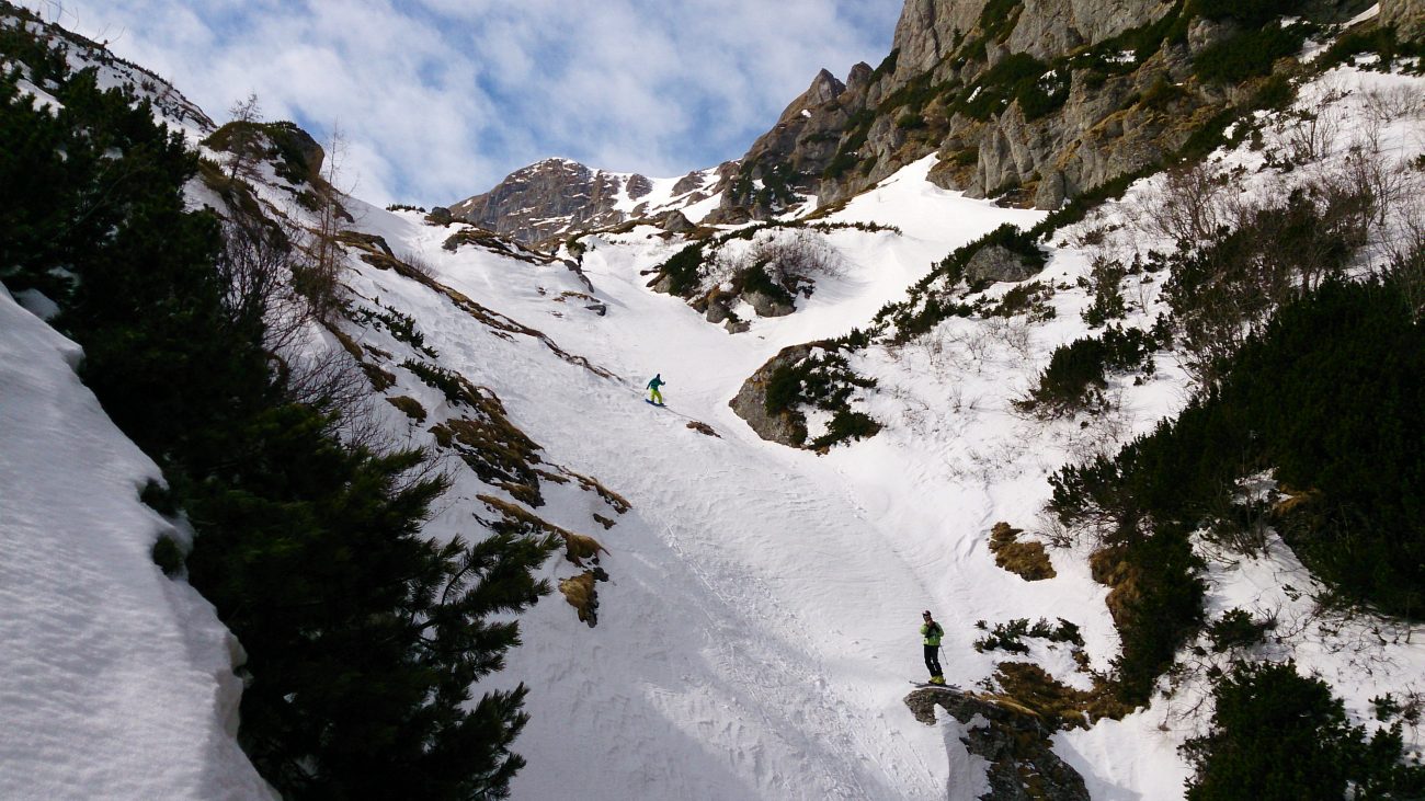
Now he’s finally at the other end of the spectacle – at the top looking steeply down the Cannon Mountain Couloir to the road 6000 vertical feet lower and thinking, “Why did I want to do this?”
The six-hour hoof from bottom to top has given him plenty of time to stew over uncomfortable questions: “Is this more than I’m ready for?” “Will the conditions be so firm as to cause a slide for life or so soft as to bury me under a Slurpee?” “Am I going to die today?”
By the time we reach the top, some of these questions have been answered. Jamie no longer needs to worry about getting caught in a slurry of sliding snow – the surface has been crampon hard. Whew — that only leaves sliding on ice and pinballing between the couloir’s rock walls to worry about.
We lounge at the top discussing whether we should wait for the snow to corn up or whether it has already softened enough to provide adequate edge bite. We throw snowballs and small rocks down the gulley to gauge the firmness of what awaits. Conditions are everything when it comes to skiing dangerous ground. If an inch of soft corn coats the surface, these slopes will be a picnic. Yet the same couloir can be a killing machine if the snow is rock hard and you lose an edge. As we stare down the gun barrel, Jamie mutters, “Gawd, if I kill myself, Polly’s gonna kill me?”
By modern standards what’s down there is actually quite passé. The 40-degree slopes we will descend look positively tame when stacked up against the 50- and 55-degree steeps that the big guns of the sport tackle. But to normal mortals like Jamie and me, where the occasional fall is not unusual, flirting with conditions where a fall will result in a death slide is only a good idea when we’ve grown overly weary of paying for college tuition.
Mike Rolfs and I are all for waiting an hour in hopes that the warming air will provide us with that picnic we’d like to ski. Jamie is of an altogether different mind because he knows exactly how his mind work. Sitting up here and fretting will only curtail his ability to actually ski. Intellectually he knows he can contend with the current conditions. For him, it will be better to get the job done without thinking about it too much, ”Jiminy Christmas,” he says with a voice that’s an octave too high, “if I wait here much longer my balls are going to disappear.”
 Photo: Jamie stepping into harms way.
He steps into his skis and then gingerly steps to the edge of the couloir and sideslips into the entrance gate that isn’t a whole lot wider than the skis themselves. With a combination of sidestepping and sideslipping he works past a chock stone pinching the upper gulley. It’s an obstacle that a hard man might just straight line past. Next, he starts a series of slow, deliberate stem christies. His skis chatter on a surface that’s more like frozen cookie dough than snow.
The turns aren’t pretty and his speed isn’t spectacular– Teton Mountain Gravity won’t use footage of this skiing for upcoming movies. Here where a fall is highly discouraged, however, his technique is smart and stable.

About a thousand vertical feet below the top, lower altitudes and higher sun exposure are magically alchemizing the snow. Over the course of several turns the skis stop chattering on frozen cookie dough and slice into creamy corn. Jamie switches from his jerky survival christies to smooth, carved turns. Grimaces turned to grins.
Onward we go. The steepness backs off, the slopes widen, the corn deepens. The intensity felt moments ago is washed clean by a wave of pure pleasure skiing.
 Photo: From cookie-dough snow to butter snow.
Some 2500 vertical feet from the top we’re either slightly drunk from this mountain hooch or feeling an emotional rebound called Rapture of the Steep. Jamie is giving us his commentary and can’t decide whether the awful first part of the ride or the wonderful second half of the game will be his overriding memory of the day. As is frequently the case, his ranching upbringing colors his language. “You’d have to threaten stringing me out for castration before I’d ski the top again today. The bottom half, however…. Wow! Wasn’t that like running a stallion through golden grass.”
Photo: Pure pleasure skiing.
Details, Details: Cannon Mountain Couloir
Activities: Ski touring.
Elevation Gain: 5,800 vertical feet.
Fitness: 3 (advanced).
Skill level: 3 (strong intermediate to advanced).
Access. From Leavenworth, follow the Icicle River Road about 6 miles beyond the Sleeping Lady Resort. Park in the plowed lot at the end of plowing near the Bridge Creek Campground (elevation 2,080’). No permits are needed to park in winter.
Winter Trip Instructions
- Follow the Eightmile Road (FS Road 7601), which intersect the Icicle River Road at Bridge Creek. Cross Icicle Creek and head uphill for 2.25 miles.
- At the 3,000 foot level (a half mile before reaching the Eightmile Lake Trailhead) you are nearly adjacent to Eightmile Creek and can access the creek easily. Leave the road and find a place to cross. In winter it’s not hard to boulder-hop across. Note: During the spring melt, crossing the creek is far more hazardous and complicated, so we recommend the ‘Spring Trip Instructions’.
- From the far side of the creek, head generally in a southerly direction up to the start of Cannon Mountain Couloir (el 7,800’). The bottom portion of this route has a lot of deadfall from the burn that ravaged these slopes. Our topo map shows one of the better ascent possibilities with relatively few fallen logs blocking the way.Descent Options. The northwest slopes offer many descent routes. A few are shown on our map. Many variations exist but a poorly chosen line will tangle you up down low in the blues of lots of deadfall. If you want to ski the couloir, be aware that some years the very top will be wind scoured and rocky. At such times you can descend on skier’s left about 100 vertical feet and contour in.
 Photo: The spring melt is too high here. Better to use the alternate approach described below.Spring Trip Instructions. If the Eightmile Creek is raging with meltwater, crossing as described above will not be feasible. In our own forays we’ve found the easiest (least amount of brush and deadfall) is to head up to the Mountaineer Creek Trailhead and follow the trail toward Colchuck and Stuart lakes some 300 yards. Before the first small creek the trail crosses on a tiny bridge made of thin logs, leave the trail and head uphill on a true bearing of about 107 degrees. The first 200 yards of this route has the densest trees, alder, and underbrush so don’t get discouraged by the very start. Follow purple arrows on our topo map (see below) for this route.
Other Route Beta. Many people who haven’t explored the northwest-facing slopes in the general area around the couloir are prone to use the old logging road shown on the map that traverses across these slopes and that is accessed from the parking lot at the Mountaineer Creek Trailhead. This is a bad route. The road is overgrown now and has lots of slide alder and vine maple to contend with (difficult with skis on). Furthermore when you get frustrated with the road, leave it, and try to bee-line upward you’re, in the worst part of the slope for terrible deadfall left from the old fires. The two routes described above take you up much more manageable portions of the slope.
Hazards. Avalanches can certainly sweep down these slopes, but the angle (low to mid 30 degrees), anchors, lower snow quantities, and wind protection all contribute in making these slopes moderately safe. The more persistent danger is a collision of the woody kind.
Maps. See our topo map below. (Print this map on 8” x11” paper in portrait mode).
Permits. None required before the Eightmile Road opens for the summer. If you try to ski this after the Eightmile Road opens in the late spring, you will need a Northwest Forest Pass to park at the Eightmile Lake Trailhead.
Reporter. Andy Dappen, April 29, 2012.
Leave It Better Than You Found It: This should be every outdoor user’s goal. Pick up trash left by others, pull some noxious weeds along your route, throw branches over unwanted spur trails, don’t ride or walk wet trails when you’re leaving ruts/footprints deeper than ¼ inch…
Disclaimer. Treat this information as recommendations, not gospel. Conditions change and those contributing these reports are volunteers–they may make mistakes or not know all the issues affecting a route. You are responsible for yourself, your actions, and your safety. If you won’t accept that responsibility, you are prohibited from using our information.

