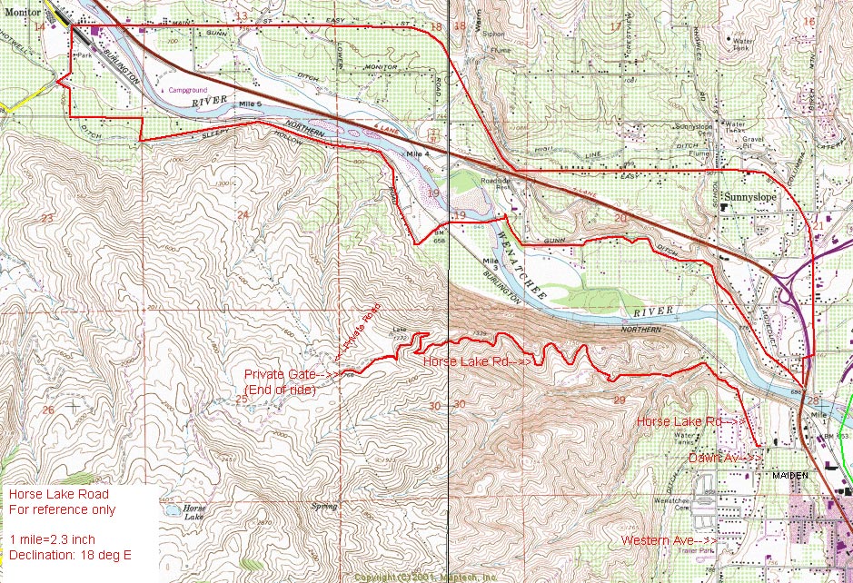
Horselake Road
 Typically, for a few weeks a year when a low snow level has settled in over the Wenatchee Valley, Horselake Road makes for an accessible and surprisingly nice Nordic skiing outing for Wenatchee residents. A one mile drive from WalMart (up Horselake Road) delivers you to the end of the pavement where the gravel portion of the road starts. No one is living up the road so the plowing stops where pavement end and a gate shortly beyond keeps vehicles off the road from late autumn until early spring. With our current snow pack, the road is in nice shape for cross-country skiing, winter walking, and snowshoeing.
You can ski or walk up the road 2.5 miles (the road climbs about 1,100 vertical feet) before the road is gated and enters the Horse Lake Reserve. The Horse Lake Reserve is owned by the Chelan Douglas Land Trust and the property here is closed from December 1 until April 1 to benefit mule deer that winter here.
Light no-wax skis typically work well on the road. The uphill is just that…uphill and sustained. Which makes the downhill fast and pretty sporty on lightweight Nordic gear. Currently there is unconsolidated snow on the edge of the road and it’s pretty easy for intermediate skiers to control their speed with some snowplowing and/or by using the softer snow to the side of any packed snow to scrub speed. In icy conditions the road gets quite sporty and skinny skins are useful to slow down the descent. Beginners who ski the road should expect some crashesn and, because the snow is rarely deep on the road, crashes may result in a few bruises (skinny skins would also be a good idea for beginners). Despite the possibility of taking some lumps descending, we think this is a fun route and a great one to grab during those short windows when low snows allow it.
Views along the road are pretty in most every direction. You’re likely find yourself thinking, “This is only two minutes outside of Wenatchee?” If skied in the early morning or early evening it’s not unusual to see lots of deer on the surrounding hills, hawks, rabbits, and/or coyotes. It can be like the Wild Kingdom out there.
The season for skiing this road is short—warmer temperatures will wipe out the thin snow pack quickly. Some days of freeze-thaw action will also turn the surface snow into a bobsled course that 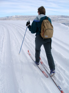 won’t be pretty for lightweight Nordic gear. On such days ponder your ski abilities and if you don’t have the skill to handle speed on skinny sticks, leave the skis in the car and enjoy wintertime walk instead.
DETAILS, DETAILS
February 2012 Update. The county has built a gate at the bottom of the road and is closing the road to vehicular traffic in the winter months when the road is soft and muddy. Kudos to the county for doing this. Extensive damage is done to the road each winter from 4-wheeling motorists and ‘mudders’ who purposely power up the road when it is so soft that deep ruts are inscribed in the road bed. These ruts greatly accelerate erosion, make the road unusable to normal vehicles come spring, and cost a great deal of money to re-grade.
Ownership: County Road
Access: Drive a mile up Horselake Road from Walmart and park where the pavement ends and the gravel starts. The road is wide enough here for turning around and parking.
Length: Gravel portion of the road is 2.5 miles one-way.
Elevation gain: 1,100 feet
Maps: View our topo map below for more information (8.5’x11” portrait/landscape or 8.5”x14” portrait/landscape).
Note: use ‘Print Preview’ before printing to properly scale this map to a full sheet of paper.
Difficulty: Intermediate skill needed for skiing on light Nordic gear. Easy on snowshoes or foot. Nordic skiers may want skinny skins to descend the road in icy conditions,. Or they shouldn’t be too proud to walk steeper sections of the road that might generate too much speed.
Season: A nice winter walk. For a short periods in the winter, the road might be snowshoed or skied. In spring, summer, or fall, use the road for mountain biking or running.
Permits: None needed. First Posted: 1/09/2008. Updated 2/09/2014
Leave It Better Than You found It: This should be every outdoor user’s goal. Pick up trash others have left behind and pull noxious weeds along your route.
IMPORTANT DISCLAIMER: Treat this information as recommendations, not gospel. Things change and those contributing these reports are volunteers–they may make mistakes, fail to give complete information, or may not know all the issues affecting a route. So forget about finger pointing: If things go wrong, you are completely responsible for yourself and your actions. If you can’t live with that, you are prohibited from using our information.