With such a dull name, you might fear a dull hike. But dull, the Black Lake hike is not. Using this gateway into the Pasayten Wilderness, you’ll ascend smoothly and gradually through (and here’s another creative name) the Lake Creek Valley to a deep, mile-long backcountry lake. With its sandy beaches and the dramatic Black Lake Ridge (gee, where did they come up with this name?) confining it. Black Lake is not only a surprise surpassing its boring name, it’s a worthy destination to get a taste of the vast Pasayten Wilderness.
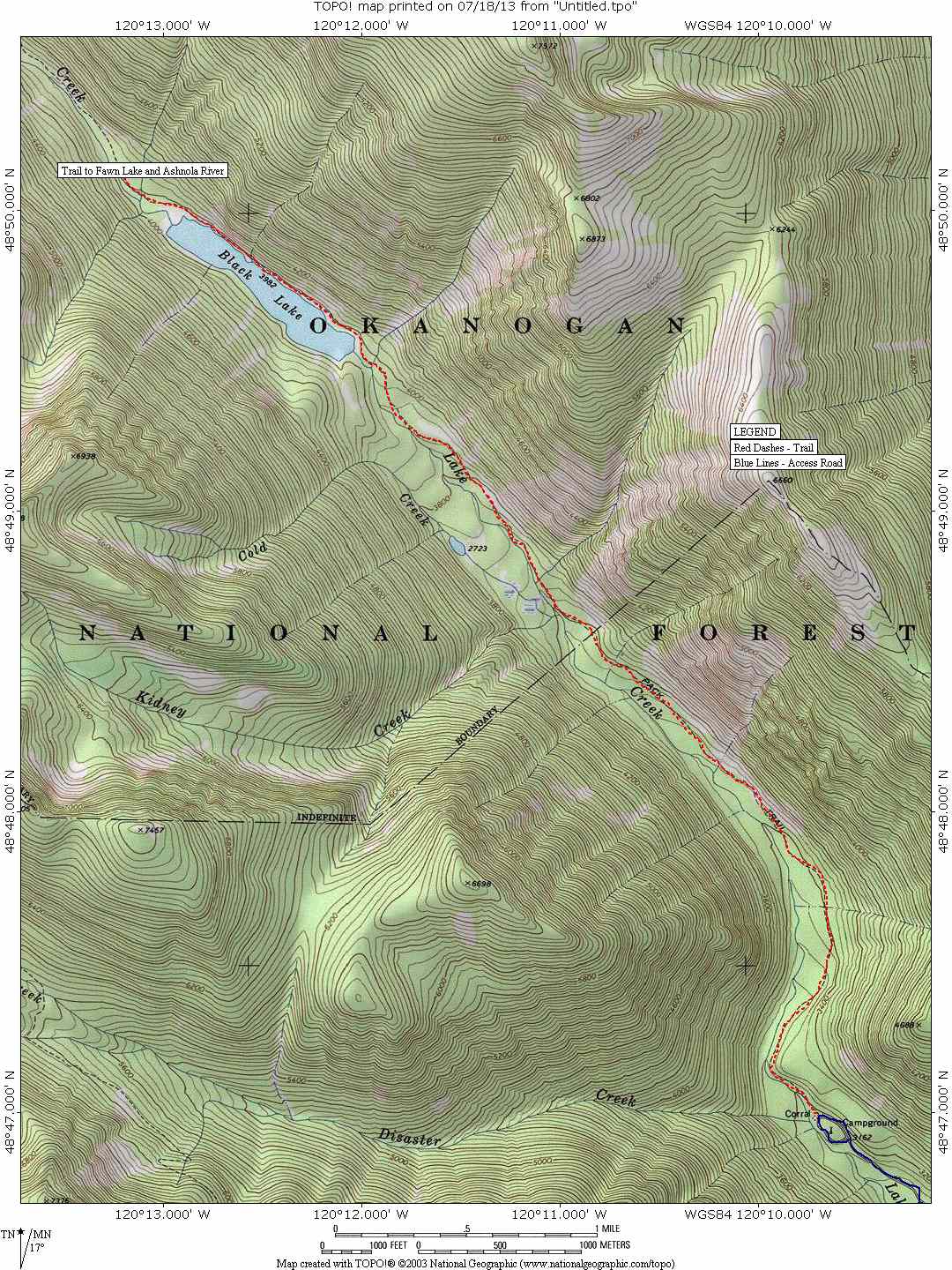
Maps. See our topo map. Note: Use ‘Print Preview’ to orient/scale the map before printing.
Activity: hiking, trail running, horseback riding.
Nearest Town: Winthrop.
Skill: 1 (beginner)
Fitness: 1+ to 2- (advanced beginner or easy intermediate)Distance: 8.5 miles.
Elevation Gain: 800 feet
Best Seasons. Generally this hike can be done as soon as early May, and all the way in to late October. In autumn wear bright colors — it’s a popular area for hunters.
Access. From Winthrop, drive west on Hwy 20 and turn right (north) onto West Chewuch River Road just on the edge of town (right before the baseball field). In 6.75 miles reach the junction with the East Chewuch River Road (which comes from Winthrop) and continue north, now on Forest Road 51. Follow this paved road for 14.5 miles and turn left onto FR Spur 100 (signed “Lake Creek Trail 2”). Drive 2.5 miles to road’s end at a corral and the trailhead (elevation: 3,200 feet).
Trip Instructions. Begin the trek ascending through a rare pocket of healthy forest untouched by flame. Don’t get too comfortable in the shade however, because within a half mile the trail enters a burn that scorched much of the land around here in 2003. In hot weather, you will be quite scorched, too, so pick cooler weather if possible. Now in the Pasayten Wilderness, wander through fireweed and tall brush and enjoy the sounds of bubbling Lake Creek. At exactly one mile, pass a house-sized boulder on your right that tumbled down the ridge in the spring of 1985 (there’s some trail trivia for you). Staying in much of the same type of terrain, you’ll cross many side creeks before reaching Black Lake’s sandy shores 4.2 miles from the start. Continue to the far end campsites if you wish, or simply sit in the sand, take a dip in the deep waters, or try to catch some Dolly Varden trout (of which there are many).
Allowed. Hikers and horses. This is the Pasayten Wilderness, so all forms of motorized/mechanized travel are prohibited. This includes mountain bikes.
Land Ownership. Okanogan National Forest.
Fees/Permits. A Northwest Forest Pass is required to park at the trailhead.
Trip Reporter: Matthew Tangeman, July 2013.
Leave It Better than You Found It. This should be every user’s goal. Do no damage and pick up trash left by others.
Disclaimer. Treat this information as recommendations, not gospel. Conditions change and those contributing these reports are volunteers–they may make mistakes or not know all the issues affecting a route. You are responsible for yourself, your actions, and your safety. If you won’t accept that responsibility, you are prohibited from using our information.