Although slightly out of our normal territory, the Yakima River is fed by upstream reservoirs and, in most years, can be canoed year round. So when our backyard rivers trickle out, the Yakima River, as if flows through a deep, entrenched canyon between Ellensburg and Yakima, provides a nice late-summer and autumn river to enjoy.
Length: 9 to 19 miles.
Difficulty: Class 1+ rapids. Obstacles along the way include log jams, sweepers, moderate current, and scattered minor rapids. The winds through the canyon are sometimes very strong and can affect progress and stability. Canoeists should have intermediate skills. Advanced beginners accompanied by intermediate paddlers should be fine as well.
Best seasons. Because this isn’t a backyard river for us here in the Wenatchee Valley, do this river in late summer or fall when our local paddling options are limited.
Water Level Info. Average April to August flows for the Yakima range between 3,100 and 3,600 cfs. The average flow for September is usually around 2,100 cfs, and November averages about 1,100 cfs. The river can be canoed at all these levels. Flow info can be obtained through USGS Water Resources—see river gauge 12484500 at Umtanum.
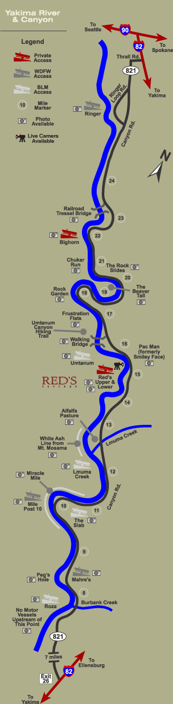
Map. Print this useful schematic map attached of the Yakima prepared by Red’s Fly Shop.
Access. Drive I-90 toward Ellensburg and take Exit 109 just south of Ellensburg. Drive Canyon Road (Highway 821) south toward Yakima.
Put-Ins and Take-Outs. Following are a few different places to put-in or/and take-out, listed in order of reaching them as you drive south on Canyon Road
- Drive 3.3 miles on Canyon Road and turn right on Ringer Loop Road and drive about 0.35 to a boat launch along the river. This put-in gives the longest paddle trip (19 miles to Roza Dam).
- If you drive another 8.5 miles downstream (south) of Ringer you can put-in or take-out at the BLM’s Umtanum Recreation Area. If taking out the exit is on river left just upstream of the suspension bridge.
- If you drive 10.25 miles south of Ringer you can put-in or take-out at the privately owned River View Campground.
- Roughly 13 miles and 18.5 miles south of Ringer are, respectively, the BLM’s Squaw Creek and Roza recreation areas, which can also be used as put-ins or take-outs. To drive to the take-out just upstream of the Roza Dam, turn right off Highway 821 and drive about 0.6 miles down to the river.
Trip Instructions. Decide on your put-in and take-out and go. There are a good number of riffles, small rapids, and log jams along the way but canoeists and kayakers who are paying attention can easily handle these on the fly.
Fishing. Over the past 20 years, catch-and-release regulations have turned the Yakima River into an extremely productive and popular trout stream. Fed by waters coming out of the Cascades, the Yakima has the cold, swift water trout like. There are also good hatches of caddis flies and stone flies that contribute to a strong fishery. More recently groups have been working to restore the salmon and steelhead runs on the river.
Additional Information: Read what Paddling Washington (Mountaineers Books, 2008) has to say about the Yakima River.
Hazards. The upper nine miles of this run in particular can have a lot of woody debris (logjams, sweepers). These obstacles are particularly dangerous to rafts and innertubes which are far less

maneuverable than canoes and kayaks. However canoeists and kayakers should take these hazards seriously—the newspaper article below from 2009 indicates there were obstacles of concern in 2009. Highway 821 parallels the river so, if in doubt, drive the river and scout it for hazards.
Condition Update. The article below comes from the Yakima Herald Republic:
August 23, 2009. YAKIMA — Rescuers pulled 39 people from the Yakima River on Friday evening after their giant, strung-together float of 18 rafts broke up and became trapped by three separate log jams. No one was injured even though several people went under the log jams. A Kittitas County Sheriff’s boat became disabled on one of the runs to the rafters and had to be rescued itself. A Yakima County River Rescue boat and a local resident, Doss Roberts, provided emergency assistance. The incident was a reminder, deputies said, that people shouldn’t begin their trip on the upper part of the river at KOA Campground below Umtanum Bridge. “The river area from the KOA campground to Ringer Road launch is extremely hazardous and conditions of the river change constantly,” said a news release Saturday from the sheriff’s marine unit. The three groups of rafts that became stuck were separated just enough so that attempts to physically reach each other were impossible, deputies said. The rafters were from Seattle, Auburn and Renton.
Leave It Better Than You Found It: This should be every outdoor user’s goal. Pick up trash left by others, pull some noxious weeds along your route, throw branches over unwanted spur trails, don’t ride or walk wet trails when you’re leaving ruts/footprints deeper than ¼ inch…
Disclaimer. Treat this information as recommendations, not gospel. Conditions change and those contributing these reports are volunteers–they may make mistakes or not know all the issues affecting a route. You are responsible for yourself, your actions, and your safety. If you won’t accept that responsibility, you are prohibited from using our information.
This post was originally published on 8/26/09.