The German was headed into the Pasayten Wilderness for several days of hiking; I was coming out after a blitzkrieg weekend of peak bagging. We stood alongside the trail comparing notes.
“You’ll have lots of peaks to walk up,” I told him, “Horseshoe , Armstrong, Arnold, Rock, Topaz, and Windy peaks. They’re all very pretty so do as many of them as you can.”
“Aber I’m no klimber only a valker,” he said in his thickly accented English.
“That’s OK, these are all hiking peaks. Maybe you’ll need your hands just a little to scramble, but these are all very easy to get up.”
“And how many of diese mountains half you klimbed?
“All six.”
A look of surprise flashed across his face as he stared at my scrawny toothpicks for legs. Then he smiled, “Making sex ist gute, ya?”
His misuse of German for English was comical, but what he was driving at was not lost in translation: Making it up six peaks on one fairly short trip is, indeed, good.
Whether you’re a hiker looking for the best views, a peak bagger wanting to knock off yet another of the Bulger Top 100 (Windy Peak), or a mountaineer looking to quickly boost your tally of summits for the year, this loop holds plenty of appeal. And while it’s fun loop in summer, it’s particularly appealing outing in late September and early October, when the larches become golden flames.
Details, Details: Windy Peak Loop (the Pasayten Six-Pack)
Trailhead Access and Trailhead Camping. From Loomis, follow the Loomis-Oroville Highway 2.2 miles north. Turn left on Toats Coulee Road (Road 39) and drive 13.6 miles (mainly uphill). Turn right onto Road 3900-500 and follow this rough, dirt road 5.7 miles to its end at the Iron Gate trailhead (high-clearance vehicles are recommended on this road). The trailhead has an unloading dock for horses, hitching posts, outhouses, picnic tables and a few camping sites (bring your own drinking water for camping). There is no charge for camping but a Northwest Forest Pass is required to park at the trailhead.
 Distance and Elevation. With all six peaks added to the itinerary, the total distance of the loop is 30 miles and the total elevation gain is 7,600 vertical feet.
Skill: 2 (intermediate) for hikers, 1+ (advance beginner) for mountaineers.
Fitness: 2 (if doing this in three or more days), 3 (advanced) as a weekend trip.
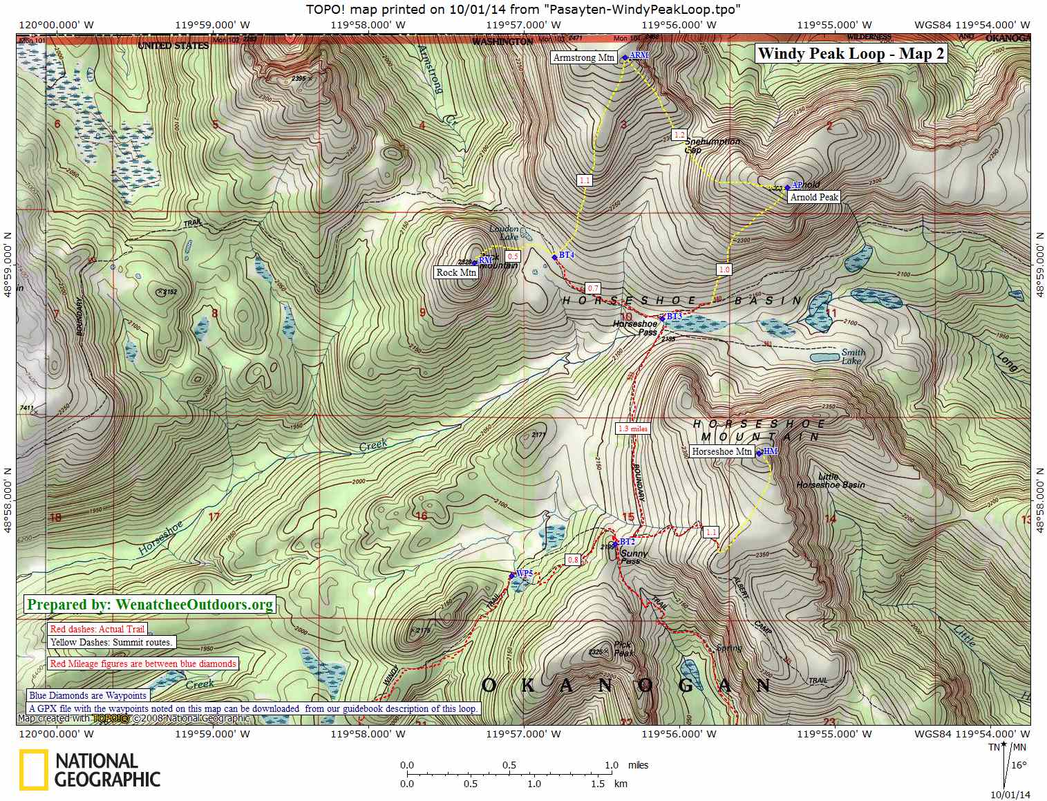
Maps: Map 1 (start), Map 2
Trip Instructions. From the Iron Gate trailhead, follow the Boundary Trail for 0.7 miles to waypoint BT1 and take a left of the Clutch Trail. Follow the Clutch Trail downhill for 1.1 miles to the stream at WP1 and then uphill for 3 miles to the trail intersection with the Windy Trail at WP2. Follow the Windy Trail for 2.5 miles to the summit of Windy Peak (WP3). From the summit, head cross-country down the northwestern slopes of the peak and re-find the main trail. Follow the trail to the trail intersection at WP4 and then take a 1.8-mile roundtrip jaunt up Topaz Mountain. Back at the trail intersection at WP4, go northeast on the Windy Trail for 3.5 miles to reach Sunny Pass (waypoint BT2). Here, take a left and follow the Boundary Trail 1.3 miles to Horseshoe Basin (a good place to camp). From Horseshoe Basin, head up Rock Mountain, Armstrong Mountain, and Arnold Peak. Return to the car via the Boundary Trail but, near Sunny Pass, take a sidetrip up the Albert Camp Trail to tag the summit of Horseshoe Mountain. Then return to the Boundary Trail and hike 5.5 miles from Sunny Pass back to the car at Iron Gate.
Direction and Camping. To do this as a weekend trip, we recommend going in over Windy Peak, hiking up Topaz Mountain, and then walking to Horseshoe Basin to camp. The next day, grab the summits of Rock, Armstrong and Arnold with a light pack before returning to camp and packing up. As you head back to the car via the Boundary Trail, dump the packs near Sunny Pass and dash up Horseshoe Mountain using the Albert Camp Trail. Finally, return to the packs and walk out to the car via the Boundary Trail.
Allowed. Hiking, trail running, and horseback riding. Dogs are allowed in the wilderness. Most of the route is in the Pasayten Wilderness, so motorized vehicles and mountain bikes are  prohibited.
Land Ownership: Most of the described route is in the Pasaytan Wilderness and is part of the Okanogan National Forest.
Leave It Better than You Found It. This should be every user’s goal. Do no damage and pick up trash left by others.
Disclaimer. Treat this information as recommendations, not gospel. Conditions change and those contributing these reports are volunteers–they may make mistakes or not know all the issues affecting a route. You are responsible for yourself, your actions, and your safety. If you won’t accept that responsibility, you are prohibited from using our information.
This post was originally published on 10/2/14.