
 Mountain’ would be a household name. But it’s not. Unlike its celebrity neighbor, Silver Star, Gardner has shied away from the spotlight and sits as a high, lonely outpost watching over the Methow Valley. Ascents of Gardner via its south slope are simple and can be done by the adventurous and enthusiastic hiker comfortable on steep terrain. Gardner Meadows, the fire-torched and avalanche-cleared slopes south of the peak, offer many comfortable campsites and make a perfect basecamp for the climb. Alas, little that is great is easily attained — a stay in the meadows first requires an up-and-down, ten-and-a-half mile march up the Wolf Creek Valley. Don’t despair, the wildflowers, the views from the mountain, and the real possibility of an evening concert sung by the local wolf pack make the trek worthwhile.
Maps. See our topo map. Note: Use ‘Print Preview’ to orient/scale the map before printing.
Activity: hiking, mountaineering.
Nearest Town: Winthrop.
Skill: 3 (for hikers), 1(for mountaineers).
Fitness: 3 (advanced).
Distance: 24 miles (round trip).
Elevation Gain: 5,800 vertical feet.
Best Seasons. June – October. Early summer, when the mountain is still snow covered, may be preferred by some parties looking to avoid the scree. If you go early, an ice axe and crampons are recommended. Winter ascents and ski tours on the peak have been done as well, but all approaches are long and avalanche prone.
Access. Head south through Winthrop along Highway 20. Shortly after crossing a small bridge, turn right onto Twin Lakes Road. After 1.3 miles, turn right onto Wolf Creek Road. After 2.8 miles on Wolf Creek Road, turn left onto Left Fork Wolf Creek Road. After 3.8 miles, the road forks. Veer left at the fork and continue another 0.6 miles to the Wolf Creek Trailhead and a large parking area (Northwest Forest Pass required at trailhead).
 Trip Instructions. Begin with the long hike of the Wolf Creek Trail. For the first 2 miles, the trail passes through many ups and downs. After crossing the North Fork at 2.3 miles (a difficult ford in early season), begin a more consistent ascent through dry, subalpine pine forest. After 8 miles, start climbing up hot, rocky slopes to reach the eastern fringes of Gardner Meadows (avoid spur trails which are generally unsigned and unmaintained). Reach the core of the meadows (trail’s end) and three wonderful campsites at 10.4 miles.
Gardner Mountain’s southern slope now looms overhead directly to the north. If the summit is your goal, leave the trail and, staying to the left of the streambed originating from the prominent gully, hike the steep meadows paralleling the stream. At 7100 feet, the meadows turn to rock and the slip-sliding ‘fun’ up scree begins. Head directly up the steep, rocky slopes, picking your way over scree and rock buttresses, and following the path of least resistance.
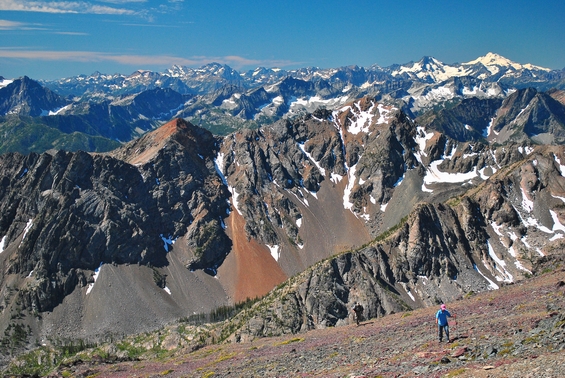
After enduring 1700 vertical feet of the one-step-forward-two-steps-back routine of climbing scree, reach a high plateau where the mountain’s wide and gentle summit sits on the ridge crest just to the right. Stroll on over and take a seat atop one of the North Cascade’s best view points. Besides seeing Mt. Rainier farther to the south, nearly all the major peaks of the North Cascades can be viewed from this vantage: Stuart, Maude, Glacier, Dome, Eldorado, Goode, Baker, Shuksan, Hozomeen….
You’ll also see twisted pieces of metal scattered around the top. These are the remains of a summit register that was struck by lightning and destroyed – a subtle reminder that this is not the place to be when the weather goes sideways.
Hazards. In winter, this route is exposed to avalanche hazard — some of these slopes can slide or be overrun by slides.
Allowed. Hikers and horses are allowed on the Wolf Creek Trail.
Land Ownership. Lake Chelan-Sawtooth Wilderness, Okanogan National Forest.
Fees/Permits. A Northwest Forest Pass is required to park at the trailhead.
Reporter. Matthew Tangeman, July 2013.
Leave It Better than You Found It. This should be every user’s goal. Do no damage and pick up trash left by others.
Disclaimer. Treat this information as recommendations, not gospel. Conditions change and those contributing these reports are volunteers–they may make mistakes or not know all the issues affecting a route. You are responsible for yourself, your actions, and your safety. If you won’t accept that responsibility, you are prohibited from using our information.
This post was originally published on 7/30/14.

