Image Lake Backpack
by Jim Brisbine
Sitting Bull Mtn (7789’)
Plummer Mtn (7870’)
September 15-18, 2017
Editors Note-Central Washington residents likely want to plan a slightly different route that intersects Jim Brisbine’s route by starting up the Chiwawa River Road at Trinity and going up to Buck Creek Pass and beyond, or by starting at the end of the White River Road and going up the White River and beyond.
 In mid-September, I checked off a long-overdue item on my mountain “bucket list” by backpacking into Image Lake. Somehow this famous destination had escaped me for many years, even when it seemed that anyone and everyone who owned a pair of hiking boots had been there at least once. As an illustration of Image Lake’s widespread renown, consider this tidbit: One of the books in my personal library is a coffee-table pictorial from Great Britain that honors the many, many mountain ranges around the world, and although only three of the 250-plus pages are devoted to our local Cascade
 Range, the cover is a full-width glossy photo of Glacier Peak rising above Image Lake. Talk about international stature! My golden opportunity recently presented itself when Eileen and Fay planned a five-day climbing trip to the Bannock Lakes area, entering via Suiattle Pass and exiting via Image Lake. It was decided that Fay would hike out on Day 5 of their trip, while I hiked in to meet Eileen with resupplies for an additional four days. Our tag-team plan actually worked, and we all had a wonderful time.
Day 1: I started at the Suiattle Trailhead on a mild, clear, Friday morning. Since this first day would involve quite a few miles on well-maintained trail, I opted to wear a semi-ancient pair of white leather Nike sneakers and to carry mountain boots on my pack. Such a strategy is often used by some climbers, but it was a new one for me. As things turned out, the sneakers were very comfortable and had a nostalgic “throw-back uniform” appearance, which probably amused some of the other trail hikers. Unfortunately, at their advanced age, the sneakers were not up to the task of backpacking; both soles came unglued somewhere around Mile 10.
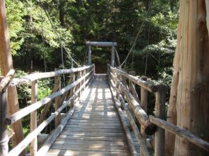
The Suiattle Trail is in excellent condition most of the way, and I was able to make rapid progress. A highlight of the trail is a suspension bridge over Canyon Creek around Mile 7. This modern-yet-rustic structure is a masterpiece of backcountry bridge design and construction.
In mid-afternoon, I encountered Fay hiking down the trail from Image Lake. I gave her a solo tent to use for her last night down the trail, and she gave me some information about Eileen’s whereabouts. Farther up the trail, the forest finally opened up and yielded scenic views across the grand Suiattle River valley.

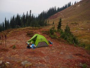
Shortly after 5:00pm, I arrived at Image Lake (7.4 hours from TH). The late-afternoon sun laid long shadows across the emerald water and surrounding hillslopes. I found Eileen relaxing on the opposite shore.
Eileen had a camp set up on the other (north) side of Miners Pass, so I got to see more of the lake basin as we hiked up to the pass. The vast, sweeping, verdant hillslopes of heather and delicate parsley-like vegetation were strikingly gorgeous, especially with their backdrop of rugged mountains. And, of course, Glacier Peak towered regally above all of the other mountains.

As we crossed over Miners Pass and descended to our camp in the meadow closely below, the northern view presented itself. This included StonehengeRidge, Dome Peak, Sinister Peak, and Bannock Mountain.
Off to the east, we could see the multiple pyramids of Sitting Bull Mountain—our goal for tomorrow.
Day 2: After enjoying yesterday’s clear air and long-range visibility, we were dismayed to awaken to a morning of heavy smoke. Apparently, the winds had  shifted overnight, and forest-fire smoke was now blowing in from the Pasayten Wilderness. Nonetheless, we loaded summit packs and headed down the Canyon Lake Trail.
After about 2.5 miles, the trail cut across the toe of West Sitting Bull Basin, and we veered off toward our objective peak. Steep heather slopes led us upward for about 1000 feet to a morainal bowl directly below the main and south peaks of Sitting Bull Mountain. We groveled up a steep, loose, scree gully to gain a high notch between the two peaks.

From the high notch, we made a short traverse over to a cleft in the cliff above us. Based on information provided by Fay, who had climbed Sitting Bull Mountain the year before, we knew that the face immediately left of the cleft was a feasible route. We roped up and used running belays up the rock face, placing several stoppers along the way. Although the face was well-broken with small ledges, most of the ledges were uncomfortably sloped downward and strewn with rubble, putting this part of the climb in a Class 4 category.
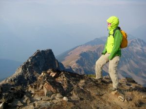
 Above the crux face, we unroped and scrambled Class 2-3 rock to the jagged summit (5.0 hours from camp).
The forest-fire smoke limited our views to nearby peaks, such as Plummer Mountain to the south.…and Agnes Mountain to the north. We found Fay’s register in the summit cairn and noted that nobody else had signed in since her climb in September 2016. It was no surprise that this somewhat remote and scrappy little peak is seldom climbed.
We descended by way of our up-route, being extra careful while down-climbing the Class 4 rock face. It was late afternoon when we reached our camp on Miners Ridge (4.5 hours from summit), so we hurriedly packed up and hiked back over Miners Pass. A few rays of evening sun poked through the smoky sky as we followed the trail around Image Lake Basin.
An hour of hiking took us to well-used Lady Camp, about 1.5 miles east of Image Lake. We erected our tent next to the trail and tried to imagine what Glacier Peak would look like without the smokescreen in front.
Day 3:We awoke to more heavy smoke to the south and west, but patches of blue sky to the east. Our goal for the morning was to climb Plummer Mountain, which stood closely to the northeast of camp. On our way toward the peak, we discovered that one of the amenities of Lady Camp is a red recliner lounge. No doubt this was left—either intentionally or not—by a horse packer. Perhaps a television will appear soon.
From Lady Camp, the easiest route up Plummer Mountain is to ascend grassy slopes in a northeasterly direction for 1000 feet until encountering the southeast ridge. This ridge leads up to the summit ridge, which comprises a half-dozen or more pinnacles.
The highest pinnacle involves a short Class 2-3 scramble to the summit (1.6 hours from camp). We found Fay’s register from last year and were surprised to see that only three people had signed in since then. The easy access and minor difficulties of this peak would suggest more summit traffic than six people in one full year.
Views were again restricted by the smoke, but the summit pyramid of nearby Sitting Bull Mountain was very visible and highly impressive.
 We returned to Lady Camp, packed up, and headed out at noon. Our exit route took us down switchbacks to Miners Cabin Trail, then eastward for 4.5 miles to intersect the Suiattle River Trail. The weather forecast called for rain starting in late morning, but the first drops held off until mid-afternoon and never really got too serious. We put 6 miles of wet river trail behind us before pulling into a roomy forest camp at 6:00pm, about 4 miles from the trailhead.
Day 4: After a night of fairly steady rain, we were pleased to awake to only light sprinkles. The final 4 miles of trail was a breeze in our lightweight sneakers. For my old white Nikes, which were headed directly to the trash can, it was a glorious ending to a long and proud career.
Approximate Stats: 46 miles traveled, 11,600 feet gained and lost (in four days).
Leave It Better Than You Found It. This should be every outdoor user’s goal. Pick up trash left by others, pull some noxious weeds along your route, throw branches over unwanted spur trails, don’t ride or walk wet trails when you’re leaving ruts/footprints deeper than ¼ inch…

Disclaimer. Treat this information as recommendations, not gospel. Conditions change, and those contributing these reports are volunteers–they may make mistakes or may not know all the issues affecting a route. You are still completely responsible for your decisions, your actions, and your safety. If you can’t live with that, you are prohibited from using our information.