Hay-Nahahum Divide
by Matthew Tangeman

In the checkerboard of private and public lands that lace the canyons north of Cashmere, finding a measurable hike without trespassing can be tricky. Fortunately, the trail to the Nahahum-Hay Divide accomplishes that task, allowing for a beautiful route to a unique foothills perspective. Gaining over 1000 feet in one mile, the trail makes for a great training hike for bigger adventures later on, and with extensive meadows and views, is still a worthy destination on it’s own. Once on the ridge, the area feels surprisingly remote. The town and highway are out of sight and sound, with nothing but mountain views (and some unfortunate power lines) piercing the horizon. While wandering the ridge north will soon hit private property, wandering the open, meadow-like south will put you on a beautiful perch high above Cashmere, a great place to sit and relax any time of year.
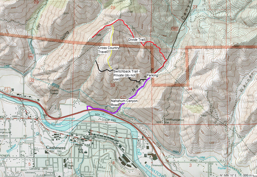
Maps. See our topo map. Note: Use ‘Print Preview’ to orient/scale the map before printing.
Activity: Hiking.
Nearest Town: Cashmere.
Skill: 2 – some route finding and basic map reading skills are necessary, which make the trip much more enjoyable.
Fitness: 2
Distance: 2.6 miles (round trip) to the ridge crest. You can walk a total of about 4 miles if you wander along the south ridge to where it drops off steeply.
Elevation Gain: Approx. 1400 feet.
Best Seasons. You can hike this route year-round but the flower season of springtime is particularly gorgeous.

Access. From Wenatchee, drive Highway 2 west until the Nahahum Canyon Road turnoff at the light just east of Milepost 111. Look for the Nahahum Canyon sign. Turn right onto the road, following it for exactly one mile (just past the Mile 1 marker), where there are a series of pullouts on the right side of the road, adjacent to an old quarry. Park here.
Trip Instructions. From the pullout, walk Nahahum Canyon Road north for 0.2 miles. Look for another pullout on the left next to an electrical box. The trail starts here. Immediately, the Divide Trail vaults up the hillside, giving you no room to warm up. Gain elevation quickly. At 0.75 miles, crest a sub ridge underneath power lines. At 0.9 miles, cross an old road grade. Continue straight across it – the trail becomes more distinct on the other side. Follow the trail until it reaches the Hay-Nahahum Divide on another old road at 1.3 miles. You can call it quits here, but for full value, wander south on the meadow-like ridge towards Cashmere. During spring, the balsamroot bloom here is enormous. Though there is no trail, the walking is flat and easy. Eventually, the few trees disperse and you’ll end on a grassy bluff high above Cashmere, just as the ridge begins to drop steeply downward. Soak up the view.
You may intersect a well-graded trail around here. This trail switchbacks steeply downward to Nahahum Canyon Road, near where you parked. The inclination may be to make a loop hike, but please don’t. Near the bottom of the canyon, the trail crosses private property that the landowners don’t want used. Because the actual private property boundary is indistinct, it’s best to simply stay off of the trail entirely to avoid conflict. Return the way you came.
Land Ownership. The described route is on Forest Service and BLM lands.
Leave It Better than You Found It. This should be every user’s goal. Do no damage and pick up trash left by others.
Disclaimer. Treat this information as recommendations, not gospel. Conditions change and those contributing these reports are volunteers–they may make mistakes or not know all the issues affecting a route. You are responsible for yourself, your actions, and your safety. If you won’t accept that responsibility, you are prohibited from using our information.
This post was originally published on 7/29/15.