
Attractions: The Magnet Creek area offers a variety of outings throughout the spring, summer, and fall. These trips yield expansive views of the complex hills surrounding Blewett Pass and follow undulating ridges that are lightly shaded by ponderosa pines and carpeted with verdant pine grass. Although ‘Magnet’ might imply this area attracts a lot of people, it’s quite the opposite. Even on a huge weekend (e.g., Labor Day) you’re likely to have the trips described below to yourself.

Distance: The best hike climbing Magnet Ridge to Tronsen Ridge can be 4.5 or 6 miles in length (roundtrip). There are also several loop possibilities that are roughly 15 miles, 12 miles, or 7 miles in length. The two longer loops are completed with the help of dirt and paved roads and might be best tackled by trail runners and mountain bikers. The shorter loop involves a few miles of cross-country travel and is best done by walkers with good navigation skills.
Elevation: The hike climbing along Magnet Ridge to Tronsen Ridge climbs 1,700 vertical feet.
Skill: 2+ (strong intermediate).
Fitness: 2 to 3 (intermediate to advanced) depending on the options chosen.
Activities. Hiking, trail running, a mixture of hiking and mountain bikes. Mountain bikers should consider the loop options mentioned below, which entail hiking a bike up to Tronsen Ridge and then riding. Descending Magnet Ridge on bikes is not recommended: 1) the trail is too steep, narrow, loose, for most riders 2) the lower half of the trail has many sharp switchbacks which were not designed for bikes and which need to be cut to be ridden (this is poor form when it comes to riding in a way that does not damage trails). Snowshoeing up Magnet Ridge to Tronsen Ridge could be an excellent outing for experienced winter travelers — the route is exposed to some avalanche hazard and we’re currently not sure where the nearest winter pullout for parking would be.
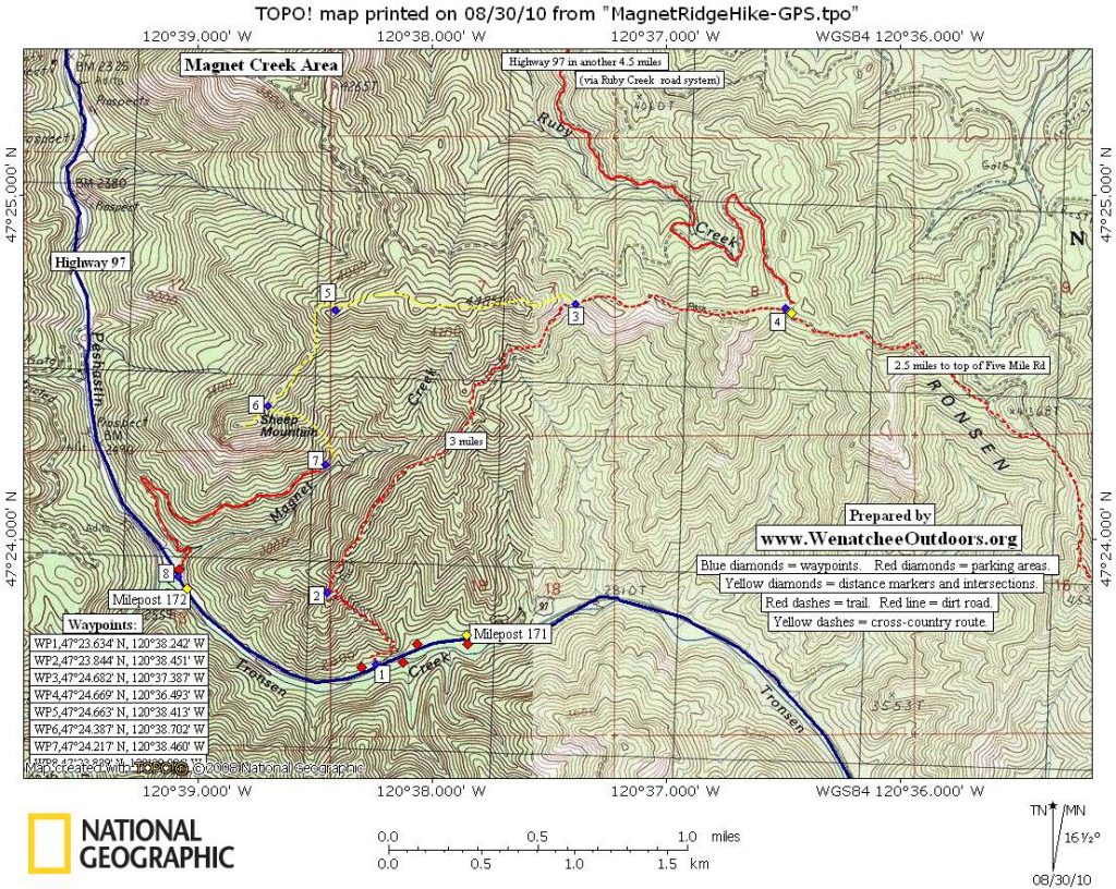
Access. From the Big Y Junction where Highway 2 and Highway 97 intersect, drive south on Highway 97 toward Blewett Pass for 13 miles. About 100 yards downhill of Milepost 172 there is a large pullout on the east side of the highway which is the parking for trip options using the Magnet Creek Road heading up Magnet Creek (see map). Another 0.7 miles up the highway (milepost 171.3) is where the trail leading to Magnet Ridge starts — use your odometer because there’s no formal trailhead and you will probably not see the trail’s beginning from the road. There’s a wider, grassy spot along the shoulder to park on east side of the highway about 30 yards downhill from where the trail begins but don’t pull a U-turn across the highway (it’s a dangerous place). Instead, go up to milepost 171 and use the wide pullover on the west side of the highway to turn around, and then drive back down the highway 0.3 miles. Alternately, you can park on the west side of the highway at milepost 171.2 in a wide spot along the shoulder (immediately across the highway from a rock outcrop) and walk 150 yards down the highway to the trail. Or park in the large pullout on the west side of the highway at milepost 171 and walk downhill 0.3 miles to the trail leading up Magnet Ridge. Note: There are no amenities at any of these places so take care of your bathroom needs before arriving and carry away all your trash.

Trip Instructions:
Option 1. The main attraction here is the trail up Magnet Ridge that ultimately intersects Tronsen Ridge. This trail has not been formally maintained for many years and has no established trailhead, yet it’s an easy trail to follow and, as of the summer of 2010, was in excellent shape. The main difficulty is simply getting started because the trail is grassy and indistinct at the highway. From the east side of the highway at milepost 171.3, walk perpendicular to the highway for 30 yards. The trail then fades to hiker’s left for about 50 yards before making a switchback to the right and traversing a few hundred yards to a southeast-facing ridgelet. Once on the ridgelet, the trail climbs nearly 800 vertical feet in a northwesterly direction and intersects the larger ridge system that confines Magnet Creek. Once on this larger ridge, what we’re calling Magnet Ridge, the trail heads northeasterly until it intersects Tronsen Ridge. It’s roughly 2.25 miles (one way) from Highway 97 to Waypoint 3 on the map, and then another 0.75 miles to Waypoint 4.
Option 2. Park in the pullout just downhill of milepost 172 and follow the Magnet Creek Road (a dirt road) about 1.25 miles until it ends. Hike steeply uphill (cross-country) in a northerly or a northwesterly direction until you reach the ridge northeast of Sheep Mountain. Turn right and follow this ridge, first going north and then heading east, until it intersects the Magnet Ridge Trail (Option 1 above) at Waypoint 3. Follow the Magnet Ridge Trail down to Highway 97, turn right, and then walk downhill along the highway about 0.75 miles to the start.
Maps: See our topo map.
Permits. None needed.
Trip Reporter. Andy Dappen, August 2010. Reposted May 22, 2014

Comments and Updates. Please leave updates to this post as comments below. We’re especially interested to know about this trip in winter (i.e., what did snowshoers think about this destination for winter travel and where could they safely park nearby?).
Leave It Better than You Found It. This should be every user’s goal. Pick up trash left by others, pull noxious weeds along your route, throw branches over unwanted spur trails, etc.
Disclaimer. Treat this information as recommendations, not gospel. Conditions change and those contributing these reports are volunteers–they may make mistakes or not know all the issues affecting a route. You are responsible for yourself, your actions, and your safety. If you won’t accept that responsibility, you are prohibited from using our information.