Winter Climb: North Buttress Couloir
By Lyndsay Mynatt
Tick lists: Admit it, we all have them. The North Buttress Couloir route up Colchuck Peak has been lurking in the back of my mind since last January when my husband and I searched for a non-skiing winter adventure. Dry conditions, low avalanche forecast, and an unquenchable thirst to be in the mountains provided plenty of reasons to get our first taste of winter mountaineering, but we missed the window of opportunity last year. The winter of 2015 starts with so little snow we can find no excuse not to attack the tick list. With no recent trip reports about this route, we launch into the icy unknown.The overall plan is to hike to Colchuck Lake, camp, then wake early to attempt the climb and return to the car. The trip begins with a four-mile walk up Eightmile 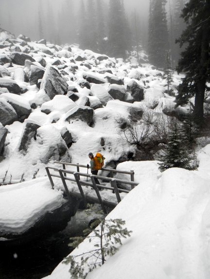 Road on compact snow. Given this low-snow year, we leave snowshoes in the car, gambling that the road will be packed the entire way. It is and we reach the Stuart Lake Trailhead in good time– four miles down and five to go.
Hiking along Mountaineers Creek is initially easy and the first few miles click by comfortably. Once we cross the bridge toward Colchuck Lake, our pace slows and my bag feels heavier with each step. The pack weight is reasonable, mine at 27 pounds and Jordan’s at 37, but the added road mileage has taken its toll. At 5:00 p.m. we reach our campsite on the shoulder of the frozen lake — nine miles in six hours, a personal worst. Tomorrow will be a longer day, so I’m worried about feeling this tired.
Light turns to dark in a matter of minutes as we establish a nomadic settlement. We set up our tent, find a nearby stream for water, and fire up the stove. After throwing on my puffy and getting hot water in my system, I am comfortable in this frozen environment. We fall asleep with flurries of cold snow enhancing the night sky.
At 4:30 a.m. we awake to a blanket of stars sweeping across the sky and magnifying the majesty of the surrounding peaks. Two hours later, the silhouette of Colchuck Peak dances against the moonlight as we leave camp and hesitantly step out onto the ice-covered lake. The ice groans under our weight.
Energy is time, and we save both by using the ice to access the route on the far side of the lake. Once across the lake, we leave the ice and climb a boulder field where every other step post holes into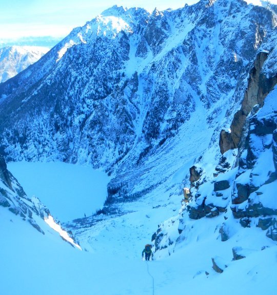 an abyss. We wade carefully higher until we reach a moraine where the snow is firm and the walking easy.
By 8:00 a.m. we are at the base of our couloir where we gear up for the climb. We are equipped with helmets, harnesses, mountaineering boots, crampons, two ice tools for Jordan who will lead, one ice axe for me, ice screws, a snow picket, two cams, slings, a 30-meter rope, plus our personal bags with food, water, and extra layers. We tie into the ends of the rope; then Jordan coils the rope until there is about 20 meters between us, a solid amount for running belays.
The climb starts in a 45-degree couloir. The snow is covered with a firm ice crust. I kick my crampons in to gain purchase, thankful for their presence. About a hundred feet up, we encounter our first obstacle—a steep 30-foot headwall glazed with breakable crust. Jordan tools up cautiously, and attempts to place an ice screw. Initially he finds nothing solid but climbs a little higher and is able to set a solid screw. He moves smoothly upward, sets a second screw, and, higher still, sinks the picket for a belay anchor.
The rope tugs tight: It’s my turn. The ice suddenly looks much steeper. I hack my way up to the first screw. With only a single axe, I find myself kicking and stemming my feet creatively to gain purchase. I also jam my free hand into the ice for purchase and balance. Typically I would be unnerved by this pitch; today I am invigorated.

I feel alive as I kick, step, and climb higher. We belay once more through a second steep pitch, protecting it with an ice screw and a Camelot before sinking the picket for an anchor. After this we find perfect snow on a 45-degree sustained slope leading to the notch marking the exit from the couloir. At the notch we emerge from the culvert of the couloir and our world instantly expands. The grandeur of surrounding peaks exhilarates us and propels us higher.
From the route description, I had envisioned the remainder of the climb up the west face to be an easy walk. Not true. The heightened exposure, soft snow, and lack of protection makes the climb seem more challenging. Time evaporates as Jordan swims upward through snow. My confidence begins to unravel with the increased exertion. I stuff down some leftover holiday fruitcake and my body welcomes the calories – apparently there is a time and place for everything, even fruitcake.
Onward and upward we go until we finally reach low fifth class rock. We scramble out of the shadows and emerge onto the sun-soaked peak of Colchuck Mountain shortly after noon. The climb has given us a good amount of push — while within our ability level, it was a little outside of our comfort zone.

We sit on the top and, for a time, everything else about our lives fades. There is only this moment, this mountain, and this mountain-sized sense of accomplishment. Of course the need to get down eventually intervenes and, around 1:00 p.m., we start the descent via the Colchuck Glacier route.
This route is a comfortable 30-degree slope, passing below the face of Dragontail Peak. We keep our distance from the face — rockfall can be prevalent, although everything is frozen in place today. The glacier and the gullies below the glacier lead us down to the lake where we listen to all the disconcerting groaning of ice while retracing our route back to camp.
The climb — covering seven miles and 3,300 feet of elevation gain — has taken eight hours tent to tent. We take an hour to pack up, boil water, change, and eat before we begin the trudge down. We leave camp with only 90 minutes of daylight before dark. Crampons are essential as we descend the icy switchbacks from the lake to Mountaineer Creek. The final miles of trail leading to the trailhead pass in a trance as our eyes adjust to the darkness and our feet, with minds of their own, follow the trough in the trail before them.
We reach the snowed-over Eightmile Road with a severe case of the “If Onlys.” “If Only” we had skis to effortlessly glide the final four miles of road leading down to the car. Instead we plod and we suffer. Around 7 p.m., a good thirteen hours after we started our climb, we are finally down and done.

Time clocks differently on long days like this one in the mountains. Thirteen hours of working and worrying, shivering and sweating, suffering and succeeding, ascending and descending, is a much longer and more vivid experience than thirteen hours at home. It wears you out, yet fills you with strength and beauty. Which is why I tell those who will listen: “Get out, and be filled.”
Details Details: North Buttress Couloir
Skill: 2+ (advanced intermediate). Fitness: 2+ (advanced intermediate).
Access. Roadside parking is available near Bridge Creek Campground about eight miles up the Icicle River Road, west of Leavenworth. No permit is needed in winter or spring. In other seasons, there is vehicle access up Eight Mile Road to the Mountaineer Creek Trailhead where a Northwest Forest Pass is needed.
Approach. Walk and/or ski 4 miles up Eightmile Road to the Mountaineer Creek Trailhead. Follow the trail up Mountaineer Creek for about 2.5 miles to a fork. Go left here, following the trail leading to Colchuck Lake. Overnighters usually prefer to camp at the south end of the lake. You’ll save time if you visit early enough in the season to travel across Colchuck Lake (on an average year, the ice on the lake starts breaking up around mid-May). More details about the trail to Colchuck Lake can be found in the Hiking guidebook.
Descent. Once you reach the summit, the descent to the notch above the Colchuck Glacier is quite easy. Continue descending the glacier on slopes of moderate angle.
Mileage. 25 total miles in winter conditions: 9 miles from parking at Bridge Creek Campground to Colchuck Lake, 7 miles to complete the ascent and descent of NBC, 9 miles from Colchuck Lake to car. Total mileage is about 17 miles once you can drive the Eightmile Road to the Mountaineers Creek Trailhead.
Equipment. Crampons, harnesses, helmets, 30-meter rope, ice tools and/or ice axe (depending on condition), ice screws, a snow picket, a couple cams (optional), and slings.
Note. Always check the NWAC forecast before heading into the mountains. Accidents still happen when the hazard is listed as ‘Moderate.’
Map. See our topo map of the area. Or visit the Forest Service office in Leavenworth for maps of the area.
Permits. A Northwest Forest Pass is needed to park at the Mountaineer Creek Trailhead once the Eightmile Road opens in late spring. Permits are needed for overnight camping in the Enchantment Zone from June 15 to October 15. The lottery application process for the 2015 season begins Feb 15.
Leave It Better Than You Found It: This should be every outdoor user’s goal. Pick up trash left by others, pull some noxious weeds along your route, throw branches over unwanted spur trails, don’t cut switchbacks in the trail…
Disclaimer. Treat this information as recommendations, not gospel. Conditions change and those contributing these reports are volunteers–they may make mistakes or not know all the issues affecting a route. You are responsible for yourself, your actions, and your safety. If you won’t accept that responsibility, you are prohibited from using our information.
This post was originally published on 1/27/15.