Winter in the Enchantments
Chester Marler’s book, East of the Divide, is enjoyable and informative blending of history, natural history, and adventuring all focused on the east side of the Cascades. The following excerpt, describes a winter trip into the Enchantments and is taken from Chapter 12: On Skis and Snowshoes.
In the Lee of Winter Storms: The Enchantment Basin
By mid-morning in late February 1964, four snowshoers began traveling up the Ingalls Creek trail, heading for a campsite where Crystal Creek meets the main drainage of Ingalls Creek, seven miles up valley. This was our base camp from where we would climb the steep Crystal Creek valley and enter the Enchantment Lakes Basin. Lower Ingalls Creek lies in a deep, narrow canyon, which tends to trap cold air during the winter months. Where the trail passed close to the creek we could see how cold weather affects a running stream. Patterns of ice had formed between the stream and the snow cover along the banks, and also atop mid-stream boulders. Some were like stalactites, growing downward from the snow edge toward the water. It was an intricate display of snow and ice, with the white snow turning to deeper shades of blue ice as it neared the water’s edge.
Three miles up valley we noticed where elk had wallowed through the deep snow. Whenever possible, they had taken advantage of easier traveling under the shelter of larger trees, where the snowpack was more shallow. Conserving even the smallest amount of energy was critical to their survival. My friend Don, who was in front breaking trail, spotted a large bull elk a short distance upstream, just across Ingalls Creek in a small opening. He seemed to move with ease, his legs long enough to carry his belly above the snow surface. The snow was sufficiently consolidated a few feet below the surface to support his weight. The big bull seemed unconcerned about our presence, and did not waste energy trying to flee. We did our best to avoid disturbing him by slowly resuming our pace.
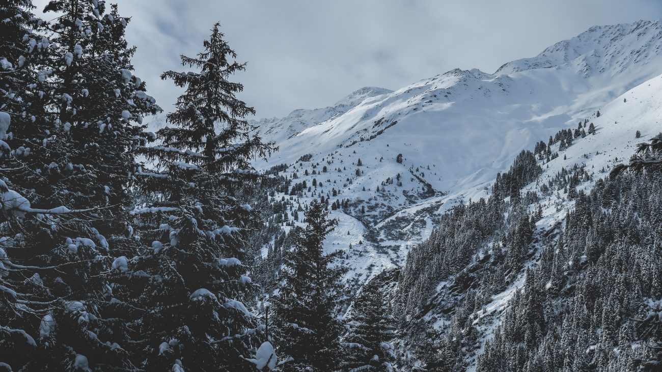
The forest opened after snowshoeing another hour, and in front of us was a 50-yard-wide accumulation of avalanche debris, a jumbled mass of frozen snow and conifer limbs. Little imagination was needed to understand what it must have been like as the torrent of snow and debris crashed down the avalanche path, coming to rest at the bottom of Ingalls Creek Valley. The mass of snow had covered part of the creek earlier in the winter, still largely in place after several weeks, except for a tunnel melted by the moving water of the creek.

In the Cascade Range, avalanches of this scale, running the full length of an avalanche path, are often the result of heavy rains on top of a fresh, unconsolidated snowfall. Rain will penetrate to a weak layer some distance below the surface, weakening the snow bonds and adding weight. Eventually a critical point is reached; a massive slab of wet snow is released, dissipating its energy and debris along the way until it comes to rest in the valley bottom. Such large-scale avalanche cycles occur sporadically. Some winters it may happen several times, other years not at all. Their frequency is sufficient to have created, and maintained, the alternating pattern of openings and forest cover, so characteristic of Cascade valleys. In the autumn, avalanche chutes are filled with reds, yellows and oranges, as vine maple, mountain ash and other shrubs are transformed from their summertime green. In most Cascade valleys the bottom portion of avalanche chutes, the run out zones, give unobstructed views of the surrounding peaks. In this case we enjoyed the granite spires of the eastern part of the Stuart Range, rising as much as 5,000 feet above us.
We reached camp just before dark, with barely enough time to set up our tents. Our party immediately grew from four to six. Two of the group had snowshoed up valley the previous day, and had established a comfortable camp. While we were traveling toward camp they had snowshoed most of the way to the top of Crystal Creek, just short of the Enchantment Basin. Their reconnaissance had been fruitful, and reported good news for the rest of us, finding the route to be mostly well consolidated snow, firm enough to climb much of the way without snowshoes. They had carried their snowshoes through most of the steepest terrain until nearly halfway to the basin. A thaw, followed by a period of cold weather, had created a firm crust. Clear nights had compounded the cooling process.The following morning we likewise made rapid progress, using the steps kicked in the snow the previous day.

By late morning a storm front began to cover the Stuart Range, dusting us with snow showers as we climbed higher toward the Enchantments. Just before noon we entered the cirque-like basin below Crystal Lake, although by now the crust had all but disappeared. Shortly before we had strapped on our snowshoes, after we began breaking through the crust into softer snow. At this point we were above the elevation where the previous week’s alternating warm and cold cycle had created the strong crust. It had remained cool enough at the highest elevations for the snow to stay relatively dry, with little melting, even though the overall snowpack was well enough consolidated for enjoyable snowshoeing.

The snow fell harder as we crossed the frozen surface of one of the middle Enchantment Lakes, and became so intense I stopped to pull on my shell anorak. Just before climbing the last few hundred vertical feet to Prusik Pass, I glanced to the west and could see the summit of Little Annapurna, with blue sky surrounding it. The storm front had weakened for a short time, with its edge retreating to the west barely enough to give us 45 minutes of broken clouds. We were far enough east of the Cascade Crest so that small changes in the intensity of the storm could give us periodic clearing, followed by short duration snow showers. The Enchantment Basin, lying at the eastern extremity of the Stuart Range, is often in the lee of southwesterly storms. High summits to the west absorb the majority of a storm’s intensity, leaving the Enchantments with less snowfall, and consequently more sunshine.
It became bright enough that I stopped and reached into my pack for my sunglasses and camera. The basin was blanketed with several inches of fresh snow, and the sunlight was intense against the snow and blue sky. In less than an hour, and just as we reached Prusik Pass, the snow showers returned. Even so, we could clearly see the Rat Lakes basin and Cannon Mountain. The vertical granite of Prusik Peak seemed much colder with the darkening sky.

The descent to camp was relaxing, snowshoeing easily across the upper slopes, and finally plunge stepping with climbing boots the last few thousand feet. The next day remained overcast as we departed camp and snowshoed the seven and one-half miles to the trailhead. The weather had been less than ideal, but we had been fortunate. The general overcast had been broken by a short period of brilliant sunlight and blue sky. It had happened at the right time, when we could stare at the summits above frozen, snow-covered lakes.
This post was originally published on 1/27/12.
