
Enchanting Substitutes
by Andy Dappen
The Enchantment Traverse is one of Washington’s premier hikes. Because it’s hard to get an overnight permit for the 19-mile trek, many people have given up on backpacking the route. 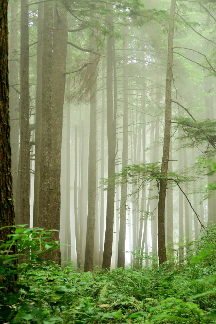 Instead, day hiking and trail running the traverse has become all the rage. So much so that the area is almost crowded and its fragile vegetation is becoming threadbare. Now visitors will find anything but a wilderness experience in this neck of the Alpine Lakes Wilderness.
The solution? Give the Enchantments a break and find other enchanting alternatives. The South Olympic Coast traverse between the mouth of the Hoh River and Third Beach on the Olympic Peninsula is such an alternative. This route is typically spanned as a two- or three-day backpacking trip but, given that permits are needed, permits come with a cost, and food barrels must be carried to deter bear and raccoon encounters, it’s become easier to day hike this 17-mile route along the Pacific Coast. I did this recently and can report the journey equals the Enchantments in beauty and wonder.
 The trick of this and other coastal traverses is contending with the vagaries of the tides. Lower tides are sometimes necessary to round precipitous headlands situated at ocean’s edge. Between the various headlands, beaches are strung along the coastline like the pearls of a necklace – however they, too, are most easily traveled when the tide is out. Successfully navigating all this without getting stranded by high tide means paying attention to the ocean’s cycles and scooting along efficiently when low water allows. Here’s how the adventure played out for me recently:
11:30 am – 1:25 pm
With the tide just having peaked and beginning to recede, I leave the end of the Oil City Road and quickly reach the mouth of the Hoh River. Here a junkyard of driftwood logs must be hopped to reach a tangle of fallen trees bordering the ocean’s high-tide mark. Tediously, I climb over or crawl under many a tree trunk. At the first headland, I time the outgoing waves and sprint around problematic boulders when a few feet of exposed beach materializes between wave sets.
Soon a second headland is reached. It will require a half hour’s wait before the falling tide provides beach-front property around it. A notch in this impasse may allow overland passage so I scramble up to the 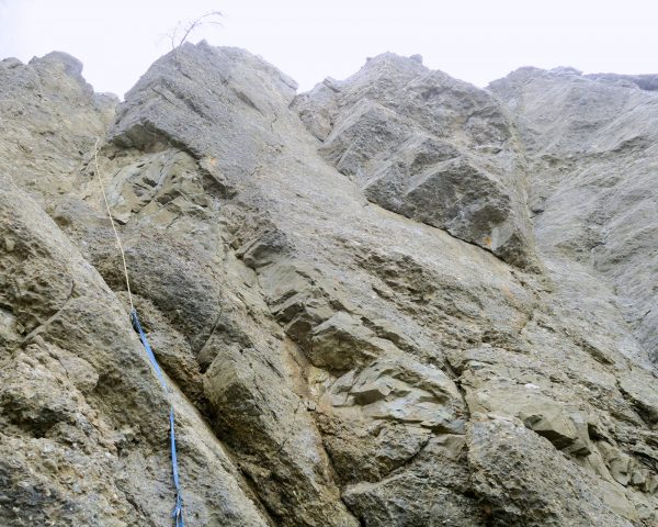 notch. The opposite side proves to be an exposed climb down rubble that is as much gravel as rock. A weathered, rodent-gnawed rope hangs over the worrisome descent. What a choice: wait and risk wasting low water farther along the route, or risk one’s neck to loose rock and a rope that may snap if fully weighted. Mountaineers hate such false protection but I grab the rope, test the anchor, and carefully make the exposed climb downward, making light use of the rope. Good fortune gets me back to beach level without needing to hang on that shabby line. I break for a 20-minute lunch; then follow boulder, cobble, and sand beaches to Hoh’s Head.
1:30 pm – 3:30 pm
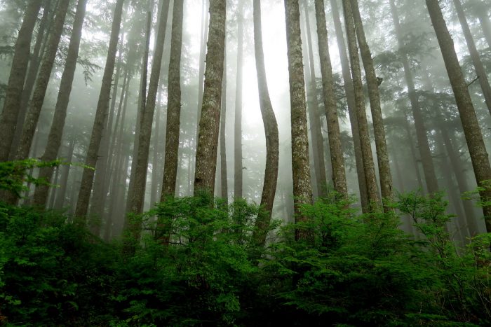
Three-and-a-half miles of utterly slow trail leads over Hoh’s Head, a massive buttress jutting into the ocean. The trail is rocky, rooty, muddy, and boggy. It has ropes, ladders, board walks, and balance beams. A dozen times it climbs up 100 feet and then dips down nearly the same distance. I want to rush, but to hurry is surely the formula for going slow. You can slip, tweak, twist, slam, dislocate, or break yourself on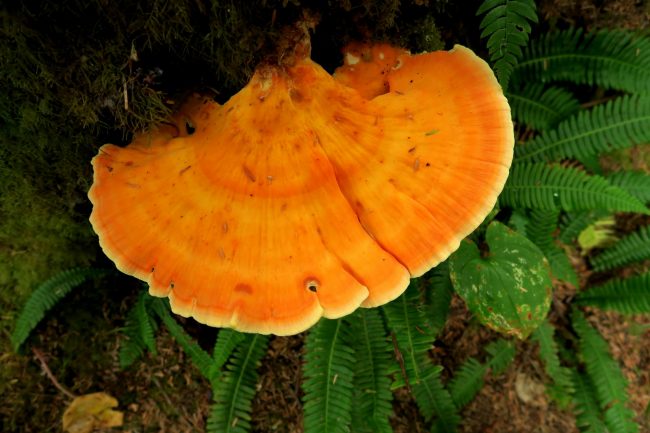 anything slippery. And everything is slippery. Despite all this, the trail is wondrous with its humongous hemlocks, colossal spruces, and redwood-sized cedars. Chartreuse moss, orange fungi, purple mushrooms are like neon lights glowing through the green screen of salal, sword ferns, deer’s heart, wood sorrel, and salmon berries. Every time I try to hurry, I must stop to pull out the camera.
“Make time, rush, the tide is going out,” these voices pull. “Step carefully, don’t slip, take that picture,” these warnings push. At the end of this trail I take stock: I’ve been traveling four hours and have barely started.
3:30pm – 4:30pm
Finally there’s good beach. Gotta move: jog, walk fast, eat on the go. Keep the legs moving and let the eyes absorb the setting: sand, pebbles, and cobbles; pearly everlasting, fireweed, and goldenrod; sand pipers, Western gulls, and Heermann’s gulls. Three sets of footprints flow against me – yes, I saw a group camped a mile back at Mosquito Creek. New tracks: one doe with a fawn, several raccoon, ravens, scores of shore birds. Flotsam: orange buoys, blue bottles, green nets, and yellow polypropylene rope. Distance flies.
 What? I’m dead ended. No beach around these cliffs. Did I miss the overland trail? Must have. Retrace. Run. Ha — there’s a rope headed up that steep slope I didn’t see! Darn: 20 minutes lost.
4:30pm – 5:00pm
Without trails around several headlands that are too sheer to walk around at all water levels, this traverse would not be possible. I start the 1.75-mile trail around the Goodman Creek headland. Spanning this ground would be utterly impossible had not machetes and chain saws cleared the way. The salal fields and brambles bordering the paths are beyond heinous — they would slow travel down to about two miles per day. The tide is all the way out. What a waste to be traveling overland. I hoped to be farther along using the low tide for beach travel.
5:05pm – 6:00pm
Making good time north of Toleak Point. Sand beaches lead past Strawberry Point and the Giant’s Graveyard. Sea stacks and waves. Kelp and eel grass. Butter clam and cockle shells. Legs and claws of dead crabs. The breeze is fresh on skin and lungs. Time and distance scroll under running shoes.
An orange sign tacked to a tree marks another overland trail. I won’t waste time running past this one. I approach a man camped near the sign, “Is this the trail around Taylor Point?”
He’s confused. He points to the cape northwest of us. “That’s Taylor Point there, so I guess so.”
I don’t know it yet, but this is actually the trail rounding Scott’s Bluff.
6:00 pm – 7:40 pm
After 7 or 8 minutes the trail splits. The less traveled left fork surely goes to a campsite. I fade right and am soon climbing steeply. This seems as it should. Thirty minutes later nothing seems as it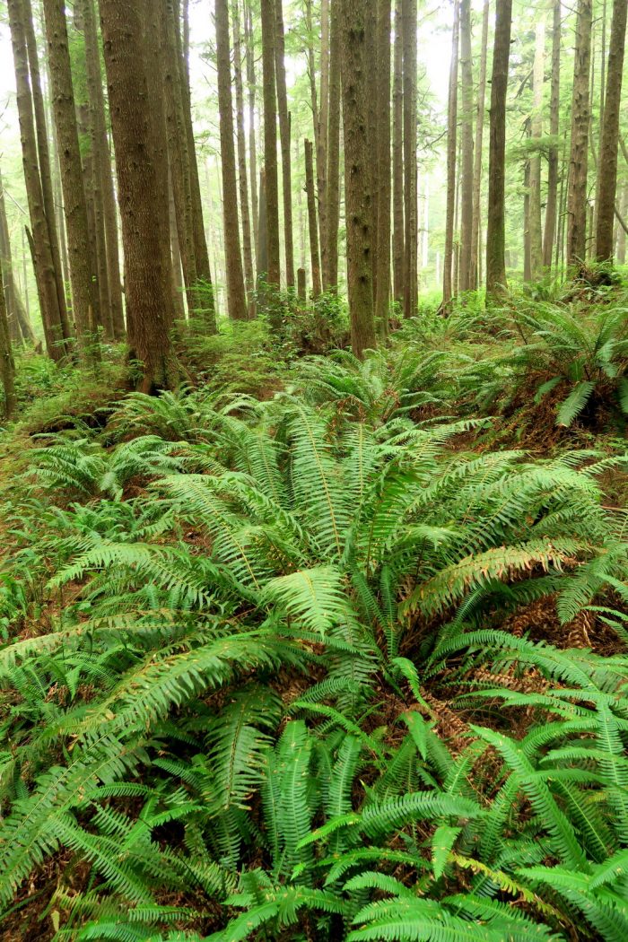 should. I should be coming down onto Third Beach, but I’ve walked farther and farther inland. My trail merges with an old logging road. I jog the road and the scars of logging get newer. Eventually signs indicate this is state land. I pull out my park schematic – it’s a pathetic map for real navigation but it indicates none of the overland trails come close to state land. I retrace on the run. Back at the trail split passed an hour ago, I turn left and quickly find a rope allowing me to batman down slippery, sandy slopes leading back to the beach. Another short beach walk leads to the Taylor Point Trail I thought I had reached 90 minutes earlier. Relief flows – I was lost, but now I’m found. Worry also erupts – it will be a race to finish the route before dark. At darkness the shuttle driver waiting for me at trail’s end will leave.
7:40 pm – 8:35 pm
The 1.25-mile trail over Taylor Point is well traveled and in better shape than the trails farther south. Am I in great shape or is adrenaline giving  me a third wind? The trail gives way quickly to determination; so do the sands of Third Beach. At 8:10 pm, I start up the final 1.5-mile trail connecting Third Beach to the road leading to the hamlet of La Push. What is my shuttle driver’s exact definition of “darkness?” Will that be true blackness, or will it be some gradation of gray? In some incarnation of an Oscar Wilde story I see myself reaching the road just as the taillights of my ride disappear in the distance.
The legs go into overdrive. Everything feels heavy — I haven’t stopped for food or drink in over three hours and the engine powered by adrenaline alone eventually stalls. I don’t dwell on this but on the disappointment to be experienced if I’m a few minutes late. The atmosphere below the canopy of the surrounding 250-foot hemlock trees is charcoal — I should don a headlamp to prevent stumbling on a shadowed cobble, but the minutes lost will not be regained over the short distance remaining.
Twenty minutes before true darkness I reach the road. I see my ride and my worries vanish. I jog toward the car letting my mind flash over the beauties and the enchantments of the past nine hours – what a rush! My driver watches my double-time approach. He cocks his head and curiously studies the sweat streaming down my face. “Hey man,” he says nonchalantly, “what’s your hurry?”
–The End—
The South Olympic Coast Traverse leads from the end of the Oil City Road near the mouth of the Hoh River to Highway 110 about 2 miles southeast of La Push. Tide tables and a good topographic map (neither of which our foolish author carried) are highly recommended. Day trippers should carry emergency overnight items (extra food, water purifier, tarp, fire starter) in case the rising tide strands them along the way.
