Ancient Lakes-Loop to Loop
by Andy Dappen
The November shoulder season has descended like rain from heaven. Actually, it has descended because of the rain from heaven. A frigid and unpleasant mixture of rain-snow is forecasted for the mountains. The foothill trails around Wenatchee are swampy and riding them will cause ruts that will have other trail users wanting to cut the culprits into cat food.
It could be a good day for college football – except Washington’s teams are so wretched this year that cold, miserable riding in the rain beats watching the UW Chiwawas or the Washington State Kitties. Then the solution dawns: It’s a day to ride the Ancient Lakes near Quincy. I call Martin Straub and in my recruitment efforts for Team Stupidity I’m not above a white lie, “The odds of getting rain out there are smaller than the odds of getting hit by a meteor,” I tell him.
The NOAA weather forecast begs to differ. Accompanying the forecast for Quincy are illustrations of black clouds and sheets of gray rain. Sure, the meteorologists have computer models to help them, but these tools pale next to local knowledge. I tell Martin a 60-percent change of rain in Quincy is equivalent to a 0 percent chance in Seattle.

Martin and I meet in Wenatchee where puddles adorn the streets but, by the time we’re on the outskirts of Quincy, the roads are dry. We strut as we saddle-up, “Did we nail it today, or what?”
We did nail the weather but because we’ve decided to explore new rides around the area, the rest of the day remains a mystery. Our first foray, a promising route on the map, proves dismal. We end up pushing our mountain bikes through fields of chest-high noxious weeds. Strike one.
We abandon that route and follow roads to the NE corner of the lake basin. From here, we try approaching the coulee with four ponds, collectively known as Ancient Lake, by mountain biking near H Lake and above Judith Pond. The first mile of the route is beautiful and provides excellent riding. We’ve just congratulated each other for our ‘find’ when we find ourselves looking down steep scree. It borders on sin to carry bikes downhill but, even for gnarly-bros on downhill bikes, a wheeled descent of these slopes would be a bone breaker. Non-gnarly guys like us don’t stand a chance–we shoulder the bikes and pick our way down. Strike two.
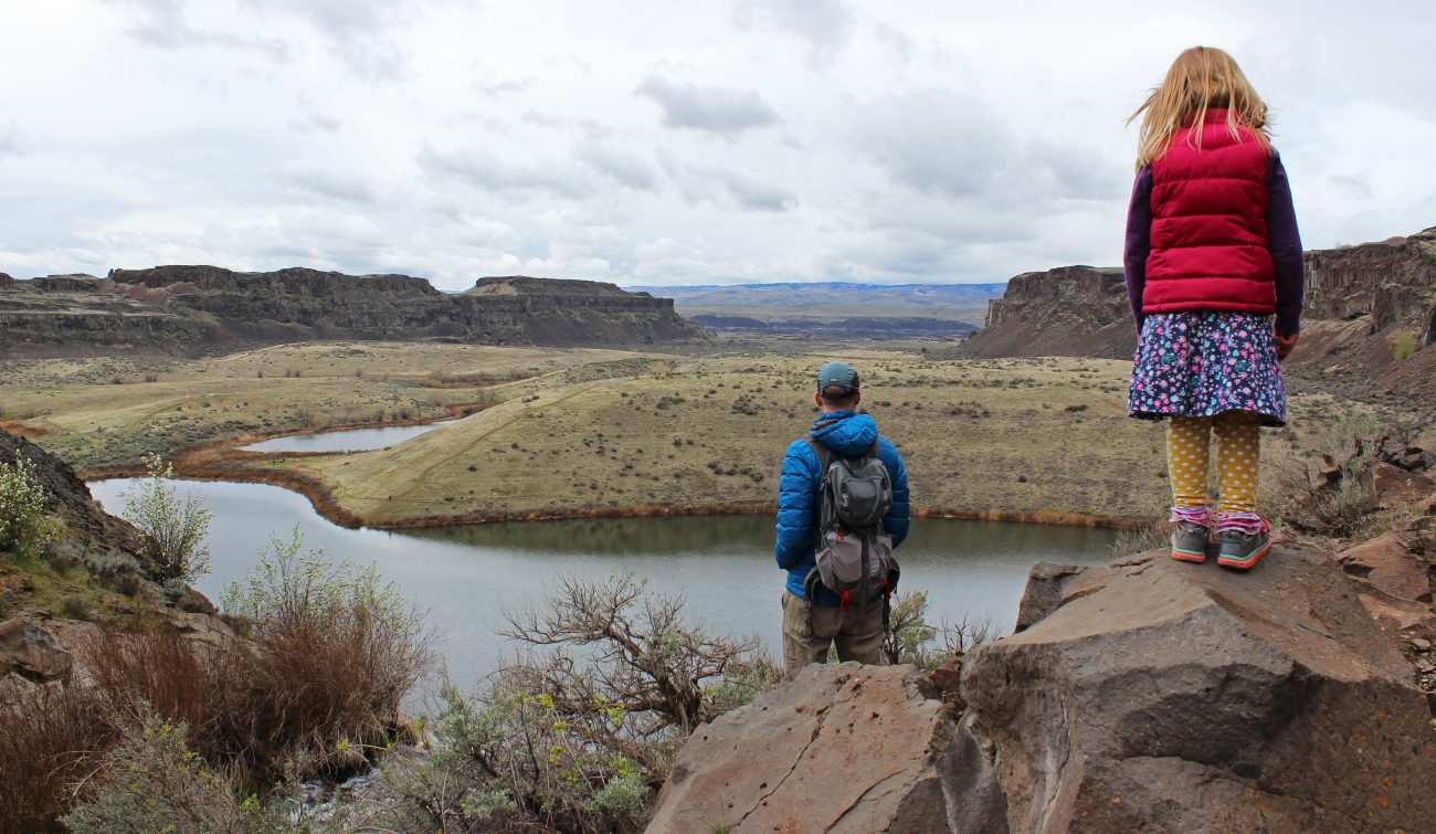
Descending into the lake basin and circling its easternmost lake with a bike biting the shoulders and stiff cycling shoes slipping on boulders is unpleasant. But there’s a silver lining: This descent connects to other trails I’ve walked to form a 4.5- to 5-mile loop walk I hadn’t known about. The details of that hike are described below.
There’s another silver lining: Once we get around the talus lining the easternmost lake, the mountain biking becomes most excellent. We ride out the cliff-lined coulee containing the Ancient Lakes, and then hang a left where we ride several miles of double-track road along the Babcock Bench. Near the Gorge Amphitheatre, we ascend a steep jeep road and access a higher mesa pitted with sinks and mounds. We follow a wandering series of trails and roads leading to the SE corner of the public lands containing these lakes.
Most of this riding has been following the friendlier parts of Fred and Frank’s Loop. Where Fred and Frank’s Loop starts to bare its fangs, however, we look for easier passage through these public lands with their hidden lakes and cliff-lined coulees. Is there a circuit better suited to intermediate riding skills? It requires a few false turns, but we uncover a reasonable series of connections that deliver us to the Evergreen Reservoir. Here the remainder of the route back is an easy pedal along a well-maintained gravel road–we congratulate ourselves for our awesome route-finding.
Mission accomplished…but not complete. The silver lining in the clouds splits and rain spills out. Not in a delicate drizzle but in an enduring downpour. We ride like stiff, shivering scarecrows, and it doesn’t take long for Martin to question the dog that delivered him here. “What was it you said about the likelihood of rain around Quincy?”
We round a bend in the road and roll into the lot where we parked. We’re shocked to discover that we’ve entered a microcosm of destruction. The ground is buckled, the surrounding vegetation is vaporized, and a there’s a house-sized crater in the middle of it all. We roll to the brink of the crater and peer in. At the bottom, the mangled wreckage of my car sits beneath the glowing metallic boulder of a meteor. Strike three.
Attractions: On the fringes of the flat agricultural fields of Quincy is this surprising maze of sunken lakes, basalt cliffs, coulees, brown boulders, odd hummocks, reservoirs and waterfalls. It’s an area rich with birdlife, deer, and an area where lush riparian vegetation juxtaposes sharply with stark desert flora. Dude-talk for all this? “Super cool!”
Access: These loops can be accessed from the Babcock Bench as described in the mountain biking entry ‘Ancient Lakes-Fred and Franks Loop’ or the hiking entry ‘Ancient Lake-Dusty Lake.’ The hiking loop below is 4 miles longer if accessed this way, the biking loop 1.2 miles longer. The access described below gives the shortest hike and ride.
- From Wenatchee, go east on Highway 28. About 4 miles before downtown Quincy, turn south (right) on U – NW Rd. Drive 4.7 miles on U and, about 1.1 after the road hooks left and heads east, turn right onto a good gravel road. Follow the gravel road 0.8 miles to a parking lot on the right. Park (elevation: 1,200’)
Ownership: These public lands are part of the North Columbia Basin Wildife Area (Quincy Unit) and are managed by the Washington Department of Fish and Wildlife.
Permits: A Discover Pass is needed to park. This can be purchased online or wherever state fishing and hunting licenses are sold. A number of areas in the WenatcheeOutdoors guidebooks (e.g., Ancient Lakes, Swakane Canyon, Colockum and Chelan Butte) are on Washington Department of Fish and Wildlife lands. Hunting and fishing licenses help support these properties, and other recreationalists are likely to find these lands being hunted throughout the fall and winter.
Map: See our topo map. Print this map in portrait mode on 8.5” x 11” paper.
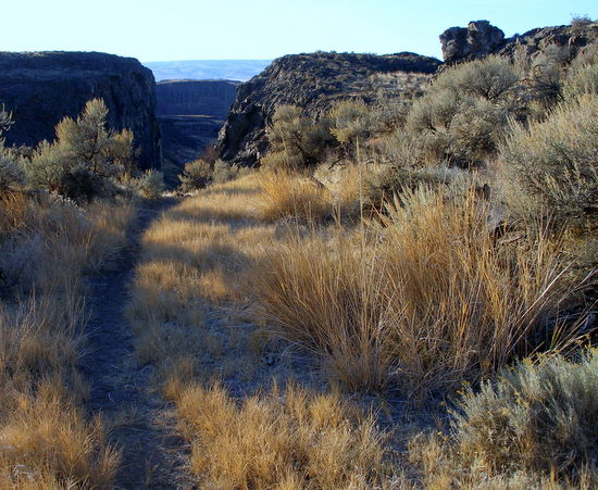
Hiking Loop. Other than a plaque at the parking lot stating “Ancient Lake Trail”, you’re out of luck when it comes to signage around these parts. Print our map and pay attention to the twist and turns of the route. Length: 4.5 miles. Elevation gain/loss 400 feet. Difficulty: the route is not difficult strenuous, but the loose tricky walking getting down into the Ancient Lake coulee makes this, technically, a hike for advanced intermediates (2+) and up.
- The first mile of this trail has various spurs that come and go – just follow a spur going west for 0.3 miles, then head north a few hundred yards before heading west again as you contour above Judith Pool. Beyond Judith Pool, keep going west as you drop down to the easternmost Ancient Lake. During this descent, which is loose and a bit tricky, stay on the north side of the stream cascading down into the lake.
- Descend to the lake and then, staying roughly 5 to 15 vertical feet above lake level, contour and boulder-hop around the lake in a counter-clockwise direction. This portion of the route is not particularly distinct–threads of trail stomped into the talus come and go.
- Once around the first lake, contour around the western side of the southernmost lake. Find the trail on the south end of this second lake that heads up the slopes confining the lake. (Thissounds like jibberish unless you use our map). Follow this trail about 1.6 miles uphill through interesting but convoluted terrain.
- At a major gravel road, turn left and follow the gravel road 1.25 miles back to the start.

Mountain-Biking or Trail-Running Loop. Like the hike, there is almost no signage along this route, so pay close attention to the map and instructions. Length: 15.5 miles. Elevation gain/loss 650 feet. Fitness: 2 or intermediate. Technical difficulty: 2+ or advanced intermediate–the loose, tricky walking getting down into the Ancient Lake coulee is harder than the biking.
- Work down and around the easternmost Ancient Lake as described in the hike above. At the divide between the lakes in the Ancient Lake coulee, head west for 1.5 miles to reach Babcock Bench.
- Upon reaching a dirt road that runs north-south along the Babcock Bench, turn left. Head south on this dirt road for 3.9 miles. Reach an intersection below the Gorge Theater where the main road seems to hook left. Go straight here on a lesser road and, in 100-plus yards, reach a jeep road that climbs up the little canyon below the Gorge Theater.
- After climbing the jeep road for 0.4 miles, the Gorge Theater is across a little drainage from you. Look for a smaller trail on the left that splits off and climbs more directly toward a big house/ranch straight above you. Take that trail.
- As the trail climbs, it curves and soon you’re headed north rather than east. For about 1.3 miles, you’ll follow a little cattle trails that come and go. For much of this time, you’ll be close to the barbed wire fences of ranches on your right.
- Intersect a small, double-track road, turn right and head east 0.4 miles. (Note: An altenate, but trickier, route for this step and the next is to turn left on the double track and, when it ends in about 100 yards, follow faint game trails in a NE direction for 0.8 miles. Intersect the powerline road at the very place the singletrack branches off to the NE).
- Reach a larger road running under the power lines, turn left and go north 0.5 miles.
- Look for a single-track trail intersecting the road. Turn right on the trail and follow it 0.6 miles through undulating sagebrush country.
- Merge with a double track road and follow it for about 0.1 mile to a dilapidated wooden shed/barn. Keep the barn on your left as you go by. A few hundred yards past the barn, reach a fork in the road. Take the right branch and head roughly 1.2 miles in a southeasterly direction until the dirt road reaches the outer edge of a vineyard.
- Follow the perimeter of the vineyard east for 0.5 miles to its northeastern corner. Here you can follow the edge of the orchard south for another 0.5 miles, hit a gravel road and turn left and head toward the Evergreen Pumping Plant (distinguished by its big tower). The problem: You’re actually on private property here. We recommend going straight east from the NE corner of the orchard and traveling cross-country over to the main gravel road described below (there will be a few barbed-wire fences to deal with that are easily stepped over and one marsh that you get around on the uphill side (see map)).
- Regardless of the method used above, go north on the main gravel flanking the west side of Evergreen Reservoir. This road leads back to the start in 2.5 to 3 miles.
Leave It Better Than You found It. This should be every outdoor user’s goal. Pick up trash left by others, pull noxious weeds along your route, disperse old fire rings, and throw branches over unwanted spur trails.
Disclaimer. Treat this information as recommendations, not gospel. Conditions change and those contributing these reports are volunteers–they may make mistakes or not know all the issues affecting a route. You are completely responsible for yourself, your actions, and your safety. If you won’t accept that responsibility, you are prohibited from using our information.