Mission Ridge Ski Area Ride – Up the Down Staircase
by Andy Dappen
Sunday obligations had hampered our departure from Wenatchee. By mid-afternoon we were both free, but the  longer ride we had discussed was no longer feasible. “Let’s just ride up the ski area,” my partner suggested, “the fall colors should be great.”
I was less than excited. Rolling up the resort I frequently ski down elicited a yawn. And yet I had never ridden the ski area service roads. “Try it before you knock it,” I told myself.
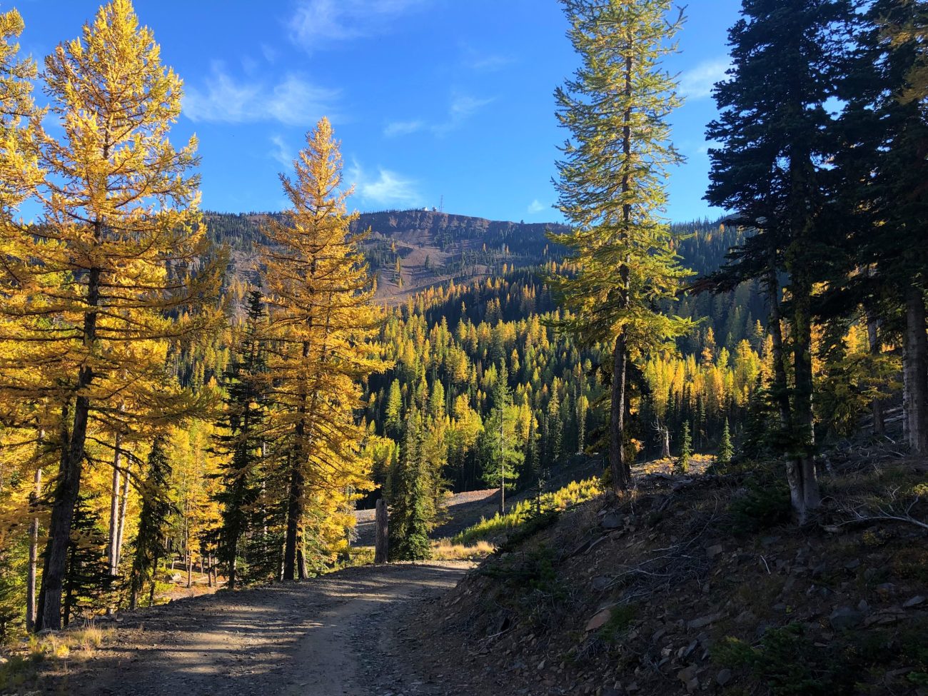
And so we sweated up the 4.5-mile road leading to the top. And, surprisingly, I came away liking the ride. Not only were the larches and broadleaf foliage spectacular shades of gold and red, but the views over the Bomber Cliffs and down the Columbia Valley were spectacular. Plus, there were no hunters to fret about during the somewhat worrisome month of October. In fact, there were no people to worry about period. While 30-some cars were parked where we started, all of those visitors had headed up the Clara Lake Trail or the Pipeline Trail, leaving the entire ski area to us two cyclists.
In the end, the ride up the Mission Ridge Ski Area delivered plenty of kicks and not a single yawn.
Details, Details: Mission Ridge Ski Area Ride
Activities. While the service road within the ski area can be walked, this is a better trip for tires (mountain bikes or gravel bikes) than for legs (hiking or running). The road’s surface is sometimes dirt, sometimes cobbles, and frequently a mixture of both.
Attractions: Views, colors (in autumn and wildflower season), and the absence of traffic (in non-skiing months).
Distance: 9 miles (round trip).
Elevation Gain: 2300 vertical feet.
Skill: 2 (intermediate). Intermediate uphill skills are required to keep the bike from spinning out on the cobbled sections of the ascent. The descent is bumpy but, technically, fairly easy.
Fitness: 2 (intermediate). The entire ascent is ridable for those with good uphill technique and strong legs. Nonetheless the grade is consistent (sometimes steep) and requires reasonable fitness to tackle.
Nearest Town: Wenatchee.
Map. For a geo-referenced map that works on a smart phone, upload our PDF map into an App like Avenza.
Access. From the south end of Wenatchee, drive up Squilchuck Road roughly 11.5 miles to road’s end at the Mission Ridge Ski Area. Park near the entrance to the ski area parking lots close to the Clara-Marion lakes trailhead. Even if the gate to the ski area is open, park outside of the gate so your vehicle does not get locked inside the ski area parking lot during your ride.
Trip Instructions. From your vehicle, ride across the ski area parking lot to the Hampton Lodge (the main day lodge at the base of the ski area). Follow the service road on the uphill side of the lodge that heads behind the lodge to looker’s right. This road is particularly steep for the first few hundred yards and then climbs at more reasonable angles once it starts paralleling Chair 1, the chair leading to the resort’s mid-station. Very near the top of Chair 1, follow the road when it hooks sharply to the left and bends toward the Midway Lodge (note: the lodge is actually only a quarter of the way up the mountain, not midway up the mountain). The road passes by this small lodge on its uphill side, cuts under Chair 2 (the main chairlift headed to the top of the mountain) and starts climbing steeply for several hundred yards on a loose, cobbled surface — this is, arguably, the hardest portion of the ascent. After about a quarter mile of difficult climbing, the road dials back in steepness and the surface firms up in consistency, making the remainder of the ascent easier to ride. The road keeps zig zagging uphill and occasionally spur roads intersect the main service road. In such instances, always stick to the largest, most-travelled road and you’ll eventually find yourself on the top of the ski area where Chair 2 ends and where a myriad of communication antennas rise. For a good view south toward Ellensburg and Mt Rainier, ride the road leading toward all the antennas until it ends, then boulder hop across a jumble of talus to reach the top of the ridgeline.
More Rides: Maps and details of over 100 regional rides in our mountain biking guidebook.
Fees or Permits: none required.
Land Ownership. The bulk of the ski area is made up of state (WDFW) and federal (Forest Service) lands.
Leave It Better Than You found It. This should be every outdoor user’s goal. Pick up trash left by others, pull noxious weeds along your route, scoop your dog’s poop, don’t travel off road or off trail….
Important Disclaimer: Treat this information as recommendations, not gospel. Things change, conditions change, and those contributing these reports are volunteers–they may make mistakes or may fail to give complete information. You are still responsible for yourself and your actions. If you can’t live with that, you are prohibited from using our information.

