Ancient Lake-Fred & Franks Loop
by Andy Dappen
I was introduced to this super-scenic route and the complex terrain around the many lakes and ponds surrounding Ancient Lake area (fed by Columbia Basin irrigation water) by friends Fred Rose and Frank Wycoff. Fred and Frank had spent a lot of time poking around these parts, and had strung together threads of jeep roads and single track into an amazingly interesting and scenic loop. Unfortunately two-thirds of the way through my introduction to this loop, I hopped off a little rock shelf, lodged the front tire, and took a flight over the handlebars. The bike skipped forward with me and I landed on my upward-pointing handlebars. That cracked a few ribs.
I lay there moaning for several minutes and would have stayed there far longer had I had an audience, but Fred and Frank were out ahead enjoying themselves. In fact, they were quite unsympathetic of my plight at the next trail intersection where they had waited for their anchor to catch up. It had been a fabulous ride to that point—I remember thinking how varied the terrain was, how scenic the red rock was against the blue sky and the green cattails of the ponds we passed, and how surprising it was to have these chain lakes here in the desert. All I remember of the end of the ride, however, was holding back screams as we bounced over rocky terrain that rattled ribs. My notes of the route fell apart and it took me many years to get back to this specific loop with healed ribs and a good GPS to properly document what I consider to be one of the most interesting and unusual mountain-bike rides in the region.
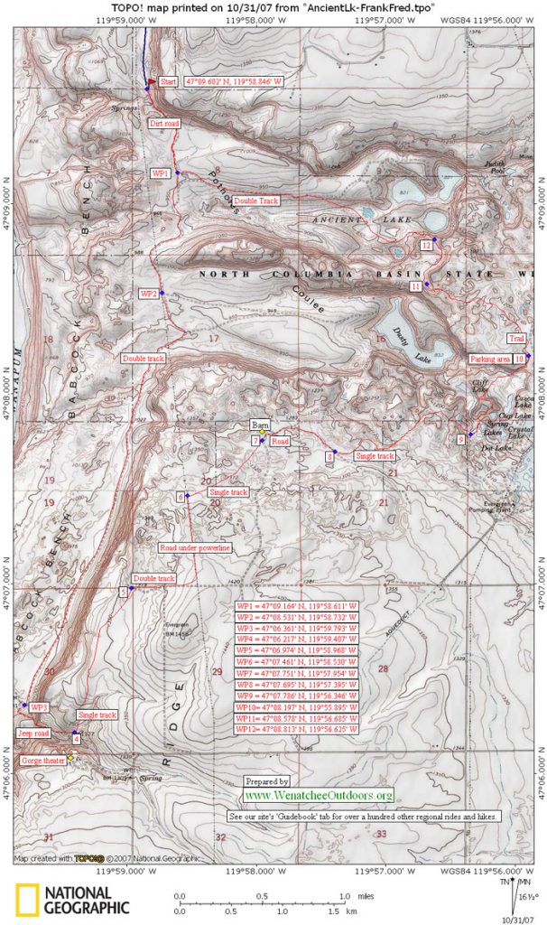
Maps: Ancient Lake and Dusty is on the Babcock Ridge 7.5-minute USGS topographic map and the south portion of the ride is on Evergreen Ridge. 7.5-minute topo. View our topo map (8.5’x11” portrait/landscape or 8.5”x14” portrait/landscape). Note: use ‘Print Preview’ before printing to properly scale this map to a full sheet of paper.
Activity: Mountain Biking, Trail Running
Nearest Town: Quincy
Skill Level: 3 — Strong Intermediates will do fine with the route if then walk some of the downhills.
Fitness Level: 2-plus or 3-minus fitness recommended
Distance: About 14.5 miles.
Elevation: Less than 1000 vertical feet of total climbing.
Recommended Season: Best in spring and late fall after wetting rains. The soil around here gets very loose and sandy in summer…and it gets reeeal hot, too. But the area is one of the region’s fun zones in those shoulder seasons when our mountain zones are still too snowy, too rainy, or too muddy. Some years, this area is even surprisingly hospitable in the dead of winter.
Access: From the west, drive Highway 28 about 2.5 miles past the Crescent Bar turnoff to milepost 25. At a rest area on top of the Trinidad Grade (several miles west of Quincy) turn right on 10 NW, immediately curve right and go around the back of rest area. In 0.4 miles, turn left on V Street (not signed). After 0.9 miles, go right (west) on 9th NW. Now just stay on 9th: after .5 miles it goes down a hill toward the Columbia River, at about 0.75 miles the road hooks left, at 1.1 miles the road turns into a good gravel road, and at 4.6 miles the good gravel road ends at a small parking lot with a sani-can and a gate across the road. Besides the sani-can, there are no facilities. Hikes/rides/runs start just past the gate.
Difficutly: While this ride is well suited to cross-country mountain bikes, the route has several loose, steep, rocky plunges requiring advanced/expert technique to navigate with such bikes. The majority of cross-country riders will find themselves walking short sections of this route. The majority of the ride is within the ability level of strong intermediate riders if they simply exercise the good sense of dismounting when things get dicey. The rocky landings will punish those exercising poor judgment.
Trip Instructions:
–Ride/run south along a dirt jeep road. This road can be very sandy and loose in summer. In 0.6 miles a spur trail branches off to the left and goes up the coulee leading to Ancient Lake—keep going straight on the main road.
–Mile 1.5. Another spur trail branches to the left and goes up to coulee to Dusty Lake. Keep going straight, heading south on the Babcock Bench. Some spur trails branch off in the next few miles but ignore them.
–Mile 4.4. You’ll reach an intersection below the Gorge Theater where the main road seems to hook left. Go straight here on a lesser road and in about 100-plus yards reach a jeep road that starts climbing up the little canyon below the Gorge Theater.
–Mile 4.8. A smaller trail on the left branches away from the jeep road and climbs more directly toward a big house/ranch straight above you and on the opposite side of the canyon. The Gorge Theater is now across the little canyon from you. This trail climbs and the gradually curves from traveling in an easterly direction to traveling north. For about 1.3 miles you’ll ride north picking up little cattle trails that come and go. For much of this, you’ll be riding close to the barbed wire fences of ranches on your right.
–Mile 5.9. Intersect a small, double-track road, turn right and ride east about 0.4 miles.
–Mile 6.3. Reach the larger road running under the power lines, turn left and ride north 0.5 miles on this road..
–Mile 6.8. Look for a single-track trail intersecting the road, turn right on the trail and follow it 0.6 miles through undulating sagebrush country.
–Mile 7.4. Merge with a double track road and follow it for about .1 mile to where you’ll see a dilapidated wooden shed/barn on your left. Keep the barn on your left as you ride by.
–Mile 7.65. A few hundred yards pat the barn, reach this fork in the road. Take the right branch and ride in a southeasterly direction for 0.35 mile.
–Mile 8. Look for a single track trail intersecting this road. The trail is substantial so don’t get lured by a faint spur. Turn left on the trail and follow this distinct trail through more sagebrush country and rolling potholed terrain. If there are any spurs branching off the trail, stay on the best traveled trail.
From this point on, mileage figures are less exact because I took a number of false turns that mucked up the totals. Consequently, the remainder or the trip is broken down into segments with reasonably accurate estimated mileages.
–About 0.4 miles from the road above, you’ll make a short, steep descent and then traverse high above a lake to a little gap.
–For the next 0.5 miles, head in a northeasterly direction before the trail gradually arcs and heads in a southeasterly direction.
–In about 0.25 miles, the trail makes a short, steep descent (intermediate riders might consider walking) to a lake and then head along the shore with the lake on your left.
— Head up the valley. A few hundred yards beyond the lake you will reach a faint 3-way intersection. Keep going straight. The trail will split into two very distinct trails about the time you see the next lake straight ahead. Take the trail to the left. It will drop down into a marshy area, go up a small hill and eventually turn into a very well-travelled trail that winds up and down between many small lakes. You will pass a sign for “Cup Lake”. There is some riding and some walking on this short section. Eventually you will end up on a little perch that looks down on Dusty Lake to the northwest and a coulee with some water cascading down its basalt walls to the northeast. This perch is roughly 1.5 miles from the road you left behind at Mile 8.
–Follow the trail downhill from this perch as is zigzags towards the coulee (intermediate riders should walk parts of this descent). Near the bottom of the descent, there are forks in the trail but take the paths aiming at the waterfalls cascading off the end of the coulee. Cross the stream at the base of these waterfalls (there’s a foot log) and carry the bikes up a steep trail on the left side of the cascading creek (there are handrails along this trail).
–About 0.15 mile above the aforementioned foot log, branch left (north) at a split in the trail. Go north for about 0.2 miles, paralleling power lines that are a few hundred yards to the east. The trail enters a large turnaround and parking area for recreationalists using Burke Lake (across the road). This parking area is about 0.75 miles from the aforementioned perch looking down on Dusty Lake.
–Continue through the parking area, past the cement outhouse, and head north on the main road. Almost immediately (within 50 yards) take a prominent (but unsigned) trail on your left leading off in a northwesterly direction.
–This trail bounces over rocky terrain and has one or two places where you may want to dismount as it heads northwest for about a mile. Then, the trail heads north for about .4 mile before it reaches the edge of the coulee confining Ancient Lake.
–A steep descent (more walking for intermediate riders) leads into the coulee. At the bottom of the steep descent, a trail branches left and heads down the coulee close to the cliffs. This trail provides nice single-track riding for about a mile but gets quite rocky and tricky later. The easier biking option is to descend to the middle of coulee and catch the main double-track road out.
–Continue down the coulee about a mile and intersect the larger north-south road along the Babcock Bench. Turn right and head north 0.6 miles back to the start. The distance from the Burke Lake parking area to the end of this route is about 3.9 miles.
Cons/Hazards: Heat in summer. Rattlesnakes in late spring, summer, and early fall. Rocks at all times.
Uses Allowed: Hiking, mountain biking, trail running, fishing, and horseback riding
Uses Not Allowed: Motorized vehicles
Land Designation: The area is managed by the North Columbia Basin Wildlife Area.
Fees/Permits: Parking at the trailhead requires a Washington Department of Fish and Wildlife parking permit, which can be purchased anywhere fishing licenses are sold.
Misc: This route also makes an excellent hike and trail run.
Trip Reporter: Andy Dappen 10/30/07
COMMENT and VARIATIONS:
Submitted by Kevin Axt 4/08/2008:
–GREAT ride. Some friends had attempted this ride in October of last year and had gotten lost around Dusty Lake (mostly due to impending darkness we think). They had recommended riding the route as an out-and-back along the singletrack so that’s what we did. Worked out great and we put in about 19 miles by the time we got back to the cars. Superb shoulder-season riding area. Thank-you to the people who pioneered the route and for posting this in your guidebook.
–We got a little confused as we got close to the Gorge Amphitheater area. The faint doubletrack isn’t apparent coming from the other direction. The doubletrack dumps you out along a farm field before getting under the power lines. I also think that you don’t need to take the power line road. The singletrack that ends near the dilapidated barn appears to continue on across the other side of the power lines. I think if you followed that back towards the Gorge you’d end up in the same area where the faint doubletrack takes off right.
–Also, right before you drop down into the Ancient Lakes coulee, there’s a trail veering off to the left. That’s fun to do but it does end up in a steep scree field that you have to walk down in bike shoes (WHEEEE).
–I know why the route is recommended this way (don’t have to do as much pushing to get up out of the coulee’s) but I think an out-and-back skipping the Babcock Bench makes for a good ride as well.
Leave It Better Than You Found It:This should be every outdoor user’s goal. Pick up trash left by others, pull noxious weeds along your route, disperse old fire rings (they encourage more fires), throw branches over spur trails and spurs between switchbacks (make it harder to do the wrong thing than the right thing).
Important Disclaimer: Treat this information as recommendations, not gospel. Things change, conditions change, and those contributing these reports are volunteers–they may make mistakes, fail to give complete information, or may not know all the issues affecting a route. So forget about finger pointing: If things go wrong, you are completely responsible for yourself and your actions. If you can’t live with that, you are prohibited from using our information.