
by Andy Dappen
Thank goodness for motorcycles. Those aren’t words frequently uttered by the non-motorized outdoor recreation crowd, but in the age of shrinking Forest Service budgets when we’re seeing the agency’s legacy of trails overgrowing and disappearing before our eyes, we all need to be thankful for different groups that adopt trail systems. Throughout the Okanogan-Wenatchee National Forests different groups are maintaining trail systems they hold dear. In the Gold Creek watershed between Pateros and Twisp, some 50 miles of trails accessing the crest of the Chelan Sawtooth mountains, it’s the Coulee Riders Motorcycle Association that does the heavy lifting in keeping these trails in excellent shape. Without the manpower supplied and coordinated by this group, mountain bikers, hikers, and horseback riders wouldn’t have this quick and buffed access to the gorgeous high-country around Eagle Lakes, Martin Lakes, Cooney Lake, Boiling Lake, Horsehead Pass, Hoodoo Pass, and the Angels Staircase.
Mountain bikers, in particular, can be thankful for the obstacle removal, trail grading, water diversions, and cribbed corners found along these trails because there just aren’t that many ‘ridable’ trails like these accessing larch country. The trails in this corner of the Cascades have stretches where cyclists will need to push past short obstacles and carry up longer segments, making the final mile primarily more climbing than riding to a pass. Considering the rooty, rocky nature of the high country here, however, a huge amount of work has gone into making mile upon mile of trail ridable through this spectacular high country.

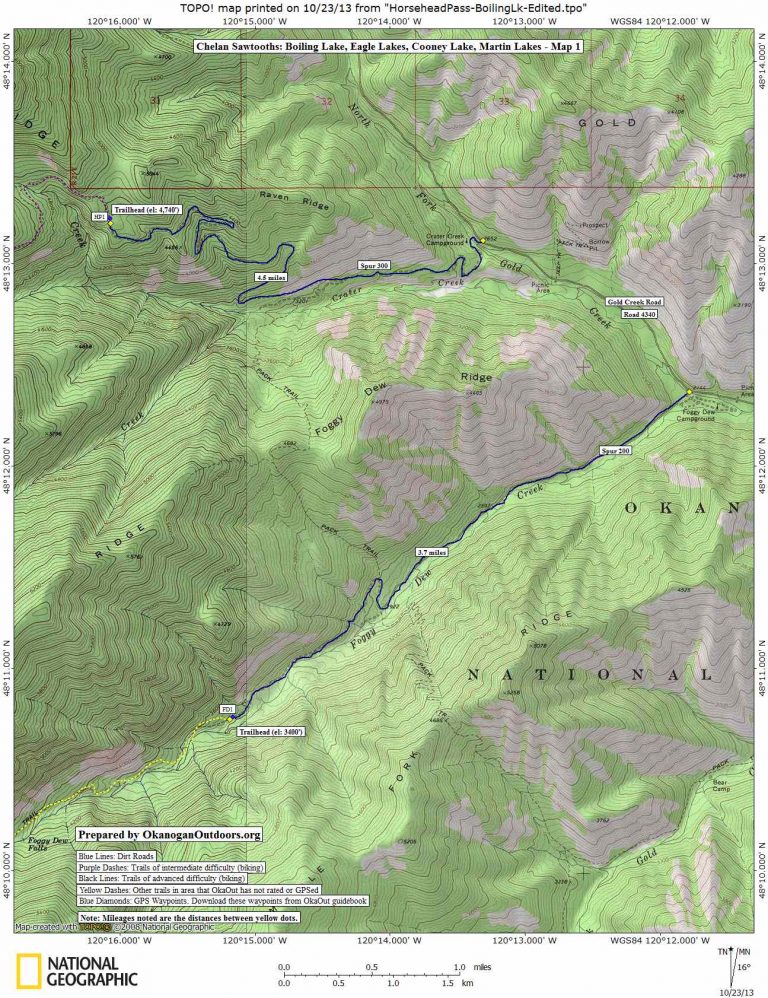
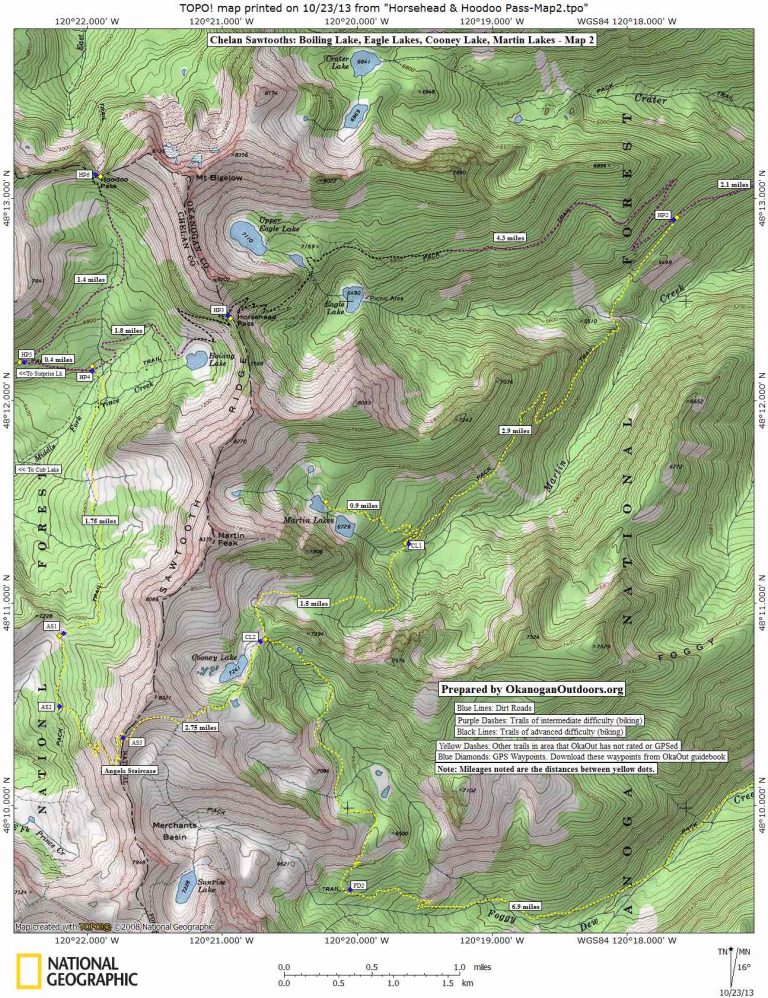
Maps: Map 1 shows access and start of different routes starting the Crater Creek Trailhead. Map 2 shows the high country.
MapMyRide. See this Angels Staircase GPS course made by Ray Birks.
Activities: Hiking, trail running, mountain biking.
Nearest Towns: Pateros and Twisp.
Skill Level: 2 (intermediate) for hiking, 3 (advanced) for mountain biking.
Fitness Level: 3 (advanced).
Distance: 20 miles, roundtrip, to Hoodoo Pass.
Elevation Gain: 5,000 vertical feet.
Recommended Season:. mid-July to September.
Access. Drive Highway 153 about 16 miles north of Pateros (about 14 miles south of Twisp). At milepost 16.8 turn, west on the Gold Creek Loop Road. After another 0.8 miles, turn left (west) on the Gold Creek Road, which is also called Forest Road 4340. After another 0.9 miles, go straight at a T-intersection, following signs toward the Foggy Dew Campground. After another 4 miles the pavement ends and at a fork in the road stay right, remaining on Road 4340. After another 1.5 miles, turn left onto Spur 300 and follow this 4.5 miles to the parking lot at the Crater Creek Trailhead (elevation 4,750 feet, no facilities, no permit needed to park).

Trip Instructions:
Horsehead and Hoodoo Passes:
–Head up the Crater Creek Trail for 0.7 miles. At the trail intersection for Crater Lakes stay left (lower) and continue climbing very well graded and buff trails.
–In another 1.4 miles, stay right at the trail intersection and keep climbing well-graded and well-maintained trails toward Eagle Lakes and Horsehead Pass.
–After another 2 miles of climbing, the trail starts having the occasional short segment that mountain bikers are likely to need to push even though most of the trail is ridable by strong cyclists with good uphill technique.
–As you approach the Eagle Lake area, avoid the spur trails going to Upper Eagle Lake and Lower Eagle Lake. Instead stay on the traversing trail that heads west toward Horsehead Pass and then switchbacks up steep, loose, and rocky ground leading to the pass. Most mountain bikers will want to carry the bike up the last mile to the pass.
–From Horsehead Pass, follow the trail downhill to Boiling Lake (0.9 miles). There are nice camps near the lake (pitch tents a few hundred yards from the shoreline).
–Another mile past (and downhill) from Boiling Lake is an intersection that also offers excellent camping. Going straight (downhill) gets you to Cub Lake in another 2.5 miles. Going left will get you to the Angels Staircase turnoff in 2.25 miles or to Deadman Pass in just under 4 miles. For this ride, fork rightish and follow the trail signed for Surprise Lake.
-The trail toward Surprise Lake climbs steadily but not overly steeply and reaches an intersection in 0.4 miles.
-Branch right and keep climbing toward Hoodoo Pass. This trail is smaller but wanders through beautiful meadows. If you’re on a mountain bike you’ll probably want to ditch the bike about a third to a half mile from the pass and walk (most of the final push to pass is too technical for most riders to want to descend).
-Return to the start by reversing the ascent.

Angels Staircase. Start from the Crater Creek Trailhead. In 2.25 miles, branch left on the trail signed for Martin Lakes and Cooney Lake. About 5.9 miles out, stay left and follow the trail leading to Cooney Lake (avoid the Martin Lakes spur). Shortly past Cooney Lake (about 8.5 miles out), prepare to hike up the long climb to the top of the Staircase (mountain bikers should consider using the vertical-stack bike carry shown in the picture below). After completing the climb (about 9.25 miles out), head down the rocky switchbacks of the Angels Staircase (cyclists shouldn’t be too proud to walk that which looks dicey to ride — this is a bad place to get hurt). At about 10.6 miles, merge with a trail heading north toward Boiling Lake. After about 12.7 miles, you’ll encounter trails leading to Cub Lake, Surprise Lake, and Boiling Lake — keep on the spurs going to Boiling Lake, which you’ll reach at the 13.7-mile mark. Beyond the lake, comes another sizable climb up to Horsehead Pass (14.5 miles out). Now get back to the start by following the Horsehead Pass directions (above) in reverse. Total distance of this loop: 24.2 miles.

Posted. This piece was first posted on 10/24/2013. On 9/16/2014, we added more information about riding/riding Angels Staircase as ‘The Staircase’ is a main attraction.
More Information: Evergreen Mountain Bike Alliance also has good information about this trip here
Leave It Better Than You Found It: This should be every outdoor user’s goal. Pick up trash left by others, pull noxious weeds along your route, disperse old fire rings (they encourage more fires), throw branches over spur trails and spurs between switchbacks (make it harder to do the wrong thing than the right thing).
Important Disclaimer: Treat this information as recommendations, not gospel. Things change, conditions change, and those contributing these reports are volunteers–they may make mistakes, fail to give complete information, or may not know all the issues affecting a route. So forget about finger pointing: If things go wrong, you are completely responsible for yourself and your actions. If you can’t live with that, you are prohibited from using our information.