By Molly Steere
Third time’s a charm. This was my mantra as my husband, Toby, and I pedaled out of the parking lot. We had been to the Ancient/Dusty Lakes area twice before, trying to finish out this new loop.
First attempt: We were a little over two miles in when I got a flat. I opened up my Camelback and found only Gu and toilet paper. Yikes. So I sucked back a Gu and let Toby take over. He patched the tube, pumped it up and *pop*, the valve broke. He conjured up another tube and started putting the tire back on and *snap* went his only tire lever. We managed to get the insanely tight tire back on using creative tooling, started pumping and *hiss*, there was a leak at the base of the valve. “I’ll meet you back at the car,” I mumbled as I pushed my bike past him. Great hike — would have been better without a bike.
Second attempt: I’m loaded with tubes and tools. At mile 3.0, we took a right instead of a left. It was beautiful single track down to the water but quickly became an ungainly game trail. Between the deep sand and the abrupt rocky sections it was more push than pedal. Fortunately, the trail looped us back up to the intersection at 1.8 miles and we limped back to the parking lot.
And so we found ourselves heading out a third time, trying to remain optimistic. Luckily, I tend to only remember the good parts of difficult trips and was looking forward to the stunning rock formations and river views. I wasn’t disappointed!
We finished out a great practice loop through scree, sand, and everything in between; all with a gorgeous backdrop alternating between the Columbia River and benched cliffs. You can do the loop by itself, or tack on a ride to the Gorge Amphitheater for more distance. Or, if you’re feeling particularly feisty, add this ride to the Ancient Lake–Fred-and-Frank’s Loop.
Attractions. Beautiful shrub sage country. Nice views over the Columbia River. Abundant bird life.
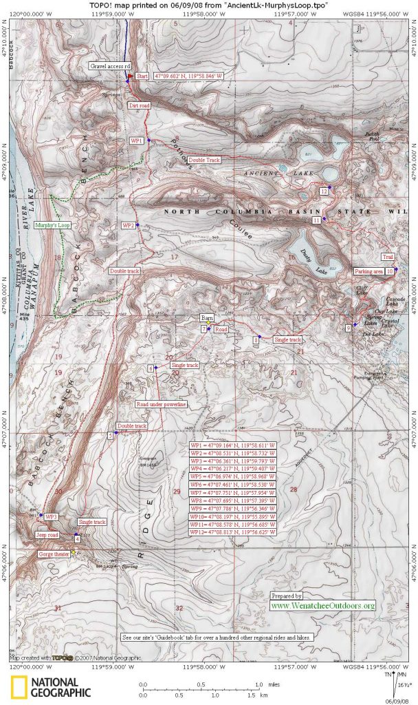
Access. From the west, drive Highway 28 about 2.5 miles past the Crescent Bar/Trinidad turnoff to milepost 25. At a rest area on top of the Trinidad Grade (several miles west of Quincy) turn right on 10 NW, immediately curve right and go around the back of rest area. In .4 miles, turn left on V Street. After .9 miles, go right (west) on 9th NW. Now just stay on 9th: after 0.5 miles it goes down a hill toward the Columbia River, at about 0.75 miles the road hooks left, at 1.1 miles the road turns into a good gravel road, and at 4.6 miles the good gravel road ends at a small parking lot with a sani-can and a gate across the road. Besides the sani-can, there are no facilities. Hikes/rides/runs start just past the gate.
Permits. Parking at the trailhead requires a Washington Department of Fish and Wildlife parking permit, which can be purchased anywhere fishing licenses are sold.
Distance. About 5.9 miles.
Elevation Gain. Less than 1000 vertical feet of total climbing.
Difficulty. While this ride is well suited to cross-country mountain bikes, the route has several loose, steep, rocky plunges and ascents requiring advanced/expert technique to navigate with such bikes. The majority of cross-country riders will find themselves walking short sections of this route. Use good judgment and dismount when things get dicey. If you have a ride with wider tires, bring it. You’ll like it in the soft sections.
Trip Instructions:
- Ride south along a dirt jeep road. This road can be very sandy and loose in summer. In 0.4 miles a single track spurs to the left. In 0.55 miles a double track branches off to the left and goes up the coulee leading to Ancient Lake—keep going straight on the main road.
- Mile 0.75. Turn right onto single track.
- Mile 0.9. Drop into a draw and follow the trail down a scree-covered slope. Remain loose and maintain your speed.
- Mile 1.5. Final steep descent onto the bench. The next 0.3 miles is the softest. The sand is a leg-burner so stay smooth and fluid. You might want to lock out your shocks if you have the option. Fight temptation and stay on the trail regardless of how hard it gets.
- Mile 1.8. Take a left up the ridgeline before the trail drops down to the river. The trail is a little faint, but it becomes more robust shortly. If you choose to go down to the river at this point you can follow a game trail along the water (gorgeous, but much better suited for hooves and sneakers than wheels). As you head south on the ridgeline trail paralleling the river keep on your toes and look for rocks. They jump out at you and try to knock you off your ride or drop your speed. The trail fades out every once in awhile so check the horizon often.
- Mile 3.0. Take a left at the trail intersection and head toward the cliffs. After turning left there’s a quick hike-a-bike segment up a short rocky ascent. The trail to the right (dropping down to the water) is the same trail you encountered at mile 1.8.
- Mile 3.6. Intersect the double track jeep road. From here you can either go left and head north back to the parking lot for a 5.9 mile loop, turn right and ride the double track down to the Gorge Amphitheater and back for a 10+ mile ride, or return to the car taking detours on the out-and-back double-tracks leading to Dusty and/or Ancient Lake.
Or, if you’re feeling strong, head toward the Gorge and complete the Ancient Lake–Fred-and-Frank’s Loop for a wild ride.
Season. Best in spring and late fall after wetting rains. The soil around here gets very loose and sandy in summer…and it gets reeeal hot, too. But the area is one of the region’s fun zones in those shoulder seasons when our mountain zones are still too snowy, too rainy, or too muddy. Some years, this area is even surprisingly hospitable in the dead of winter.
Hazards. Heat in summer. Rattlesnakes in late spring, summer, and early fall. Rocks at all times.
Uses. Hiking, mountain biking, trail running, fishing, and horseback riding are allowed; motorized vehicles are not.
Ownership. The area is managed by the North Columbia Basin Wildlife Area. A number of areas in the WenatcheeOutdoors guidebooks (e.g., Ancient Lakes, Swakane Canyon, Colockum and Chelan Butte) are on Washington Department of Fish and Wildlife lands. Hunting and fishing licenses help support these properties and other recreationalists are likely to find these lands being hunted throughout the fall. On some of these properties you’ll encounter upland bird hunters into January.
Maps. See our topo. Ancient and Dusty lakes are on the Babcock Ridge 7.5-minute USGS topographic map and the south portion of the ride is on Evergreen Ridge. 7.5-minute topo.
Other. This route also makes an excellent hike and trail run.
Trip Reporter: Molly Steere, June 2008
Leave It Better Than You Found It. This should be every outdoor user’s goal. Pick up the trash others have left behind, pull noxious weeds along your route, disperse fire rings found at campsites (they encourage more fires), throw logs and branches over spur trails and spurs between switchbacks (make it harder to do the wrong thing than the right thing).
Disclaimer. Treat this information as recommendations, not gospel. Things change, conditions change, and those contributing these reports are volunteers–they may make mistakes, fail to give complete information, or may not know all the issues affecting a route. You are completely responsible for your decisions, actions, and safety. If you won’t accept that responsibility, you are prohibited from using our information.