Attractions: One of the few trails that are open to mountain bikes and closed to dirt bikes keeps the peace about the area. It gets little use but is still maintained and in excellent condition. Fantastic climbs will pay off with some spectacular views of the Cascades and Glacier Peak. Your efforts will be rewarded.
Skill: 3 (advanced)
Fitness: 3 (advanced)
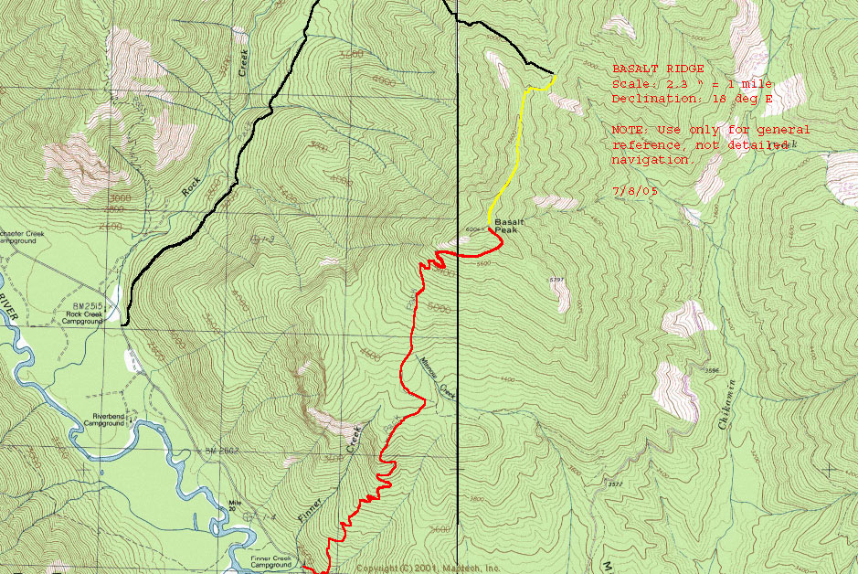
Maps. See map below for more info.
Access: Take US 2 to Coles Corner 19 miles east of Stevens Pass. Turn north on SR 207. At 4.3 miles cross the Wenatchee River and take the right hand fork on Chiwawa Loop Road. Continue for 1.3 miles and turn left on FS 62 the Chiwawa River Road. Follow the pavement for 11.1 miles at which point the road turns to gravel for another 4 miles. You will drive past the Basalt Ridge Trailhead on the way to the Rock Creek Trailhead to begin the ride.
Distance: 13 miles
Trip Instructions submitted by Ray Birks (July 12, 2010)
We headed out to the Lake Wenatchee/Plain area to tackle the Basalt Peak ride. We were excited because supposedly this is the only trail in the Lake Wenatchee area that does not allow motorcycles. Rumors of a trail that has a distinctly different feel to it than others in the area were in the forefront of our minds.
We parked at Finner Creek Campground about 13 miles up Chiwawa River Road and continued on our bikes up the road about 2 miles to the Rock Creek Campground and our trailhead. Finner Creek has three camping spots, an outhouse, and water. There is a trail that parallels the road from Finner Creek to Rock Creek if you want to ride trail the whole way. To access this trail start up the Finner Ridge Trail and there is a junction in about 50 yards where you’ll go left. For the sake of speed we took the road. Make sure to register at the trailhead to let the powers-that-be know that mountain bikers are trail users too.
Our goal was to ascend the Rock Creek Trail to the Rock Creek Tie Trail and to descend the Basalt Peak Trail back to our car. The total elevation on the climb is over 3,500 feet in about 7 miles. The descent is less as it takes a more direct route to the valley floor. It took us 3 hours of moderate-paced climbing to reach the summit.
-
The first 100 yards of trail was moderately steep but then the pitch settled down for the 2.2-mile climb to Rock Creek Tie. Along the way there were three creek crossings and one landslide that had been repaired but was not rideable. The riding on this section was pleasant with a several steeper sections here and there. Overall it was generally an intermediate climb on a nice trail, albeit a bit brushy at times. It is forested and there are not too many rocks and roots.
-
A little ways after the third creek crossing, we turned right on Rock Creek Tie and things started to get steeper. There were 13 switchbacks from here to the saddle at 5,200 feet and this trail climbed almost 2,000 feet in about 2 miles. Most of this trail can be ridden but there are a few brushy or steep spots that will require you to get off and do some short hike-a-biking.
-
At the saddle, you have an option to go left to Garland Peak but we turned right onto Basalt Peak Trail. In about 100 steep yards there was another junction. To get to the summit of Basalt Peak (5,700 ft) continue straight. If you turn left you can ride 1.5 miles down a steep trail that will take you to Chickamin Rd., about 4 miles up from Chiwawa River Rd.
-
The riding from the junction up to the peak is the hardest on the route, but when you’re that close to the summit and you can almost taste your epic downhill it usually doesn’t matter how steep the last little bit is. Another junction will come up pretty quickly but stay left and continue to ascend. My memory of this last 2 miles was that it was more mountain than biking. You’ll probably push about 1/3 of the way and ride 2/3 of the way up some rocky trail sections but the views start to open up and in about 30+ minutes you’ll reach your destination. There are a few false summits and a few loose, rocky stretches but you’ll finally come to another junction where your descent trail starts to head down to the left.
-
At this point you can start heading down or take the right turn and, about ¼ mile later, you’ll see the splendid sights of the Glacier Peak Wilderness and the Chiwawa River Valley.
-
Now you have a few options. You can retrace your steps and bomb back down Rock Creek Tie and Rock Creek or return to the nearest junction and take a right. This was our goal and it proved to be worth all that uphill sweat. You’ll speed down this great trail for about 30-45 minutes without doing much pedaling. There were over 25 switchbacks to navigate, all of which are rideable.
-
This trail starts out at the top with a little loose rock but the farther you descend the better the trail gets. Before you know it you’ll find yourself at the bottom wearing a perma-grin. The lower part is fast and covered with pine needles and has the occasional root but is remarkably rock-free. You start to notice the absence of the normal rutted-out, dusty sections and whoop-dee-doos that normally accompany a trail that allows motorcycles.
-
About halfway down,there is a spur to the right that takes you to a viewpoint. Shortly after that another spur to the left that takes you to Chickamin Rd. 6210. Both of these junctions have signs. Avoid these unless you want to catch the sights or add Minnow Creek/Chickamin Ridge to your adventure. Our ride stayed on the main trail and continue down the 4+ miles to Finner Creek.
These trip Instructions were previously listed on mtbr.com. You can find some older reviews of the route from mtbr.com here.
- The suggested route climbs up Rock Creek Trail 2.5 miles. It begins with a strenuous climb but settles down after a couple hundred yards. The trail is fairly smooth and appears to see little use except from a few horses and hikers. There are several minor creek crossings as the trail wanders through deep forest.
- At 2.5 miles take the right hand fork on the Rock Tie Trail #1538. While smooth, this trail switch-backs up to the top of Basalt Ridge. It is a vigorous climb. Elevation gain is 3500 feet in 5.2 miles. Except for a couple of poorly designed switchbacks it is all ridable.
- At the top of ridge you come to the intersection of the Basalt Pass Trail 1530 and the Basalt Ridge Trail 1515. The Basalt Pass Trail descends very steeply to the Chihamin Road FS 6210. At this point my group was into the ride two hours.
- Take a right on the Basalt Ridge Trail which wanders along the south side of the ridge just below the top. There are several decent views of the Chikamin drainage.
- After two miles of climbing, somewhat strenuous, you come to the intersection of Minnow Creek Trail 1539 and a trail going off to the right that purportedly goes to a viewpoint. The sign at this trail intersection had long ago been vandalized. The Minnow Creek Trail drops to The Chikamin Road, and like Basalt Pass can be tied into a loop via Minnow Ridge Trail 1524 back to Chiwawa Road.
- We explored the unmarked trail to the right but since it drops sharply after a couple hundred yards turned around and proceeded on Basalt Ridge Trail.
- After climbing sharply from this trail junction you eventually crest the ridge. At this point there are spectacular views of Glacier Peak and the North Cascades. Many parts of this section will not be ridable to all but the most experienced riders.
- As the trail begins to descend, you come once again to an unmarked trail intersection. The right hand fork goes through the trees for 200 yards to a nice rock outcropping and more great views of the mountains and Chiwawa valley. The descent down the Basalt Ridge Trail from the top makes all the climbing worthwhile.
- In just 3.4 miles you lose 3500 feet of elevation on virtually virgin single track. On our trip we saw no evidence of bike use after leaving the Rock Creek/ Rock Tie intersection. This section back to the road showed no use by anyone at all. This was a big chain ring high speed decent that put us back on the road in 35 minutes. The trail contains many switchbacks, but is in superb shape. At the bottom it is less than two miles back to Rock Creek.
More info. You can also see this 2015 review from the Evergreen Mountain Bike Alliance website here.
Leave It Better than You Found It. This should be every user’s goal. Pick up trash left by others, pull noxious weeds along your route, throw branches over unwanted spur trails, etc.
Disclaimer. Treat this information as recommendations, not gospel. Conditions change and those contributing these reports are volunteers–they may make mistakes or not know all the issues affecting a route. You are responsible for yourself, your actions, and your safety. If you won’t accept that responsibility, you are prohibited from using our information.