

Attractions. This route is a non-nonsense ascent and descent of one of the higher peaks flanking Highway 2. The access is easy and if you don’t want to waste time touring flat terrain to reach skiable slopes, this is a good tour. Right from Highway 2 you get down to business and climb over 4,000 vertical feet to the summit of this peak. The start of the route looks down on the highway and is a bit noisy. At about the 5,000-foot level, however, the orientation of the ascent changes and the sub alpine forests and views of the surrounding peaks is well worth the initial blahs. The upper basin from the summit of Rock Mountain down toward Rock Lake also has a wide variety of slopes to yoyo. Finally, Rock Mountain is also the springboard for a strenuous but memorable day of traverse of Mt. Howard and Mt. Mastiff (see our map).


Elevation Gain. 4,200 vertical feet. Distance. About 10.5 miles round trip from Highway 2
Skill: 3 (advanced) Fitness: 3 (advanced)
Access. Drive 26 miles west of Leavenworth on Highway 2 and park at milepost 73.2 on the north side of highway just before the snowed-over road leading to the Rock Mountain Trailhead. The highway’s shoulder is plowed extra wide here and fair-weather parking has been allowed as of 2007. However, if you don’t want your Subaru turned to scraparu, avoid parking here when plowing or snow blowing is taking place (i.e., during or after a snowstorm).
Hazards. There’s plenty of avalanche hazard along this route–in the wrong snow conditions you might find yourself drowning in snow. Literally. It’s up to you to decide when the route is sane or stupid.
Trip Description:
-
- From Highway 2 (elevation 2,640) forget about snowed-over road and follow a true bearing of 50 degrees to the summer trailhead.
- Now follow a true bearing of 336 degrees to the 5,000 foot level. This is steep ground and you’ll need to maneuver between many boulders, clifflets, and small obstacles. The best mode of travel here will be snow dependent –sometimes you can skin up, sometimes it’s easier to pack the skis and boot up.
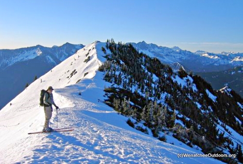
- Next, follow a true bearing of 329 degrees into the alpine zone. For much of this leg you’ll stay on the crest of a ridge, but in one or two places the ridge crest is not easily passable and you’ll traverse below the crest on the east-facing slopes and then regain the ridge crest.
- At an elevation of 6,200 feet, head west and gain the upper south-facing ridge of Rock Mountain. Once on this ridge, head north to the 6,840-foot summit.

Descent. There are more lines than you’ll have energy to ski in the cirque below the peak. Yoyo a few. On the final descent, don’t drop too deep into the forest before working your way over to your ascent route. Below the 5400-foot level ski down in the general vicinity of your uptrail. Alternately, follow the traverse route noted on our ski map and eventually return to Highway 2 by skiing the slopes south of Merritt Lake.
Permits. Technically a NW Forest Pass is needed to park at the trailhead
Map. See our ski map below or consult USGS map 7.5-minute: Mount Howard.
Trip Reporter. Andy Dappen, First report: February 2007. Last updated November 2015
Leave It Better Than You found It. This should be every user’s goal. Pick up trash left by others, pull noxious weeds along your route, disperse old fire rings, throw branches over unwanted spur trails…
Disclaimer. Treat this information as recommendations, not gospel. Conditions change and those contributing these reports are volunteers–they may make mistakes or not know all the issues affecting a route. You are responsible for yourself, your actions, and your safety. If you won’t accept that responsibility, you are prohibited from using our information.

