
Photo: Icicle Ridge delivers big-screen view from Icicle Ridge of Stuart (right) and Colchuck (left).
After a brutal 4,800-foot climb up Fourth of July Creek, you reach Icicle Ridge with its big-screen views of the nearby Stuart Range and it’s long views of other Cascadian peaks. After the uphill pain (it will take most people four or five hours to push/carry a bike up) comes a massive 5600-vertical-foot descent. The descent is totally ridable by skilled freeriders. Cross-country riders, meanwhile, will find some of the rocks, ruts, and bush sketchy. Such riders will sometimes find themselves wondering whether they should walk the sketch and hurt their pride or ride the sketch and risk snapping a collar bone. Decisions, decisions.
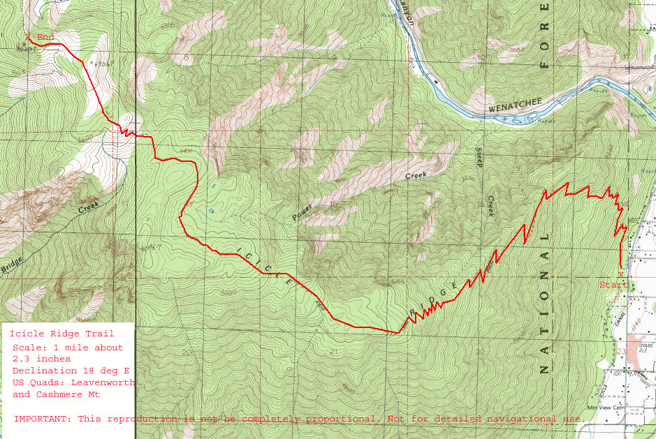
Maps: See maps below for more information.
Note: use ‘Print Preview’ before printing to properly scale this map to a full sheet of paper.
Activities: Mountain Biking.
Nearest Town: Leavenworth
Skill Level: 3
Fitness Level: 3
Distance: 20.00 miles (32.18 KM)
Elevation Gain: 5000 Feet (1523 Meters).
Access: From Icicle Junction on the west end of Leavenworth, drive south on the Icicle Creek Road (on the western edge of Leavenworth). At 1.4 miles you’ll reach the Icicle Ridge Trailhead on your right and most parties will leave a shuttle vehicle here (NW Forest Pass needed) and then carry on. At 8.5 miles you’ll pass the Eightmile Road and Bridge Creek Campground. Continue onward and a 9.4 miles, you will reach a small paved parking area and the trailhead for Fourth of July Trail No. 1579. The parking area requires a permit and can handle roughly 10 cars if users park conscientiously.
Uphill Instructions: about 0.25 mile after you start up the trail, you will cross Fourth of July Creek–the last source of water on the hike. Continue up the tight switchbacks until a mile before the crest of the ridge, where the trail will begin to traverse to the east. There is a spring at about 5400 feet, though there may not be water in late summer. At 6,800 feet, the trail reaches the ridge crest and intersects with Icicle Ridge Trail. Take a left on this path if you want to climb the final 0.25 mile to the site of the old lookout (which, obviously, has a view worth the side trip.) A right at the aforementioned intersection starts the long downhill. Most of the uphill will be hike-a-bike, with good technique and great lungs a strong rider might be to ride a quarter to a third of the uphill.
Downhill Instructions: After turning right onto the Icicle Ridge Trail, follow the trail downhill (there will be a few short climbs), and hang on. There’s no place to really lose your way as you head downhill in a southeasterly direction but use Map 2 just to comfort yourself that you’re doing things right. If you survive the ride you’ll reach the Icicle Ridge Trailhead that’s about 1.4 miles south of Icicle Junction (Leavenworth) at the 1200-foot level. If you’re a downhilling dude, you’ll want more. If you’re a cross-country rider, you’ll probably be darn happy the downhill is done.
Returning to the start. Either use a shuttle vehicle left at the lower trailhead, or ride 8 miles up the Icicle Road to the Fourth of July Creek Trailhead.
Additional Information: Bring plenty of water this ride–you won’t find a lot along the way.

Photo: This is a great autumn route when vegetation is in color, temperatures are not so severe, and when you won’t be sucking as much water.
More Info/Links: See this MtnBikeReview trip report from July 2013. Evergreen Mountain Bike Alliance also has good information about this trip here
Fees/Permits: Northwest Forest Pass needed to park at the trailheads.
Dates and Updates: This trip report was first created in the summer of 2007 and was last updated July 26, 2013.
Leave It Better Than You Found It: This should be every outdoor user’s goal. Pick up trash left by others, pull noxious weeds along your route, disperse old fire rings (they encourage more fires), throw branches over spur trails and spurs between switchbacks (make it harder to do the wrong thing than the right thing).
Important Disclaimer: Treat this information as recommendations, not gospel. Things change, conditions change, and those contributing these reports are volunteers–they may make mistakes, fail to give complete information, or may not know all the issues affecting a route. So forget about finger pointing: If things go wrong, you are completely responsible for yourself and your actions. If you can’t live with that, you are prohibited from using our information.