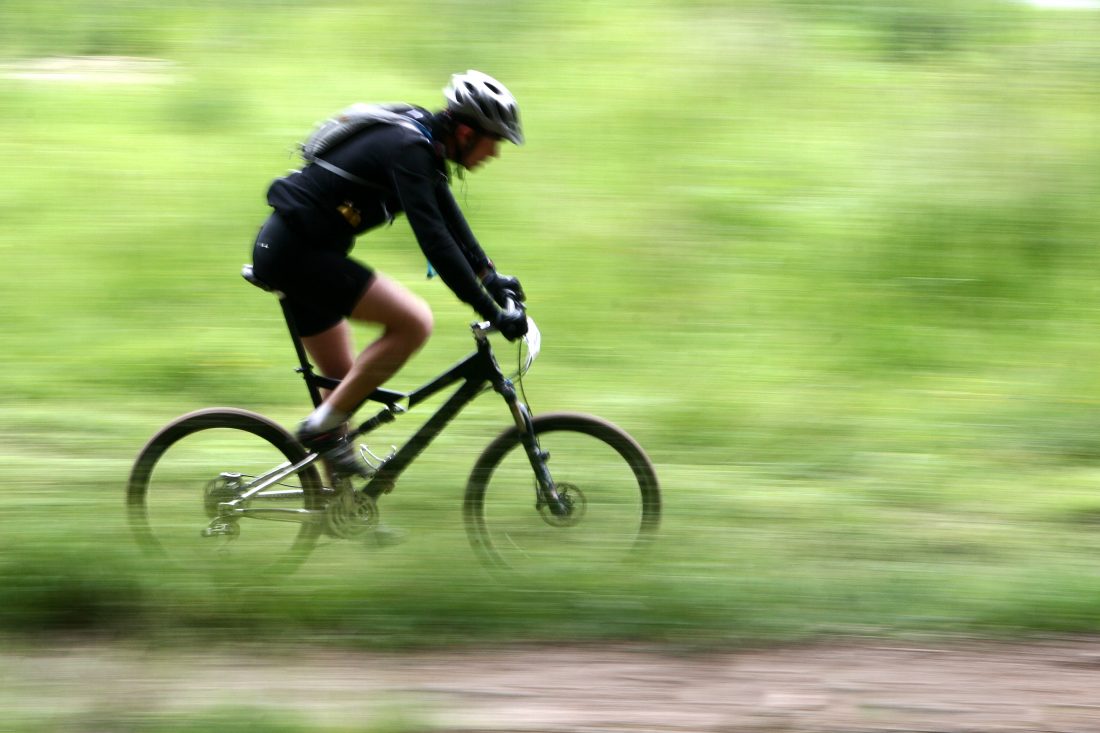

Often described as one of the premier rides in the state, the buff trail of this ride features beautiful pine grass and ponderosa pine forests, creek crossings, steep sided canyons… Our link below has nice descriptions of what the ride encompasses.
Activity: Mountain Biking, trail running, hiking.
Nearest Town: Wenatchee, Cashmere
Skill: 2 (intermediate) to 2+ (advanced intermediate). Overall this is a moderate trail but there are several corners and a few traverses where too much speed or poor bike handling could cause real harm.
Fitness: 3 (advanced)
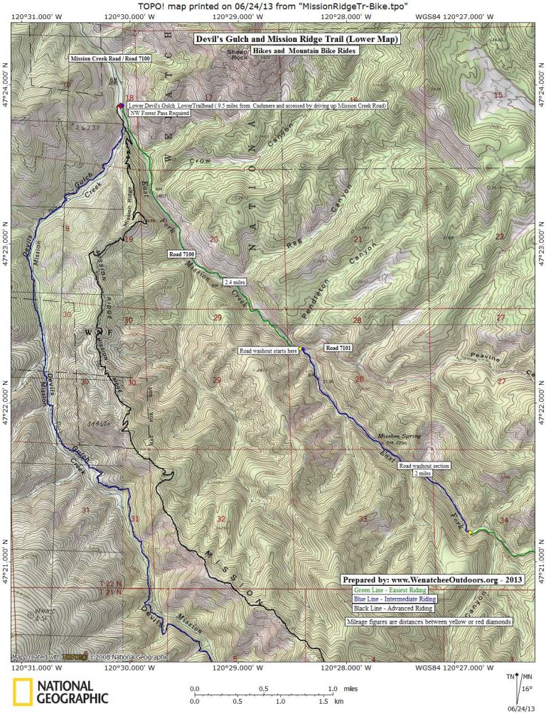
Distance: 23 miles round trip between the upper and lower trailheads
Elevation Gain: 3,300 feet.
.JPG)
Photo: The fires of late summer in 2012 torched some of the forests in the area and just burnt the underbrush in other places. Portions of the trail had lots of deadfall that needed to be bucked out. There will be lots more deadfall spanning the trail in years ahead as wind and snow storms bring down dead snags.
Maps: View our maps below for more information.
Use ‘Print Preview’ before printing to properly scale this map to a full sheet of paper. This schematic map is also useful.
Access:
- From Wenatchee, reach the upper trailhead by driving up Squilchuck Road toward Mission Ridge. Follow the Squilchuck Road 1 mile past Squilchuck State Park and turn right on Forest Road 9712 (Beehive Reservoir Road). Drive this road about 4.3 miles to the Devil’s Gulch Upper Trailhead.No permit needed to park here.
- From Cashmere, exit Highway 2 at the westernmost Cashmere stoplight. Cross the bridge into Cashmere and at the main intersection in town (flashing light) go straight (you’re on Division Street). In a few hundred yards the road bends to the right around the schools and becomes Pioneer Avenue. Shortly after this bend, turn left on Mission Creek Rd. Go roughly 0.5 mile and turn right at the T intersection. Cross Mission Creek and turn left at the next road, which is the continuation of Mission Creek Road. Now drive 6.2 miles to a Y in the road near where the pavement ends. Near the end of pavement and around this Y in the road, the property bordering the road is private, strewn with dead cars and junked appliances. No trespassing signs are visibly posted making, it seem as though you can’t drive the road. Ignore them. Take the left branch and follow Road 7100 along Mission Creek for about 2.75 miles to the lower Devils Gulch Traillhead (el 1,750 feet). (May 2012 update: You can no longer drive directly from Cashmere to the Lower Trailhead because Road 7100 is washed out 2 miles downstream of the trailhead. There is space on the left side of the road near the washout to park 10 to 12 cars — no signage indicates a NW Forest Pass is needed to park here.)
- Additional driving info as of May 2012: Formerly it was possible to shuttle easily between the lower and upper trailheads by parking at either end and using Road 7100 (East Fork of Mission Creek) and Road 9712 (Liberty-Beehive Road). Now Road 7100 is washed out a few miles below the Lower Trailhead as well as a few miles above the Lower Trailhead. The washouts eliminate the possibility of doing vehicle-assisted shuttles for the uphill portion of this ride. The road system can still be ridden on a bike, however, and makes a logical ascent route.
Trip Instructions– Ascent
- From the Lower Devil’s Gulch Parking you can ride up the trail (use the descent directions in reverse). This is a slower but scenic and very ridable way to the top. Because most people ride downhill (often carrying a lot of speed) the ride up the trail is better saved for weekdays or early-morning/late-afternoon on weekends.
- Most people actually reach the top of the upper trailhead by riding up Road 7100.This is faster and avoids collision potential with downhill riders. From the lower trailhead, ride up Road 7100 miles 2.4 miles until hitting the lower part of the washout that took out the road. At this point Road 7101 fades slightly left and eventually connects with Number 2 Canyon and all the trails around Twin Peaks. However you want to hook right here, drop down and over a small creek, and then keep riding up the East Fork of the Mission Creek drainage. About 9 miles miles from the lower lot, remain on Road 7100 by going right at a 5-way intersection. In about 0.75 miles Road 7100 ends, turn right on Road 9712. About 11.4 miles from the lower lot, turn off Road 9712 into the parking lot for the Upper Trailhead (elevation: 5,000 feet).
Trip Instructions– Descent:
–Reset your odometer at the Upper Devils Gulch Trailhead. Start off along an old road bed. The trail soon cuts into the woods.
–Mile 3. Trail intersection with the Mission Ridge Trail. For this ride, go straight to stay on the Devils Gulch Trail. Going left takes you uphill to the Mission Ridge Trailhead and this is a difficult trail to ride in this direction (much better for descending). Going right will get you on the lower portion of the Mission Ridge Trail (this is a very good ride but is more difficult, technically and physically, than Devils Gulch).
–Mile 4. The trail starts making a series of switchbacks as it drops down into the valley formed by Mission Creek.
–Once down in the valley, the trail parallels Mission Creek. It crosses some sidecreeks and actually crosses Mission Creek a few time.
–During the last few miles of the trail a few spur trails (e.g., Red Hill Trail and the trail down Mission Ridge) join your trail. Just keep following the Mission Creek drainage downhill.
–Mile 12.3. Reach the lower trailhead.
Fees/Permits Needed:
A Northwest Forest Pass is needed to park at the lower trailhead but, as of 2013, is not needed at the upper trailhead.
More Info/Links: Click here to read a good Seattle Times article about this ride. Evergreen Mountain Bike Alliance also has good information about this trip here. Finally, this link at Gene’s BMX has lots of info, pictures, and links that pertain to this trail.
Condition Updates:
–May 2009. The Mission Creek Road to the Lower Trailhead washed out over the winter and won’t be repaired until 2010. The Forest Service is telling people to park at Sand Creek.
–July 19, 2009 update. Cashmere resident, Larry Glickfeld, reports that getting across the Mission Creek washout by bicycle is now quite easy. “The creek is down far enough that it’s a simple walk, and much of the washout is actually rideable. Parking is another issue. Today numerous vehicles were parked just north of the road closure, despite the ‘No parking beyond this point’ sign at the Sand Creek junction, about 1/2-mile to the north. Upon my afternoon return I noted that they all had red ‘Warning’ tags on the windshield — actual ticketing may happen anytime. The recommended parking is at the Sand Creek/ Red Devil Trailhead, about 1.1 miles west of the Sand Creek/ Mission Creek junction. Forest Service permits are required for parking there, and this adds a total of perhaps 8 miles — 4 miles each way– to a Devils’ Gulch loop ride, albeit the extra mileage is all on well-graded, flat to low-sloped gravel road.”
–May 2012 update. Formerly it was possible to drive between the upper and lower trailheads by driving up Forest Road 7100 and connecting with the Beehive Road (Road 9712), but a few mile section of Road 7100 washed out. Driving this route is not possible now. This has significantly reduced the traffic on the trail because you can’t easily shuttle bikes by car. We think this is a good thing — it’s better for health, the environment, and sustainable trail design if people pedal up what they ride down.
–July 2, 2013 update: A particularly fierce downpour on June 29 resulted in some flash floods that made a mess of the stream crossings on the Devils Gulch Trail. At least 4 stream crossings got washed out by this big rain — one of those crossings has a 50 yard by 50 yard pile of debris that needs to be carried over. In the weeks ahead the Evergreen Mountain Bike Alliance will be organizing a trail party to clean-up the stream crossings and other deadfall that came down on the trail.
–October 31, 2017 update. The Women With Altitude Hiking Group reported the drive to the Lower Trailhead is in fine condition with the normal mess of cars, junk, and trailers when driving past Little Appalachia a few miles before the trailhead. There are a lot of downed trees (blow downs) along the first few miles of the trail upstream of the Lower Trailhead. The trail is also getting quite entrenched and U-shaped from dirt bikes and mountain bikes using the trail, making it a little awkward to walk.
Don’t Ride Soft /Wet Trails. Please stay off trails and when they are wet/soft and you’re leaving wheel ruts that are deeper than 1/4 inch (these become grooves for water and greatly accelerate erosion). A rule of thumb to consider: Could 100 people ride the trails in this condition without messing up the surface? If the answer is ‘no’ please turn around.
Don’t Just Be a User. These trails need frequent maintenance and much of the work is done by volunteers. If you use this trail, help maintain it. To join trail maintenance parties, contact Das Rad Haus in Leavenworth (509-548-5615) or Central Washington Chapter of Evergreen.
Leave It Better Than You Found It: This should be every outdoor user’s goal. Pick up trash left by others, pull some noxious weeds along your route, throw branches over spur trails that are not part of the formalized trail system (make it harder to do the wrong thing than the right thing).
Important Disclaimer: Treat this information as recommendations, not gospel. Conditions change, and those contributing these reports are volunteers–they may make mistakes or may not know all the issues affecting a route.You are still are completely responsible for yourself, your decisions, and your actions. If you can’t live with that, you are prohibited from using our information.
.JPG)
Even though fires swept through here in 2012, burnt areas are greening up fast. The devil may try to suppress it, but life is resilient.