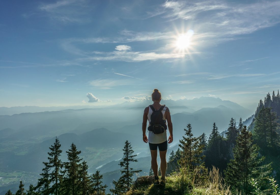

Photo: A hiker reaches the summit of Miller Peak.
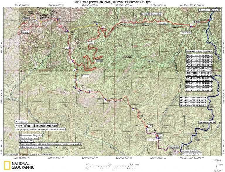
Miller Peak west of Old Blewett Pass offers hikers, mountain bikers, snowshoers, and skiers outdoor opportunities all year long. The County Line Trail is a scenic, undulating trail for normal hikers and burly mountain bikers that provides ever-changing views as you move from knoll to knoll along a long ridge leading to toward Miller Peak. Meanwhile, the North Fork of Shaser Creek provides mountain bikers and winter recreationalists easier access to the peak along old logging roads that eventually intersect the southeast ridge of the summit pyramid. Regardless of the route taken, the summit of Miller Peak (6,402′) is a stunning viewpoint with up-close views of the Enchantments and the Stuart Range.
Maps: See our topo map below for more information. Also see Green Trails # 210 (Liberty).
Note use ‘Print Preview’ before printing to properly scale this map to a full sheet of paper.
 Activity: Hike or mountain bike the County Line Trail. Mountain bike, snowshoe, or backcountry ski the North Shaser Creek option.
Nearest Landmark: Blewett Pass
Skill Level: 2 for hiking. 2 for mountain biking Shaser Creek to the interesection with the County Line Trail. 3 to mountain bike the County Line Trail (expect to hike the bike in quite a number of uphill pitches and maybe a few downhill pitches). 2- to mountain bike North Shaser Creek until it intersects the County Line Trail. 2+ or 3- for snowshoeing the peak, 2+ for skiing the peak.
Fitness Level: 3 for all endeavors. However you do it, it’s a fairly long day.
Distance. For the County Line Trail the roundtrip distance is 12 to 13.5 miles (if you have a high-clearance vehicle) or 15 to 16 miles if you park at Old Blewett Pass. For the North Shaser Creek approach the distance can range from 13 miles roundtrip for winter travelers who use the cross-country variations noted on our map to 21 miles roundtrip for mountain bikers sticking entirely to roads and trails leading to the top.
Elevation: The County Line Trail starts at about 4,300 feet and ends at 6,400 feet but has lots of ups and downs along the way — the round trip hike has a total of about 2,700 feet of gain. Outings up North Shaser Creek gain 3,800 feet from start to summit but don’t have that same undulating quality — you simply go up as you head to the summit or down when you return.
Recommended Season: Fall, early summer, spring. This could be a pretty hot hike in the middle of the summer. Take lots of water, as there is none to be found on the trail.
Access. Access to the County Line Trail is a bit confusing and maps, while helpful, are difficult to interprest because there seem to be more roads out there than the maps depict. These instructions should help:
- Drive Highway 97 south of the Big Y Junction about 12.5 miles , take a right take a right on the Scotty Creek/Blewett Pass Road #7320 and follow the Old Blewett Highway about 6 miles to the top of Old Blewett Pass (paved all the way).
- At the pass, turn right (west) on a steep dirt road with signs reading: #7322-200 and Trail 1226. In 0.15 miles, stay to the left on road signed 7322-200. In another 0.25 miles there will be a road heading uphill to the right with no sign. Pass this option and keep going straight. In about 75 feet, there’s another road to the right. Choose this road and start heading gradually down hill for about 0.5 miles to an intersection at Waypoint 1.
- At Waypoint 1, take a sharp left on a smaller, rougher road (#7322-270) and in 100 yards (downhill) reach a little saddle (Waypoint 2). This is a good place to park. If you have a higher clearance vehicle and don’t mind some bushes rubbing against the side of your car, you can drive another half mile by going straight (uphill) for 50 yards and then turning right on a road noting that you’re headed to Trail 1226. Follow this road uphill (steep, rocky, and narrow) for 0.5 mile and park in a little saddle wide enough for cars to turn around (Waypoint 3).
Access for North Shaser Creek: Drive Highway 97 south of the Big Y Junction about 12.5 miles, take a right on the Scotty Creek/Old Blewett Pass Road #7320 and follow this 0.8 miles to where Road 7322 splits off to the right. Park near this split.

Photo: Miller Peak a short distance below the long traverse sapnning its sourth face.
Trip Instructions for County Line Trail:
- From the higher parking area (Waypoint 3), follow a bushy road that’s flat or even slightly descending for 0.3 miles to another little saddle with a sign noting the County Line Trail #1226.
- Follow the trail as it zig zags up hill. In the next three quarters of a mile you’ll intersect some old logging spurs. Old signs will indicate where the trail leaves the road and heads back into the woods.
- About 2.75 miles from the car (Waypoint 8), you’ll intersect the Teanaway Ridge Trail (#1364) which forks off to the left. For this trip, go right and walk north toward Miller Peak.
- Shortly after this intersection you’ll lose significant elevation as you drop down to a pass (Waypoint 11) where the road from North Shaser Creek intersects the County Line Trail.
- The trail heads north on or near the ridge crest for another 1.5 miles to Waypoint 14 and then, near the 5,700 foot level, starts a long traverse across the entire south face of Miller Peak.
- You can take this tedious, flat traverse for 1.3 miles to where it intersects a trail on the southwest ridge of Miller Peak, then turn right and follow the ridge trail 0.4 miles to the summit. Or, you can start that tedious, flat traverse and after 0.4 miles head straight uphill to the summit, gaining the southeast ridge at Waypoint 15. This cross-country route is steep and a bit loose, but much faster to ascend than using the trail.
Trip Instructions for North Shaser Creek Options:
- Follow Road 7322 away from the Old Blewett Highway. Along the way there will be a number of spur roads splitting off but stay on Road 7322, which for the first three miles heads west following North Shaser Creek.
- If you’re mountain biking, stay on Road 7322 as it climbs up the North Shaser Creek watershed. After 7 miles the road crests out at a pass and intersects the County Line Trail at Waypoint 11. Follow the trip instructions above for the remainder of the route leading to the summit.
- In winter when there is enough snow to cover the off-road brush and debris, skiers and snowshoers can leave Road 7322 after 3.4 miles (Waypoint 19), and follow the ridge system marked on the map to the County Line Trail at Waypoint 13. From here, winter travelers will have the least avalanche exposure if they roughly follow the trail and ridge to Waypoint 14 and use the East Ridge to reach the summit.
Cons/Hazards. The trail guides all indicate this trail gets lots of use by motorized vehicles. We did the hike on a Saturday in late June and saw 4 mountain bikers and 2 motorcycle riders. Not isolation, by any means, but still a pleasant trail with great views. This area is also a popular deer hunting area in late October and early November. Don’t wear your antler hat if you go during this time of the year.
Additional Information: Miller Peak can be accessed in many ways but the first half of the County Line Trail is not that well used and the first three miles will be fairly demanding to mountain bike. Trail usage picks up when the County Line Trail intersects the Teanaway Ridge Trail and picks up even more after the North Shaser Creek intersection. We also met mountain bikers along the way who had started up the Teanaway River near Camp 29, biked to Miller Peak, and then continued in a loop back down the Teanaway Ridge Trail. This looks like a fun, technically challenging ride.
Uses Allowed: Motorcycles, horses, bikes, and feet.
Uses Not Allowed: ATV’s not allowed.
Fees/Permits: None
Trip Reporters and dates: Initial trip report prepared by Carolyn Griffin-Bugert and trusty pal, Bob Bugert on 6-24-07. Updated information and North Shaser Creek info added by WenatcheeOutdoors on 9/5/2010

Photo: Summit views to the northeast from the summit of Miller Peak.
Leave It Better Than You Found It: This should be every outdoor user’s goal. Pick up trash left by others, pull noxious weeds along your route, disperse old fire rings (they encourage more fires), throw branches over spur trails and spurs between switchbacks (make it harder to do the wrong thing than the right thing).
Important Disclaimer: Treat this information as recommendations, not gospel. Things change, conditions change, and those contributing these reports are volunteers–they may make mistakes, fail to give complete information, or may not know all the issues affecting a route. Remember that you are still completely responsible for yourself, the decisions you make, and your action. If you can’t live with that, you are prohibited from using our information.