
The Mission Ridge Trail is another ride (or hike) to enjoy in the Devils Gulch area. This is a higher, harder route that undulates along one of the ridges confining Devils Gulch. For a full (i.e., exhausting) day of mountain biking, try the Devil’s Mission — stage either at the top or bottom of Devil’s Gulch, make two loops of the trails here, one bringing you down Devil’s Gulch, another bringing you down the Mission Ridge Trail. Doing the Mission Ridge Trail by itself is a hefty ride; doing the The Devil’s Mission is both Heaven and Hell wrapped up in one burrito.
Maps: View a general topo map of the route (Map 1). For a more detailed view, see Map 2 (upper part of route) and Map 3 (lower part of route).
Use ‘Print Preview’ to scale these maps to a 8.5″x11” sheet of paper.
This Forest Service schematic is also useful.
Activity: Mountain Biking Nearest Town: Wenatchee/Cashmere Skill Level: 3 Fitness Level: 3 Distance: Roughly 11 miles one way. Elevation Gain: 3,300 to 4,200 feet (depending on the upper trailhead used).

Recommended Season: The trail is shaded and provides a good summer ride when it’s hot down in the Wenatchee Valley. The area is also very beautiful in autumn when the vegetation yellows.
Access: This trail can be accessed from a variety of places including: 1) the Lower Trailhead for the Devil’s Gulch Trail, 2) the Upper Trailhead for the Devil’s Gulch Trail, 3) or from the Mission Ridge Upper Trailhead about 1.9 miles past the Upper Devil’s Gulch Trailhead along Forest Road Number 9712.
- From Wenatchee. Drive up Squilchuck Road toward Mission Ridge. Follow the Squilchuck Road 1 mile past Squilchuck State Park and turn right on Forest Road 9712 (Beehive Reservoir Road). Drive this road about 4.3 miles to the Upper Devil’s Gulch Trailhead or 6.2 to the Upper Mission Ridge Trailhead.
- From Cashmere. Exit Highway 2 at the second Cashmere stoplight. Cross the bridge into Cashmere and at the main intersection in town (flashing light) go straight (you’re on Division Street). In a few hundred yards the road bends to the right around the schools and becomes Pioneer Avenue. Shortly after this bend, turn left on Mission Creek Rd. Go roughly 0.5 mile and turn right at the T intersection. Cross Mission Creek and turn left at the next road, which is Mission Creek Road. Drive 7.5 miles to a Y in the road near where the pavement ends. Near the end of pavement and around this Y in the road, the property bordering the road is private, strewn with dead cars and junked appliances. No trespassing signs are visibly posted making, it seem as though you can’t drive the road. Ignore them. Take the left branch and follow Road 7100 along Mission Creek for about 2.75 miles to the Lower Devils Gulch Traillhead. (May 2012 update: You can no longer drive directly from Cashmere to the Lower Trailhead because Road 7100 is washed out 2 miles downstream of the trailhead. There is space on the left side of the road near the washout to park 10 to 12 cars — no signage indicates a NW Forest Pass is needed to park here.)
- Additional driving info as of May 2012: Formerly it was possible to shuttle easily between the lower and upper trailheads by parking at either end and using Road 7100 (East Fork of Mission Creek) and Road 9712 (Liberty-Beehive Road). Now Road 7100 is washed out a few miles below the Lower Trailhead as well as a few miles above the Lower Trailhead. The washouts eliminate the possibility of doing vehicle-assisted shuttles for the uphill portion of this ride. The road system can still be ridden on a bike, however, and makes a logical ascent route.
Trip Instructions:
- From the Upper Devils Gulch Trailhead (el 4,850′). Many people prefer riding the first 3.1 miles of the Devils Gulch Trail and at the intersection of the Devils Gulch and Mission Ridge Trails,turning right onto the Mission Ridge Trail. Initially the Mission Ridge Trail will make a 0.6-mile long, steep, traversing climb to gain the ridge. Once on the ridge, the trail undulates providing some fun, steep descents counterbalanced with a few short cranks to ascend the next little knoll. The six miles of trail that follows the ridge is often loose, sandy, and rutted by late season and this reporter has taken some over-the-handlebar flights. Keep following the ridge until it eventually drops down into Mission Creek and ends at the Lower Devils Gulch Trailhead.
- From the Upper Mission Ridge Trailhead (el 5,750′). Take the Mission Ridge Trail downhill for 3.9 rocky, bumpy miles until you intersect the Devils Gulch Trail. Cross over the Devils Gulch Trail and then complete the ride as described above. Note: Forest Service Maps put this segment of the trail at 3 miles rather than our 3.9 miles but this is what our bike computer read — maybe all the rocks knocked our computer senseless.
- The return. Most people reach the upper trailheads by riding up Road 7100. From the Lower Devils Gulch Trailhead, ride up Road 7100 miles 2.4 miles until hitting the lower part of the washout that took out the road. Here Road 7101 fades slightly left and eventually connects with Number 2 Canyon and all the trails around Twin Peaks. However, you want to hook right here, drop down and over a small creek, and keep riding up the East Fork of the Mission Creek drainage. About 9 miles miles from the lower trailhead, remain on Road 7100 by going right at a 5-way intersection. In about 0.75 miles Road 7100 ends, turn right on Road 9712. About 11.4 miles from the lower lot, you’ll reach the Upper Devils Gulch Trailhead (elevation 4,850 feet). The Mission Ridge Trailhead is another 1.9 miles up the road (elevation 5,750 feet).
Fees/Permits Needed: A Northwest Forest Pass is required at the Lower Devils Gulch Trailhead but not at either of the upper trailheads described in the access section.

Condition Updates:
— May 2009. The Mission Creek Road to the Lower Trailhead washed out over the winter and won’t be repaired until 2010. The Forest Service is telling people to park at Sand Creek. Currently we’re not sure how easy it is to park near the washout, carry bikes over the washout, and ride about 2.6 miles of gravel road beyond the washout to the Lower Trailhead. For local residents, the easiest way to access Devils Gulch right now is to access the Upper Trailhead from Wenatchee (see info above).
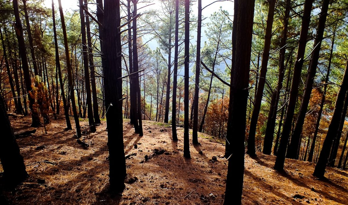
— June 2013. A good number of slopes bordering this trail burnt during the summer of 2012. Some of the slopes were completely torched while others only had the underbrush catching fire. Earlier this year, deadfall across the trail made it difficult to ride, but all that deadfall has been cleared now. Expect windstorms and snowstorms to drop plenty of new deadfall across the trail in years to come.

Photos: The fires of 2012 fried this particular stand of trees. In stands like the picture above, wind and snowstorms will drop trees across the trail every winter. Elsewhere (see second picture above), fire simply cleared out the fuels accumulating in the under story and left the trees in excellent shape.
Leave It Better Than You Found It: This should be every outdoor user’s goal. Pick up trash left by others, pull noxious weeds along your route, disperse old fire rings (they encourage more fires), throw branches over spur trails and spurs between switchbacks (make it harder to do the wrong thing than the right thing).
Important Disclaimer: Treat this information as recommendations, not gospel. Things change, conditions change, and those contributing these reports are volunteers–they may make mistakes, fail to give complete information, or may not know all the issues affecting a route. So forget about finger pointing: If things go wrong, you are completely responsible for yourself and your actions. If you can’t live with that, you are prohibited from using our information.


