
Photo: Views of Leavenworth from Mountain Home Ridge, owned by the Land Trust
Mountain Home Ridge is a 169-acre property purchased by the Trust for Public Lands (TPL) in 2008 and then donated to the Chelan-Douglas Land Trust. The property is a linkage between Forest Service lands to the north and to the south, and preventing future development here will help maintain connected corridors of wildlife habitat on this ridge system flanking Leavenworth to the south.
Some of the Mountain Home Ridge acreage is forested and there is a small wetland near the southern boundary, but a considerable portion of the acreage here was badly torched in 1994 by the catastrophic Rat Creek Fire. Interestingly, these burnt lands, while not the prettiest, are very important wildlife. The open canopy of the burns supports an understory of broad-leaf shrubs and forbs that support many animals (deer and bear) while the dead snags support insects and, therefore, animals feeding on insects like birds.
The burns may not be the most pleasing to the human eye, but they also open up views over the lowlands of Icicle Creek and the highlands of the Cascades, and these are incontestably gorgeous.

Photo: Neal Hedges, the Stewardship Director for the Land Trust, monitoring the property.
A few dirt roads (in various stages of being reclaimed by vegetation) dissect the property are available to the public for non-motorized use. This allows hikers, mountain bikers, equestrians, and birders to enjoy the area’s views, bird life, and plant life. Visitors can take several different short walks on the property. Or they can undertake a few longer loops using Mountain Home Road, the Boundary Butte Road, or the Ridge Ride Trail that will have them passing through the property.
Uses: Hiking, mountain biking, horseback riding, birding. Motorized recreation is prohibited on the property.
Skill: 2- (low intermediate and above) Fitness: 2- (low intermediate and above)
Distance. Various trips on or through the property allow for out-and-back trips or loops ranging from 3 to 8 miles in length.
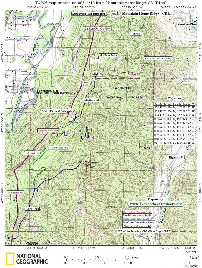
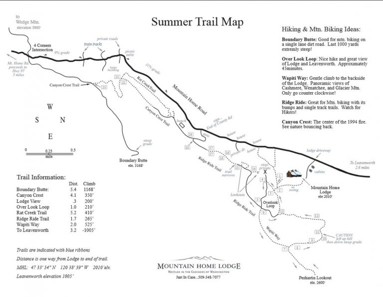
Maps. See our topo map below. Also view our schematic map of the trails produced by Mountain Home Lodge.
GPS Info. Download the GPX file with the waypoints noted on our map.
Access. From the east end of Leavenworth, turn south off Highway 2 onto East Leavenworth Road. In about 70 yards, turn left on Mountain Home Road and follow it uphill. A total of 3.5 miles from Highway 2, park in a fairly large pullout on your right. On left side Mountain Home Road there’s a dirt road that is gated after about 50 yards. This road is the start of the riding/walking options listed below.
Instructions:
-
Mile 0.0 (waypoint 1 on map). Start walking/riding from the pullout. Head up the dirt road on the opposite side of Mountain Home Road and around the gate.
-
Mile 0.27 (waypoint 2). Junction in the road—stay right. Note: Going left here takes you off Land Trust property in short order and onto the Ridge Ride Trail, which follows an undulating ridge crest. After 0.9 mile reach a sign (waypoint 11) pointing straight ahead for the Lodge Lookout. If you stay on the main road, which hooks right, you can ride east and then north for another 1.1 miles to a viewpoint some call the Peshastin Lookout (2,665’).
-
Mile 0.33 (waypoint 3). Another fork in the road – stay right. Note: Going left here has you climbing gradually uphill for 0.6 miles to a good viewpoint and the end of the main road. You can walk/ride uphill from the end of the road along a ridge crest heading toward Boundary Butte for another 0.15 miles before the travel turns into a bushwhack.
-
Mile 0.66 (waypoint 5). You’ll reach waypoint 5 on the map after a steeper section of road and a right-bending curve. In the future, the Land Trust plans to build a trail to the right of the road along the ridge system leading to a viewpoint (waypoint 6). This ridge can be walked now but you will need to contend with some brush and deadfall. Once you reach waypoint 6, keep following the faint trail along the ridge crest (Rat Creek Trail) to waypoint 7. Alternately, follow the main road in a southwesterly direction to waypoint 7.
-
Mile 1.47 (waypoint 7). Reach a T-intersection and go left on the Canyon Crest Trail. Note: Going right takes you on the Rat Creek Trail to waypoint 6.
-
Mile 2.25 (waypoint 8). Reach another T-intersection with a Forest Service Road (Rd 7300-500). Turning left gets you to the top of Boundary Butte after 1.1 miles. Turning right takes you down to the Mountain Home Road in 1 mile. Once you intersect Mountain Home Road a right turn will return you to the car after another 2.5 miles.

Photo: A ridge with a view (taken near waypoints 9). See map.
Permits. None needed.
Leave It Better than You Found It. This should be every user’s goal. Pick up trash left by others, pull noxious weeds along your route, throw branches over unwanted spur trails, etc.
Disclaimer. Treat this information as recommendations, not gospel. Conditions change and those contributing these reports are volunteers–they may make mistakes or not know all the issues affecting a route. You are responsible for yourself, your actions, and your safety. If you won’t accept that responsibility, you are prohibited from using our information.