Attractions: This ride has a physically tough ascent and really fun descent along a long ridge. It is a technically interesting ride. The ride uses some gravel fire roads, but most of the descent is single-track trail.
Skill: 4 (expert) Overall the ride is more of 3 but has a few exposed tricky areas
Fitness: 3 (advanced)
Distance: 28-mile loop
Elevation Gain: 1,900 to 6,900
Around 5,000-foot gain plus some additional undulating terrain.
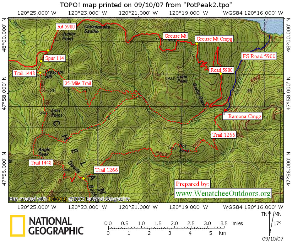
Maps. See map below for more information.
Access: From the Wenatchee Valley, drive Highway 97A toward Chelan. Take the left onto Highway 971 (Navarre Coulee Road)and drive about 30 miles to the T in the road at Lake Chelan. Go left on South Lakeshore Drive and drive to Twenty-Five Mile Creek State Park. On the other side of the state park, turn left onto the road leading to Shady Pass (FS Road 5900). Drive uphill about 2.6 miles and then at the “Y” go left and in a half mile park at the Ramona/Snowberry Bowl Campground (el 1,900 feet).
Trip Details:
- Start by riding the access roads a half mile back to the “Y” described in the access information. At this Y, turn left onto FS Road 5900 and ride about 5.5 miles uphill to Grouse Mtn Campground.
- Remain on FS Road 5900 for another 6.75 miles past Grouse Mtn Campground. Then, at a saddle, turn left onto Spur 114 leading toward Handy Springs Campground and which gives access to Trail 1448 in about .35 miles.
- Follow Trail 1448, which leads to the Devils Backbone and which undulates up and over a number of peaks like East Peak and Angle Peaks. This is exciting and technical ridge riding with some dramatic (i.e., scary) exposure as well as about .75 miles of hike-a-bike up talus slopes. Some 6 miles along Trail 1448 on a 6,690-foot knoll, you’ll intersect Trail 1266.
- Turn left onto Trail 1266 and start a nine- to ten-mile descent that many riders consider to be the best descent in the state (yup, even better than such classics as Devils Gulch, Taneum Creek, and Twenty-Five Mile Creek).
- The descent ends back at Ramona Campground where you started.
Making It Easier: You need to be a fit rider to do the route as described. Technically competent but less conditioned riders can make the ride easier by dropping a shuttle car at the Ramona Campground and then driving Road 5900 up to the Grouse Mountain area to actually start riding.
Best Season: Early summer to late fall. The ride is dry and can be hot, so bring lots of water.
Permits: Northwest Forest Pass required at the trailhead.
Additional Information: See dirtworld.com for more info.
Additional information about this ride can be found in John Zilly’s book “Mountain Bike–Northwest Washington”
Comments:
–Richard Uhlhorns, a Chelan resident and photographer says,
“Slamming, technical 10-mile downhill ride to the Ramona Park Trailhead. The ride is well worth the effort. Bring food and water with you.”
–Trail had been closed in early 2005 due to the 2003 fires but reopened in late July of 2005. This is singletrack riding at its finest. Tough climb but smooth, undulating ridge top descent.
Leave It Better than You Found It. This should be every user’s goal. Pick up trash left by others, pull noxious weeds along your route, throw branches over unwanted spur trails, etc.
Disclaimer. Treat this information as recommendations, not gospel. Conditions change and those contributing these reports are volunteers–they may make mistakes or not know all the issues affecting a route. You are responsible for yourself, your actions, and your safety. If you won’t accept that responsibility, you are prohibited from using our information.