
By Matthew Tangeman
Attractions. In an area crowded with motors — where the smell of exhaust often intermingles with that of pine and where 700cc engines churn trails to dust — finding a quiet and maintained mountain bike ride is a special treat. Fortunately, this loop on the flanks of Table Mountain, provides just that, topped off with gorgeous views, technical riding, and, if you’re lucky, exceptional wildlife watching. The area is home to one of the largest elk herds in the state, and while they tend to make themselves scarce later in the day, a dawn patrol start will increase the odds of sightings.
Activity: mountain biking, trail running, hiking.
Skill: 3 (advanced)
Fitness: 2 (intermediate)
Distance: 6 miles (loop)
Elevation: 1300 feet
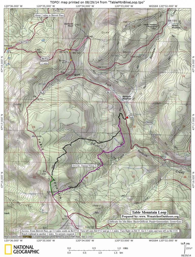
Map. See our topo map below for more information.
Access. Follow Highway 97 south to Blewett Pass (elevation 4100’). Just beyond the highpoint of the pass, turn left (south) on Forest Road 9716. Drive 3.6 miles, then turn left onto Road 9712 and go 1.5 miles to a pass. Turn right onto Road 35 and, in 0.1 miles, turn left at a Y onto Road 3530. Avoiding spurs, continue about 2 miles before reaching a small pullout and a sign for the Naneum Meadows Trail 1389.
Trip Instructions.
* Start on Naneum Meadows Trail 1389, on the right (west) side of the road next to the sign. For 0.7 miles, push through a steep and loose climb.
* At 0.7 miles, reach a junction. The Naneum Meadows Trail goes right, and the Naneum-Wilson/Owl Creek Trail goes left. While the loop can be done in either direction, the Naneum-Wilson Trail is a little more gradual with fewer hike-a-bike sections, and makes for a generally better ascent.
* Assuming the Naneum-Wilson Trail is your uphill track of choice, follow this narrow side hilling trail up and the across a plateau with views to Mount Lillian and Table Mountain.
* Next, the trail crosses forks of Owl Creek on some nice bridges (courtesy of the Backcountry Horseman’s Association), and briefly joins a fire road. After about 100 yards on the fire road, turn right on a trail marked 1371.2 (across from the Forest Service “Route” sign).
* Now on the Owl Creek Trail, get ready to gear down and fire those calves as the trail steepens and becomes riddled with loose talus in the burn area. All but the strongest pedalers will be hiking at least a couple sections. The trail crosses a road at one point but stay on the single track.
* Cruise through a grassy meadow and finish a final climb to FR 35. Cross the road and hike around to take your pick of any number of grassy knolls with spectacular views over the Ellensburg Valley, in the shadow of Mt. Rainier.
* Back on the bike, pedal right (north) up FR 35 for a gravely 0.4 miles. Just after reaching a highpoint, look for a big sign marking the Naneum Meadow Trail on your right. This is your descent. Drop in.
 * Advanced riders will be all smiles on this rocky and rooty trail. Less experienced mountain bikers will certainly have their share of grins as well but may be more comfortable walking down a few steep, loose sections. Be sure to slow down occasionally look for elk in the small, marshy meadows off the trail. After a 2.3-mile downhill, connect with the Naneum-Wilson Trail and head left for a fast 0.7 miles back to the starting point.
Other Issues. The area is also hugely popular with hunters — if you visit in the fall, wear bright clothing and leave the antlers at home.
Allowed. Mountain bikers, horses, dogs, hikers, and motorcycles.
Fees/Permits. As of August 2014, no permits were needed for this ride.
Date: First posted August 29, 2014.
Leave It Better Than You Found It: This should be every outdoor user’s goal. Pick up trash left by others, pull some noxious weeds along your route, throw branches over unwanted spur trails, don’t ride or walk wet trails when you’re leaving ruts/footprints deeper than ¼ inch…
Disclaimer. Treat this information as recommendations, not gospel. Conditions change and those contributing these reports are volunteers–they may make mistakes or not know all the issues affecting a route. You are responsible for yourself, your actions, and your safety. If you won’t accept that responsibility, you are prohibited from using our information.