While this 13-mile loop on gravel roads offers nothing truly spectacular, this is still a pleasant ride, with a dose of steep climbing at the beginning, a segment of ridge-riding in the middle, and some pleasant downhills at the end. Technically, the ride is easy enough for beginners to bank some mileage and bike handling skills. Physically, the ride is tough enough to purge the body of some unneeded fat cells … a process we may grumble about while it’s happening and be glad about afterward.
Access. Drive from Leavenworth to Plain on highway 209. Drive through Plain and continue another 1.8 miles. Take the turnoff to the left, Forest Service Road 6601. It is not signed at the highway. Turn onto this road and park. Starting elevation: 2,000 feet.
Distance: 13-mile loop. Elevation Gain: 1,300 feet
Difficulty. The most significant climbing is in the first 2.3 miles of this ride. After that, it continues at a moderate and then a gentle incline until reaching Natapoc Ridge at mile 5.5.
Trip Instructions:
- 0.0 miles: Intersection of highway 209 and Forest Service Road 6601.
- 1.3 miles: Pass Spur Road 110 on your left. You will return on this road. You are starting the steepest part of the climb.
- 1.7 miles: Pass Spur Road 150 on the right. Keep climbing.
- 2.3 miles: Pass Spur Road 210. The pitch now lessens.
- 4.6 miles: Pass Spur Roads 510 and 450. You are at the top of Natapoc Ridge (3,120 feet).
- 5.5 miles: You’ve reached the peak of the climbing at 3,300 feet. Get ready for some downhill cruising.
- 8.8 miles: Spur Road 110 on your left. Take this. It is a dirt road with gentle ups and downs.
- 11.6 miles: Spur Road 110 joins with Forest Service Road 6601. Déjà vu!–you’ve been here before! Go right.
- 13.0 miles: Back at the car.
Season. Best in fall and spring. It can be pretty hot in mid summer.
Hazards. Think about wearing bright clothing during hunting season. If you decide to bring your dog along on this one, make sure to watch for potential vehicles.
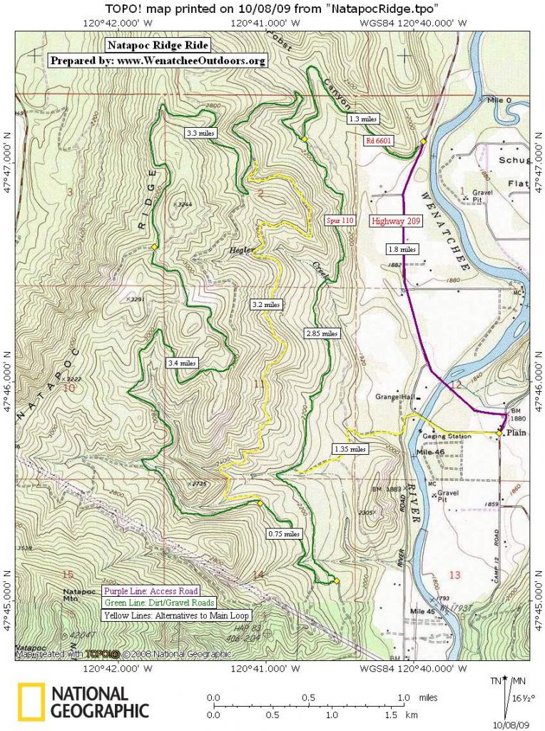
Maps. See our topo map below for a detailed look at the ride, and theWenatchee National Forest map for a general look at all the forest roads in the area.
Trip Reporter: Carolyn Griffin-Bugert, October 2009.
Leave It Better Than You found It. This should be every user’s goal. Pick up trash left by others, pull noxious weeds along your route, throw branches over unwanted spur trails…
Disclaimer. Treat this information as recommendations, not gospel. Conditions change and those contributing these reports are volunteers–they may make mistakes or might not know all the issues affecting a route. You are responsible for yourself, your actions, and your safety. If you won’t accept that responsibility, you are prohibited from using our information.