Tumwater Mountain (Mountain Bike Ride)
Attractions: The climb up Tumwater Mountain (above Leavenworth) on Forest Road 7701 is a steady grind that gets the heart hammering. The road is well graded but it’s also relentless, gaining 2,700 feet over the course of five miles. While the ride is not technically challenging (Freund Canyon is a more interesting technically) this ride gets you much higher than Freund–it works your heart over but gives your eyes more to feast upon. In recent years, the top of Tumwater Mountain has been developed as a launch site for local paragliders and, with a little luck, you may get to enjoy some aerial antics up top before starting your own flight down. On the descent you can retrace the up route or traverse over to Freund Canyon or, half way down, traverse over to Freund Canyon and throw some more technical single-track riding into the mix.
Activity. This entry is written as a mountain bike ride but hikers and trail runners will also enjoy this route. Dirt roads are never quite as nice for hiking as trails but a hiker who has done most of the other local trails will eventually want to explore Tumwater Mountain.
Distance: Two main options are listed– both are about 11.5 miles long (roundtrip)
Elevation: Leavenworth: 1,175 feet. Ridge: 3,875 feet. Gain: 2,700 feet.
Skill: 2 (intermediate)
Fitness: 2+ (hard intermediate) to 3- (easy advanced)
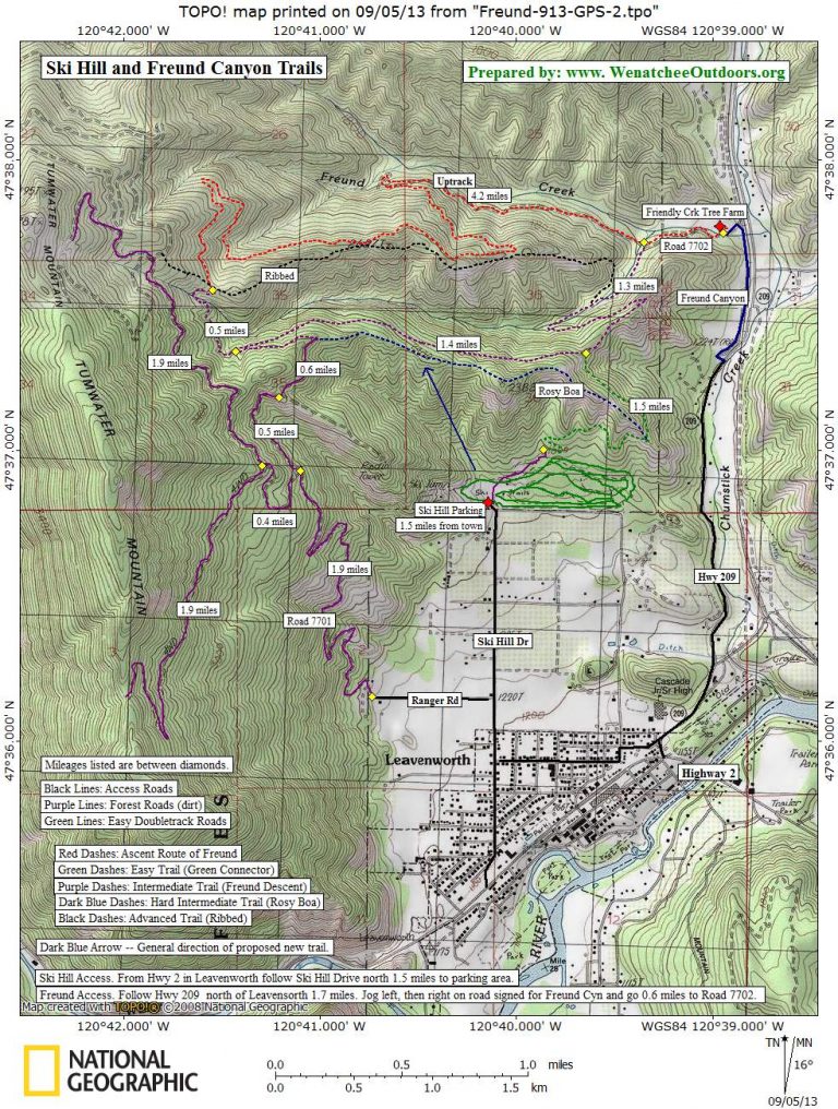
Maps. See map below for more information.
Access: One of the beauties of this ride is you can access it easily from anywhere in town. Leave the car anywhere you like in Leavenworth proper. The ride description starts at the intersection of Ski Hill Road and Highway 2.
Trip Description:
Ascent
- Head 0.75 miles up (north) on Ski Hill drive to Ranger Road and turn left.
- Go west on Ranger Road for 0.45 mile where it hooks right, turns to gravel, and starts to climb in earnest.
- Just after the road turns to gravel you’ll pass some private driveways but follow the sign directing you to Tumwater Mountain and get ready to climb.
- After 2.1 switch backing miles, reach a major road junction (el 2,620). The right branch contours for 1.2 miles until it reaches a single-track descent down Freund Canyon. Taking this road into Freund Canyon is a good option for the return trip. For now, however, stay left and keep climbing steadily.
- In another 0.4 miles, reach another major road junction (2,900 feet). Two options exist here:
- 1) Go left and keep climbing for 2 more miles to road’s end and a saddle at 3,875 feet. The ridge accessed by this road is scenic and it’s worth taking a short hike to your left (south) to enjoy the setting and the views over Leavenworth. Some climbers drive up here to boulder along this rocky ridge.
- 2) Go right and, in 1.2 miles, reach another major Y in the road (el 3,370). If you go right for 100 yards, you can ride the steep single-track spur of Ribbed (best for downhill riders) that drops you into Freund Canyon. For now, go left on Spur 500 and remain on the most-travel road, passing a spur on your left in about 100 yards. Keep climbing. In another 0.3 miles, reach a 5-way intersection — go left on the spur that climbs the steepest. Now another 0.5 miles of climbing delivers you to the end of the road. Leave the bike and scramble a few hundred vertical feet to the ridge.
Descent
Option 1: Retrace your up route.
Option 2: Head downhill and use one of the two access points into Freund Canyon described earlier. Descend Freund Canyon on single-track trails. Use Highway 209 to return to Leavenworth. See our Freund Canyon guidebook entry for details about these trails and the return to Leavenworth.
Land Ownership: County and Forest Service Roads.
Permits: None required.
Trip Report: Prepared 9/15/2007. Updated September 2013 and June 2015.
Leave It Better than You Found It. This should be every user’s goal. Pick up trash left by others, pull noxious weeds along your route, throw branches over unwanted spur trails, etc.
Disclaimer. Treat this information as recommendations, not gospel. Conditions change and those contributing these reports are volunteers–they may make mistakes or not know all the issues affecting a route. You are responsible for yourself, your actions, and your safety. If you won’t accept that responsibility, you are prohibited from using our information.