Enchantment Lakes Traverse
by Andy Dappen
If a book titled The 100 Best Hikes in North America were to be written, the Enchantment Lakes Traverse would be the choice put forth to represent Central Washington. The hike is physically challenging (20 miles long with 4,500 feet of elevation gain), biologically diverse (spanning everything from muscular old-growth forests to dwarf alpine vegetation), and scenically resplendent (with sparkling lakes and tumbling streams in the foreground, and black spires and white volcanoes in the background).
Unfortunately, getting a permit for a multi-day hike in the Enchantments is almost as hard as getting the body up and over the route. Because the area is so spectacular with its rock-rimmed lakes, sharp granite p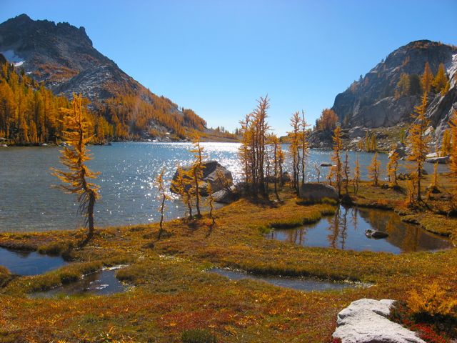 eaks, water-smoothed slabs, and gnarled larch trees, everyone wants to complete this trip. To keep the crowds manageable and to keep the area from being loved to death, the Forest Service has instigated a lottery system for camping permits.
Frankly, applying for and winning such a permit is a major pain in the Aasgard, and the way around the lottery-game hassles is to do the traverse a day trip. While this avoids the need for camping permits, it does require that the body be in shape for a burly day that will have you walking 20 miles and climbing 4,500 feet of elevation.
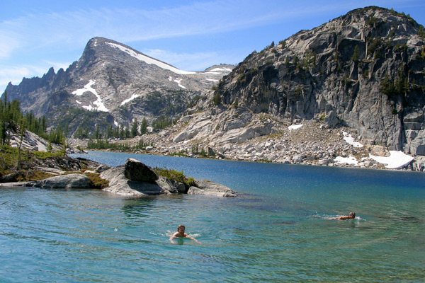
It’s an endeavor many will need to work up to, but it is worth the preparation. Whether you do this route on a hot summer day when you swim frequently in the cellophane-clear lakes passed along the way, or you walk through in early October when the larch trees are on fire with color, this is special hike… one our region can offer up proudly against the best anywhere.

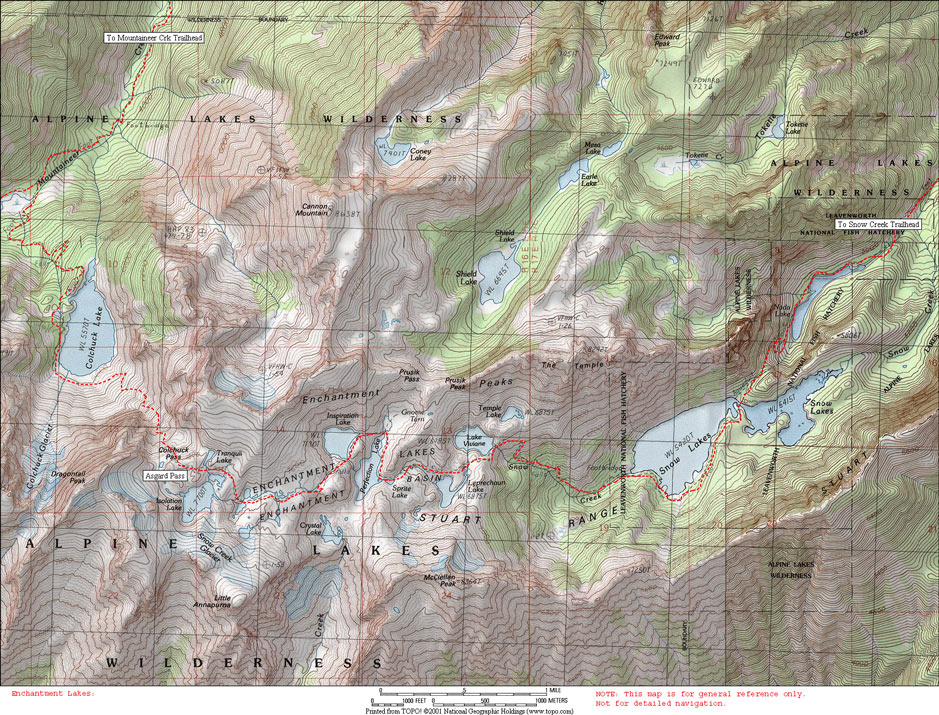
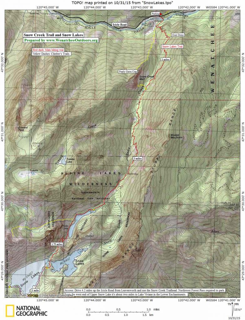
Maps: Map 1 covers most of the traverse while the end of traverse (Snow Lakes to the trailhead) is covered by Map 2. Note: use ‘Print Preview’ to properly scale these maps to your printer and a full sheet of paper.
Activity: Hiking, trail running, outdoor photography
Nearest Town: Leavenworth
Skill Level: 3 (advanced)
Fitness Level: 3+ (strong advanced)
Access. From the west end of Leavenworth take the Icicle River Road up to Bridge Creek Campground (about 8 miles), cross the bridge across Icicle Creek here, and follow the Eightmile Road 4 miles up to its end at the Mountaineer Creek Trailhead (same access point used for the Colchuck Lake and Lake Stuart hikes). A Northwest Forest Pass is needed to park here.
Shuttle. Most groups will want to leave a shuttle vehicle at the Snow Creek Trailhead (4.2 miles from Leavenworth along Icicle River Road) as they drive up to Mountaineer Creek. Really burly groups (or really energy-conscious ones) will leave a mountain bike at the Snow Creek Trailhead to retrieve the car at the end of the day. A Northwest Forest Pass is needed for cars left here as well.
Trip Instructions:
* Follow the trail to Colchuck Lake as described in this post.
* Once at Colchuck Lake, follow a much rougher and less distinct trail, counter clockwise around the lake. This is considerably harder walking and, on the south end of the lake, you’ll do a lot of boulder hopping.
* At the southeast edge of the lake, work up the switchbacking trail leading to Aasgard Pass. It’s a long, steep climb gaining about 2,400 feet of elevation.
* From Aasgard Pass, the trail meanders past the southern end of Tranquil Lake; over to the southern end of Inspiration Lake; past the northern ends of Perfection Lake, Sprite Lake and Leprechaun Lake; and past the southern end of Viviane Lake.
* Beyond Viviane Lake the trail drops down to Snow Lakes, roughly paralleling Snow Creek most of the way down and remaining on the slopes north of the creek until you’re quite close to Upper Snow Lake. This cairned trail can be tricky footing and indistinct in places. Take it slow and pay attention.
* At Upper Snow Lake walk 1.5 miles counterclockwise around the southern portion of the lake and then cross the dam/spillway separating the upper and lower lakes.
* Now you’ve got a 1.7 miles of walking on a major trail to reach Nada Lake.
* Finally you’ve got another 5.6 miles of walking along Nada Lake and then along Snow Creek to reach your shuttle vehicle at the Snow Creek Trailhead.
Note. This is a beautiful trip in early October when the larch trees are yellow and the air is crisp.
Fees/Permits. Permit season for overnight trips to the Enchantments is mid-June until mid-October. Click here for details or call the Leavenworth Ranger Office (509-548-6977) to learn how to compete for a permit and/or how to get a permit the day of your trip. A Northwest Forest Pass is also needed to park at the trailheads. If you’re just taking a day trip into Colchuck, you don’t need to play the lottery game for a camping permit, but you still need to carry a self-issued wilderness permit picked up at the kiosk at the very start of the trail (free).
More Info/Links: For more information about hiking in the Enchantments, click here.
Dogs and Horses are prohibited in the Enchantments and on all the trails mentioned as part of this traverse.
Also Not Allowed. Campfires are prohibited in the Enchantments and at Colchuck Lake. All forms of motorized travel are prohibited on these trails as well.
Recent Conditions and Reports. The condition reports tacked to the bottom of this link on the Washington Trails Association’s website are among the most current available. The Forest Service lists current conditions here.
Dates. This report was first prepared in August 2007. We did a major re-write, updated links, and added new reference materials on 6/24/2015.
Leave It Better Than You Found It. This should be every outdoor user’s goal. Pick up trash left by others, pull some noxious weeds along your route, throw branches over unwanted spur trails, don’t ride or walk wet trails when you’re leaving ruts/footprints deeper than ¼ inch…
Disclaimer. Treat this information as recommendations, not gospel. Conditions change, and those contributing these reports are volunteers–they may make mistakes or may not know all the issues affecting a route.You are still completely responsible for your decisions, your actions, and your safety. If you can’t live with that, you are prohibited from using our information.
This guidebook post is sponsored by Northern Fruit Company. Northern fruit has been a steadfast supporter of WenOut since its inception in 2005. Northern Fruit appreciates and supports organizations that foster the physical well being of our community members along with a collective voice for our outdoor recreation community.