“Why is kayaking so much fun?”
Initially Paul Milem’s question as we drive up the Entiat River Road toward the put-in for the Lower Entiat River seems like an awkward attempt to fill the silence in the car. Then the question seems silly. But when I realize Paul is asking a serious question, it’s hard to provide a simple answer.
Paul is fairly religious and thinks the kinesthetic enjoyment (love of motion), aesthetic appreciation (joy of beauty), athletic pleasure (mastery of skills), chemical pleasure (adrenaline rush), social enjoyment (camaraderie among friends), physical pleasure (runner’s high from exertion) are a result of God having designed us this way. Furthermore he thinks when we’re having fun, “God is having fun too.”
I’m less of the belief that God consciously wired me this way and more inclined to believe that those of us who enjoy motion, physical exertion, adrenaline sports, and exploration come from a line of risk-takers and explorers who managed to propagate their genes. Meanwhile, people with Asian philosophic roots might maintain that kayakers are the re-incarnated spirits of water spiders or river otters.
We examine the question briefly before I wonder aloud about the opposite pole of Paul’s question. “Kayaking is fun to some of us, but there’s a larger group of people who wouldn’t enjoy whitewater paddling.”
“Why kayaking isn’t fun is a different question. It’s hard to understand how something so fun for me isn’t at all fun to others,” Paul says.
“Tipping over, banging your head on rocks, swimming in ice-cold water, drowning upside-down in a coffin shaped tube…what part of these possibilities is hard to understand?”
“Which leads back to my question: Why is kayaking so fun?”
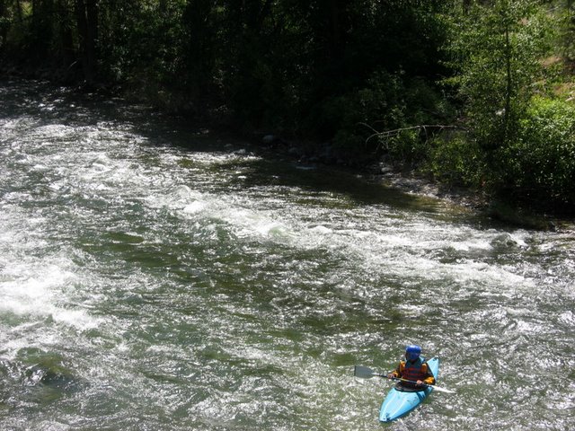
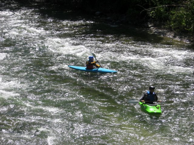
The next several hours as we kayak the ten river miles of the Lower Entiat River between where the Mad River enters the Entiat (near Ardenvoir) and where the Entiat enters the Columbia, I keep returning to the conversation. The river is a fast-paced, nearly continual string of class 1 and class 2 rapids–for kayakers with moderate skills this provides action without terror.
Along the way many waves and small holes present good surfing opportunities for intermediate boaters—these surf spots are large enough to grab your attention yet are not so large as to munch you. The river is narrow, lined with the dead limbs of cottonwoods and the live branches of red ozier dogwoods so the traps lining the shores require vigilance without creating heart-in-mouth anxiety.
Meanwhile the red-barked glades of ponderosas rising steeply above us contrast with the choke of riparian vegetation at water level. Naturally, there’s also the pleasure of feeling the East Slope sunshine warming our winterwhite bodies—especially on a day like today when Western Washington is blanketed in clouds. And there’s the fun of having crept away from work two hours early on this Wednesday afternoon and knowing that, while we enjoy this backyard amusement ride, the rest of the working world is holed up in little cubicles.
After a few hours of exercise, play, scenery, sun, and excitement, we’re at the take-out strapping Tupperware boats to Yakima racks. “I still can’t tell you ‘why’ this is fun,” I tell Paul, “But let’s do it again next week.”
Details, Details
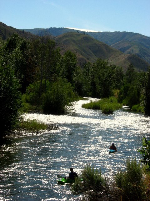 While the rapids are not as large as on some rivers, the Entiat provides plenty of action with constant Class II rapids and the occasional Class III drop. The riverside scenery includes many small farms and orchards and the vegetation shifts from forest to desert as you near the Columbia. The Entiat flows along the base of a narrow valley and offers a pleasant paddle without the crowds of other rivers emptying into the Columbia.
Activity: Whitewater paddling
Nearest Town: Ardenvoir, Entiat
Skill Level: 2+
Fitness Level: 2
Distance: 10 river miles
Elevation: 1345 ft to 720 ft; 51 feet per mile
Recommended Season: May to mid-July
Difficulty. Fairly continuous Class 1 action with a few class 2 rapids and perhaps one 2+ rapid. Difficulty is, of course, dependent on the water level. The river doesn’t have that many natural eddies but you will find quite a number of small surf waves and small holes to play in.
Access. Drive Highway 97A to the south side of Entiat. Turn east onto the Entiat River Road and head upstream. In roughly half a mile, pass a small natural area on your left with interpretive signage and a road paralleling the main road. This is the take-out (leave an extra vehicle or bicycle here). Drive about 9 more miles upriver and take a left on the Mad River Road. This road immediately crosses the Entiat River and, in another 100 yards, you’ll find a park that is part of the Two Rivers Ranch development project on your left. Park and unload the boats. Carry boats 100 yards back to the bridge, walk down the right-side bank of the road, and put-in at a small calm spot where the Mad River and Entiat River merge.
Trip Instructions:
- We found the river quite scoutable as we floated but the river is swift and is a nearly continual progression of Class 1 and Class 2 waves. There are some large holes where the river spills over boulders that require attention.
- As of mid June, 2008 there were not any sweepers blocking the river. However, river conditions change quickly. There are quite a number of leaning trees that more erosion and/or windstorms will eventually knock into the river. Because the river is narrow, you should always consider new sweepers and strainers to be a possible hazard.
- Powerline Rapids (Class 2+ or 3) appears just below a low cable crossing the river and above the bridge at RM 8.
- An old weir spans the river roughly 3 miles downstream of the put in (about RM 7.5) This creates a small, recirculating wave that we found easy to punch with a little speed.
- About 3.5 miles downstream of the put-in (about RM 7) there is a hazardous fish trap blocking the main river flow as you go under the Roaring Creek Road bridge. We passed the fish trap on river right (river left had a hazardous cable attached to the trap). This trap is worth scouting while driving to the put-in (turn left on Roaring Creek Road and check the fish trap from the bridge). Signs upstream of the trap also notify paddlers that there is a hazardous obstruction in the river.
- We encountered one other fish trap anchored to the left side of the river about 2 miles farther downstream from the trap mentioned above. This was easily passed on river right. Signs upstream of the trap gave paddlers warning of this hazard.
Hazards. Be on the watch for the weirs, fish traps, and strainers on the river. High water levels can make it difficult to find an eddy on this river.
Water Level:
–Recommended level: As a general rule the flow on the Entiat is usually best when the Peshastin Gauge on the Wenatchee River reads between 5,500 and 11,000 cfs. The river is rocky below 5,500 cfs, and over 11,000 cfs washes out many of the rapids and makes it difficult to find eddies.
–Recommended levels taken from the Ardenvoir Gauge on the Entiat are between 900 cfs and 1500 cfs.
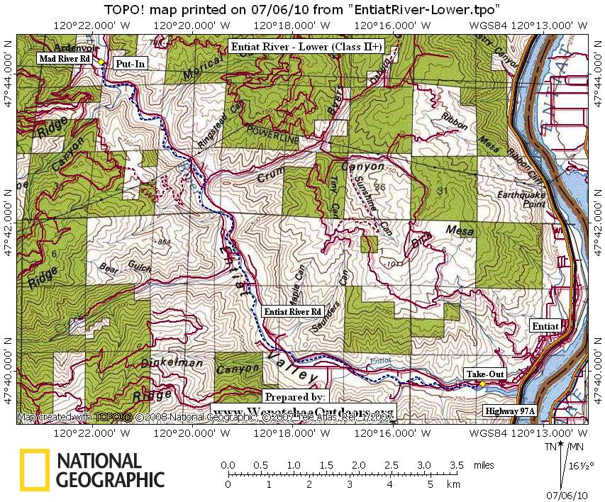
Map. See map below for more information.
Land Designation. Private and Forest Service.
More Info/Links. See the American Whitewater website and Washington Whitewater II, written by Douglass A. North and published by The Mountaineers. River conditions are subject to change, especially after storms or floods. For more the most up-to-date information or to view photos and user comments, check this river’s information at American Whitewater. For American Whitewater’s listing of all Washington rivers and their current water level, click here.
Trip Reporter: Andy Dappen, 6/25/08. The river flow for this report was at 1,100 at the Ardenvoir gauge.
Leave It Better Than You Found It: This should be every outdoor user’s goal. Pick up trash left by others, pull some noxious weeds along your route, throw branches over unwanted spur trails, don’t ride or walk wet trails when you’re leaving ruts/footprints deeper than ¼ inch…
Disclaimer. Treat this information as recommendations, not gospel. Conditions change and those contributing these reports are volunteers–they may make mistakes or not know all the issues affecting a route. You are responsible for yourself, your actions, and your safety. If you won’t accept that responsibility, you are prohibited from using our information.