
Upper Nason Creek from Berne to Merritt:
Distance: 8 miles
Difficulty: Class IV-V
Skill: 4 (expert)
Fitness: 3 (advanced)
Average Gradient: 84 fpm
Gauge Information. There is a Department of Ecology gauge on Nason Creek. The USGS gauge Wenatchee at Peshastin is also used to gauge flows (also available through the NOAA hotline 206-526-8530). Although it can be run higher, look for flows of approximately 6000-8000 cfs on the Wenatchee gauge for a first trip. The actual flow will be approximately 5-10% of the flow on the Wenatchee.
Put-In and Take-Out. The put-in is at a pullout at milepost 71 along Highway 2 some seven miles east of Steven’s Pass. A short ways east of the put-in you’ll be able to see the creek and The Slides along the north side of Highway 2. Take-out at mile 78.7 where the creek comes along Highway 2. Or, if you want to avoid a few miles of class II at the end of this run, find an appropriate pullout along the Whitepine Road, which roughly parallels Nason Creek for three miles between Highway 2 and the Whitepine Campground. The Whitepine Road splits off of Highway 2 at about milepost 78.4.
Trip Description:
-
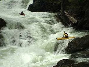
The river starts out with The Slides which is a set of class IV ledges. You can scout these drops before the run from Highway 2. If they make you nervous then you’re best off heading someplace else, but if they look like fun you should be good to go.
-
After the Slides, the creek passes through the railroad tunnel and then under Highway 2. It mellows for quite a bit before you hit a couple ledges.
-
When you see the railroad grade on the right, get out for a scout. This is the start of the canyon which you can check out from the rim. You can walk the entire rim down to the railroad bridge (be sure to check the last ledge below the railroad bridge which has a bad spot on the left). Keep in mind the ledges are stickier than they look from above. Trivial Pursuit and Royal Flush are a class V combination.
-
After you pass under the railroad bridge there are more fun ledges until you reach the confluence with Whitepine Creek where things start to mellow, eventually slowing down to class II.
The source of the information included in this entry is the American Whitewater website. River conditions are subject to change, especially after storms or floods. For more the most up-to-date and detailed information or to view photos and user comments, check this river’s information at American Whitewater.
Hazards: Besides the usual suspects related to water running down a steep ravine (boulders, holes, pourovers, ledges), woody matter may can be in or across the creek on any given year. Try to get updated, local beta before heading out.
Condition Updates: When the run is ‘in’ Leavenworth Mountain Sports (509-548-7864) usually knows whether there are blockages in the river.
Got Updates? If you have corrections or a better account of running this section of river, please submit it to the editor at WenatcheeOutdoors.org so we can improve our information.
Leave It Better Than You Found It: This should be every outdoor user’s goal. Pick up trash left by others, pull some noxious weeds along your route, throw branches over unwanted spur trails, don’t ride or walk wet trails when you’re leaving ruts/footprints deeper than ¼ inch…
Disclaimer. Treat this information as recommendations, not gospel. Conditions change and those contributing these reports are volunteers–they may make mistakes or not know all the issues affecting a route. You are responsible for yourself, your actions, and your safety. If you won’t accept that responsibility, you are prohibited from using our information.
