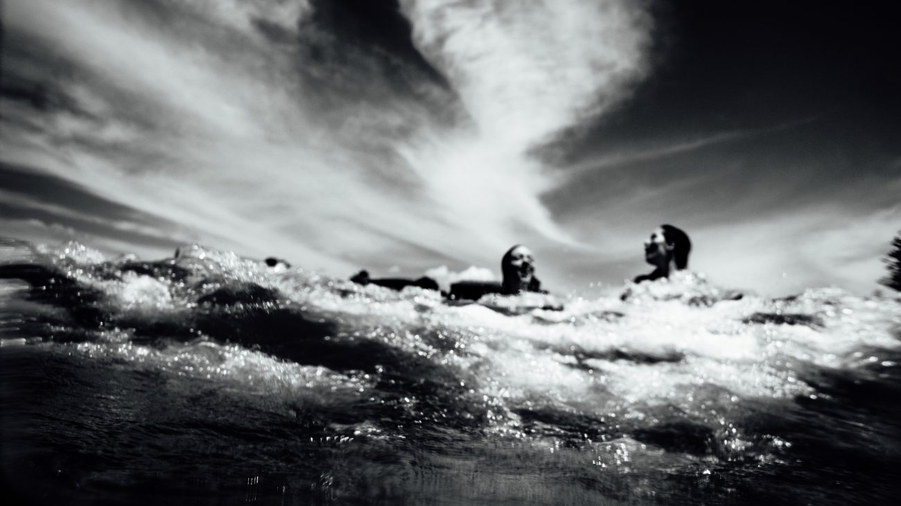

John Marshall Photo: Alex Carlson surfing on the Wenatchee River.
Attractions: The Wenatchee River between Peshastin and Cashmere is one of the most popular whitewater runs in the state. Why? Lots of sunshine during the spring melt-off (unlike West Side rivers), warmer temperatures, quick shuttling, easy access to and exit from the river, loads of Class 2 and 3 rapids to keep things entertaining, pools after most drops to pick up any wreckage, and scenic views of the Wenatchee Valley orchards. Besides offering river runners loads of good fun, the Wenatchee offers playboaters excellent access to fun surfing holes and waves. This particular trip description describes the 9.25 miles of the Wenatchee River between the river towns of Peshastin and Cashmere.
Skill: 2+ or intermediate (Class II to III+ rapids)
Fitness: 2 (intermediate)
River Levels and Gauges:
Suggested minimum level: 2,500 cfs.
Recommended maximum 20,000 cfs.
Refer to the USGS gauge at Peshastin or call the NOAA hotline for gauge information: 206-526-8530.
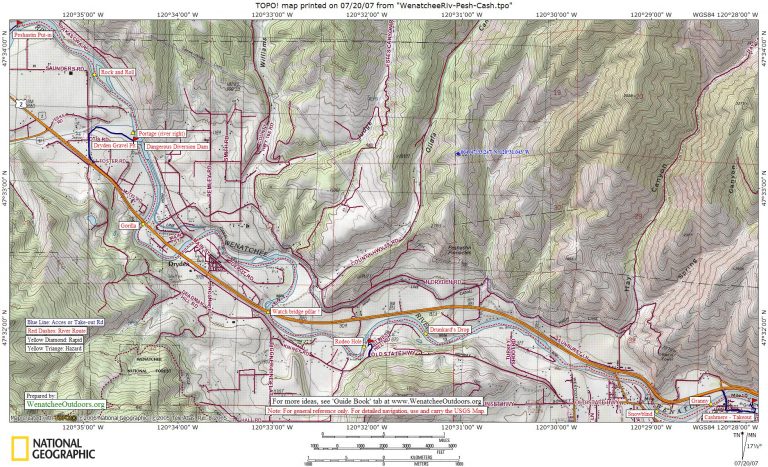
Maps. See maps below for more information.
River Levels and Gauges: Suggested minimum level of 2,500 cfs and a recommended maximum of 20,000 cfs using the USGS gauge at Monitor. The different water levels referenced in the rapid descriptions (below) are based on the Monitor Gauge.

Photo left, surfing near Happy Wave
Put-Ins. Depending on whether you want a longer or shorter run, or a run featuring more playing, there are a few popular put-ins along this stretch of river. This link to Wenatchee River Access Points describes more put-ins and take-outs than we feature here.
- The most popular access points for boaters wanting to cruise the length of the river is the Washington Department of Fish and Wildlife site at the town of Peshastin. Follow Highway 2 to milepost 103.6. At the Peshastin stoplight, leave Highway 2 and cross the bridge spanning the Wenatchee River (Main Street) that leads to Peshastin. Just across the bridge, turn right on School Street. In about 0.3 miles, the name changes to River Road. Keep driving a few blocks to the end of the road and you’ll find a parking lot, toilet, and easy access to the river. A Fish & Wildlife permit is required for parking. This put-in is on the edge of a residential neighborhood and has been nearly closed in the past because of unruly behavior on the part of river runners. Please drive slowly, don’t litter, keep the noise level down, and use discretion when changing clothes.
- The Dryden Gravel Pit put-in gives a slightly shorter river run (1.5 miles shorter) than putting in at Peshastin. About 0.4 miles southeast of the Highway 2 / Highway 97 Junction (Big Y) and, at milepost 105.1, turn northeast onto Saunders Road. Immediately veer left and drive 0.3 miles. Just before the bridge over Peshastin Creek, turn right on a DOT gravel road with a small sign reading Dryden Gravel Pit. Follow this road 0.4 miles until its end and put in just below the Dryden diversion dam. As of 2010, permits were not required to park here.
- The Rodeo Hole access is another Dept of Fish and Wildlife site. To access from the east: Turn left off Highway 2 into Cashmere at milepost 111.1 on Aplets Way (there’s a traffic light on Highway 2). Go through a blinking light and, just after crossing the railroad tracks, turn right on Sunset Avenue. Drive 3.2 miles and, after a long guard rail, watch for a house with a blue metal roof (house number is 7444), turn right into the lower driveway, watching for orchard vehicles. After 0.1 mile, go left when the road forks and drive another 100 yards into a primitive parking area with a pit toilet. It’s about a 75-yard walk to the river along a trail. You’ll need a parking permit from the Washington Department of Fish and Wildlife (violators occasionally ticketed). To access from the west: Turn right off Highway 2 at milepost 106.5 (Johnson Canyon Road) and then immediately turn left onto Stine Hill Road and follow this 1.7 miles to the gravel access road described above leading down to the primitive parking area.
Take-Out. Use Riverfront Park (on river right) at the town of Cashmere. Follow Highway 2 to milepost 111.1. Turn onto Aplets Way and cross the bridge leading into Cashmere. At the second or third left after crossing the bridge (Pleasant Ave), turn left and head east for two to three blocks. The street takes a jog but leads to Riverside Park. Turn left into the park. The boat ramp is located in the upstream portion of the park. If you want to float farther than Cashmere, there’s another takeout at a campground 4.5 miles downstream on river left at Wenatchee River County Park in Monitor. Between Cashmere and Monitor there are only Class 1 and 2 rapids.
Trip Instructions and Rapid Descriptions:
-
If you start at Peshastin, Rock and Roll, located about 1 mile downstream from the put-in, will be the first large rapid (class III) and forms on the right side of an island splitting the river. This 200-yard-long rapid, like many on the Wenatchee, dishes up big waves and a big hole (the hole forming right of center is known as Satan’s Eyeball). At most water levels most paddlers start in the center of the river and move toward river left to miss Satan’s Eyeball.
-
The river flows swiftly on down to the diversion dam where Peshastin Creek enters. The re-circulating hydraulics at the base of this dam is a drowning hazard (especially on river right). The concrete structure of the dam is easy to see from upstream and the portage trail is on river right. A sneak route develops around to the left at some water levels but don’t try it unless you know the line, have the skills to run it, and understand (and accept) the dangers associated with this dam. Here’s a report that makes a case to modify the dam.
-
The downstream side of the dam is where boaters putting in at the Dryden Gravel Pit will access the river. The next major rapid, Gorilla Falls, is 0.75 miles downstream and forms directly under the first highway bridge you float under. Like other Class 2+ to 3 rapids you’ll be running, it has big waves and, at some water levels, holes form to the side of the main tongue of water. That main tongue is the best line.
-
There’s quite a succession of rollicking rapids now that offer good rides but that are easy to scout on the fly. Kayakers will find a few good play spots and surf spots in the next few miles.
-
One well-visited play spot is 3.4 river miles downstream of Gorilla at Rodeo Hole. It’s just upstream of a railroad bridge and you’ll recognize the spot by the sandstone slabs flanking the water on river right. On weekends and hot summer days there’s often quite a scene of picnickers, swimmers, rafters, and playboaters here. There are waves and a hole on river right that come in and out of shape at different water levels. There’s also a wide wave upstream of these features running from the center of the river toward river left. Eddies on both sides of the river let you keep re-entering these features. Between 8,000 to 10,000 cfs, a nice wave (glassy at some levels, with a nice foam pile at others) forms on the river right. From 10,200 to 16,000 or 17,000 cfs, the wave becomes a big hole. Intermediate kayakers will find good features to practice on even at water levels down to about 4,000 cfs.
-
Drunkard’s Drop is 0.6 miles below Rodeo Hole and is recognized by the 30-foot-high, buff-colored cliff on the left and the chaotic, big waves beside the cliff. At most water levels you’re safe and get a big-wave ride running the center and you can sneak some of the jolt by staying right. Running left can deliver a rough but safe ride at some water levels and have some munchie holes at other levels – it’s a line best chosen when you know the river better. When water levels are high (10,200 to 15,000 cfs), there’s a wave at the bottom of Drunkard’s on river left that has an eddy allowing you to recycle the wave. The wave is called Trinity and Adam McKenney, owner of Leavenworth Mountain Sports, considers it one of the best waves in the country. Trinity is bouncier and rougher at higher levels, smoother at the lower range listed, and disappears as a surfing wave as water levels drop below 10,000 cfs. At the same levels that Trinity is good, a glassy wave forms at the top of Drunkard’s Drop that is excellent to surf. Unfortunately, this wave cannot be re-entered once you’re past it. At lower river levels (5,000 to 6,500 cfs) an interesting wave forms on river right about half way through Drunkard’s Drop. You can catch this wave after shooting the rapid via an eddy on river right. Note2012 Update: Over the winter of 2012, a big block that fell off of the cliff on river left, fell into this rapid and changed its characteristics. Water that is getting pushed to river right by the boulder is creating a fun wave train a bit right of center. Jean Luc of Leavenworth Mountain Sports reports that most of the high-water play features of the rapid are, unfortunately, changed or gone. The Trinity wave has not been forming in the same way and, at most high-water levels, has been hard to stay on. Advanced boaters have been boofing right over the new boulder at flows between 11,000 and 14,000 cfs. Below 11,000 cfs the hole below the boulder is looking more retentive and shallow, and even advanced boaters are leery about getting window-shaded in here.
-
Turkey Shoot or Gun Club Wave is a wave/hole that forms along the left river bank about 0.8 miles downstream of Drunkard’s. A wave or weak hole is almost always present and, at lower flows (3,000 to 5,000 cfs), it’s an excellent place for less experienced boaters to cut their teeth learning how to surf, side surf, and back surf. The wave is not that great at high flows (above 13,000 cfs).
-
Snowblind is 1.5 miles downstream of Turkey Shoot wave and comes shortly after floating under the Goodwin Road Bridge leading to Cashmere. This is the most chaotic rapid on this section of river and there are boulders, spillovers, waves, and holes forming at different water levels. At most water levels, staying fairly far left offers the safest and easiest line. At high water levels (17,000 to 23,000 cfs), look for Goliath, a wave train at the top of the rapid on river right that has monstrous standing waves. These huge waves provide exciting surfing and hard-core boaters work the waves, exit on river right, and walk back upstream for another circuit. At water levels below where Goliath forms, there are good glassy waves to surf left of center as you approach the rapid. These often look like nothing from a distance but actually have five-foot troughs. They form at many water levels but are best between 9,000 and 15,000 cfs. At many medium to medium-high levels (6,000 to 12,000 cfs) there are excellent surfing waves in the center of the river as you shoot the rapid. Hawaii 5-0 is one of these waves and it forms a curling wave that looks like a pipeline. It sits a bit left of center about halfway through the rapid and kayakers who catch it can park here for 15 minutes. At lower water levels, Snowblind forms two nasty holes near the bottom of the rapid that are very retentive. One hole (Snowblower) is left of center; the other (Safeway) is right of center. Safeway is so named because if you wash in you’re likely to end up swimming to escape—then you can go get a beer at the Safeway while you figure out how to retrieve your boat, which will still be rolling around in the hole. Snowblower isn’t quite as retentive but it munches many boaters as well. As of 2009, these holes were at their worst between 3,000 and 7,000 cfs. One day they may be quite harmless and the next, as the water drops, they may be man-eaters.
-
Granny’s Rapid is 0.4 miles downstream of Snowblind and at most water levels it delivers more punch than any rapid on this portion of the Wenatchee. Regardless of the water level, huge powerful waves form here. You can sneak the rapid staying well left of the wave train but, for the best ride, shoot down the center of the rapid or stay just slightly right of center so that you’re less likely to wash into Suffocator (a hole) at the bottom of the rapid. Playboaters like the wave/hole that forms about a third of the way down the rapid slightly left of the biggest waves. You can catch the flat water on the far left and ferry into the wave/hole. As of 2010, this is surfable at 5,000 to 8000 cfs, gets munchie around 9,000 cfs, and above 10,000 cfs turns into a glassy wave with a foam pile on top. There used to be more of an eddy below the wave and you could walk the gravel island back for a repeat performance. The gravel island is washing out and around 9,100 cfs you walk back up, but not at higher levels. Suffocator was a retentive hole that used to form at the bottom of Granny’s slightly left of center. This hole has changed recently and doesn’t seem to be forming at most water levels. Now big, irregular waves are usually breaking at the bottom of the rapid. These waves are moving targets but sometimes kayakers can hit them when they’re just the right shape and get a good ride.
-
Take-Out. Immediately below Granny you’ll cross under one of the Cashmere bridges. Stay on river right and in a few hundred yards look for the takeout ramp at Riverside Park. There’s an eddy to catch in the midst of a riffle and, if you’re not paying attention, it’s easy to miss.
 John Marshall Photo Right: Paul Milem gets a squirt at Drunkard’s Drop
Low Water Conditions:
Rafters tend to give up on this section of the Wenatchee somewhere between 2,500 and 2,000 cfs, but paddlers (kayakers and canoeists) in plastic boats will still find adequate water and enjoyable waves and foam piles to play in at 1,800 to 1,900 cfs. Below these levels, the river is still runnable by kayakers and canoeists, but a little more challenging. We kayaked the river at 1,550 cfs (Monitor gauge) and still found this stretch of river awfully fun. Yes, there were places where it was hard to avoid dragging bottom or playing bumper cars with a few rocks, but we found good play features at the following locations (descriptions below correspond to this river map):
1- Cave Rapid. Medium-small wave on river right serviced by small eddy. About 1/3 of the way down the rapid and immediately across from the cave.
2- Train Wave or Trestle Wave. Medium-sized wave and foam pile on river right immediately past train trestle about 150 yards upstream of Killer Pillar. Serviced by small eddy.
2- Killer Pillar. Medium-sized wave in middle of rapid. Catch on the fly, no eddy. Also a shallow foam pile to surf about 50 feet upstream of the first bridge pillar from which this rapid gets its name..
3- Middle Rodeo Hole. Medium-small wave and foam pile on river right about half-way down rapid. Serviced by good eddy. Very shallow.
3- Lower Rodeo Hole. Small wave on river left at bottom of rapid. Serviced by eddy.
4- Drunkards Drop. Medium-sized hole and wave at very bottom of rapid on river left. Serviced by small eddy. Eddy is a pain but the wave is a fun ride.
5- Rookie’s Rock. Many ledges with small waves to catch about 1/4-mile upstream of Turkey Shoot Wave. First wave on river left is serviced by good eddy.
6- Snowblind Rapid. Many waves in the rapid but they form around very shallow shelves — bad place to tip. Nice medium-sized wave right of center at bottom of rapid – catch from eddy forming behind hole in center of river.
7a – Upper Granny. Large wave and foam pile on river right. Then another large foam pile just slightly lower in center of river (potential helmet-banging rock reported if you tip in this second foam pile).
7b – Middle Granny. About half or two thirds of the way down, nice green wave on river left with foam pile out in center.
7c- Lower Granny. Several medium and medium-small waves and foam piles to catch on the fly on river left. No eddies to service any of these waves but easy to walk the boat up left bank to re-run most of the rapid.
Warning. River features (like waves and holes) and how they respond at different water levels can change from season to season. Our information applies to what was observed throughout 2009 and through June in 2010. Take this information with a healthy grain of salt, knowing that what was observed about waves and holes in 2009 and early 2010 is not an exact prediction of how that feature will behave in the future. With time some features become more retentive than they had been in the past, others become less retentive. As always, it’s up to you to study these features as you float the river and decide for yourself whether you’re boating skills will allow you safe playing and safe passage.
Cons. Don’t expect a remote or wilderness section of river–highway and railroad bridges cross this segment of the Wenatchee multiple time. Many homes and a few trailer courts also flank the river. And then there’s the scene from all the rafters and paddlers. Exhibitionists looking for an audience will thrive from that scene, timid boaters will not.
Additional Information. For a complete list of access points on the Wenatchee River, check out this information prepared by Richard and Kathy Spencer
Recommended Season: Spring and early summer. Like most rivers, this varies from year to year according to the winter snowpack and summer temperatures. As a general rule, boaters should monitor the water levels from March through July.
Reporters: Information for this guidebook entry (prepared in July of 2007 and updated 2010) was supplied by the American Whitewater website, John Marshall, Andy Dappen, Paul Milem, and Adam McKenney.
More Info: See 1) A Guide to the Whitewater Rivers of Washington by Bennett and Bennett, Swiftwater Publishing, Portland, OR. 2) Washington Whitewater by Douglas North, Mountaineers, Seattle, WA.

Photo: Jenny Colella playing at Turkey Shoot Wave
Leave It Better Than You Found It: This should be every outdoor user’s goal. Pick up trash left by others, pull some noxious weeds along your route, throw branches over unwanted spur trails, don’t ride or walk wet trails when you’re leaving ruts/footprints deeper than ¼ inch…
Disclaimer. Treat this information as recommendations, not gospel. Conditions change and those contributing these reports are volunteers–they may make mistakes or not know all the issues affecting a route. You are responsible for yourself, your actions, and your safety. If you won’t accept that responsibility, you are prohibited from using our information.