
Attractions. The paddle of the upper Wenatchee River, from where it exits Lake Wenatchee to where it meets the Highway 2 bridge at the Tumwater Campground, is an excellent stretch of river for learning the basics of paddling moving water. At most water levels, the current moves along well, but the hydraulics (eddies, waves, shear lines) are manageable by intermediate paddlers or beginners under the supervision of experienced boaters. There are many little riffles to learn how moving water affects a canoe and many rocks to maneuver around. Scenically the river is very pleasant, and you’ll pass through forests, under sandstone cliffs, and alongside sand bars. Much of the paddle has cabins dotting the shoreline, but the last three to four miles of the trip is unpopulated and pristine.
 Distances. From Lake Wenatchee State Park to the bridges at Plain is 8 river miles. From these bridges to the Tumwater Campground is 10.7 miles. Total distance is 18.7 miles. At medium water levels it requires 3.5 to 4 hours of paddling time to complete the distance (add your stoppage time to figure out the time you’ll need).
Elevation. Lake Wenatchee: 1868 feet. Tumwater Campground: 1650 feet. Average grade: 12 feet per mile.
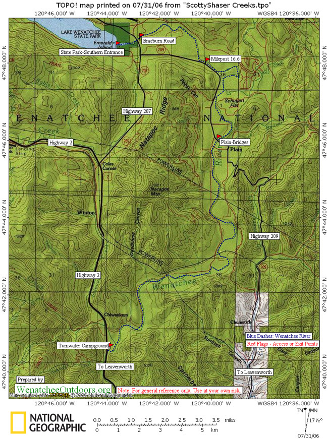
Maps. See map below for more information.
Difficulty: 1+ or 2-/ . Many Class 1 or 1+ riffles. At some water levels, some of these bump up to grade 2- or 2. At many water levels the largest rapid (often 2- or 2 in size) is several miles from the take out (near the last cabins to be seen) where the river takes a little drop while hooking left. No effort is taken to identify these riffles and small rapids–paddlers who are suitably matched for this stretch of water (intermediates or beginners accompanied by experienced boaters) will be able to scout the water on the go.
 Water Levels. Water levels between 1500 and 2000 cfs (Plain gauge) are particularly good for this stretch of river. Below 1200 cfs, be prepared to start hitting a few rocks and scraping gravel bars. This trip reporter does not know what the river is like at higher water levels–if you know, report in and we’ll add your information to this report. The link to the river gauge at Plain is listed at the top of the page. Water gauge link.
Put-Ins
There are several places to get on the river.
1) For the longest paddle put on at Wenatchee Lake State Park. From Coles Corner at Highway 2, drive about 4 miles NE on Highway 207 and then turn left into the south entrance of the State Park. There is a $5/day/vehicle parking fee.
2) Braeburn Road Access. From Coles Corner at Highway 2, drive about 5 miles NE on Highs 207 and 209. Just before the Highway 209 (north) crosses the Wenatchee River turn right (east) onto Braeburn Road and look for a trail down to the river. Make sure you don’t block the road or the driveways of the residents living along the road.
3) To shorten the paddle about 3 miles, put in at milepost 16.6 along Highway 209. From Coles Corner at Highway 2, drive a little over 4 miles NE on Highway 207 and then turn right onto Highway 209 and drive east. Pay attention to the milepost markers and at mile 16.6 park on the south shoulder of the road. Cross the highway and follow a trail down to a bushy put-in.
4) To shorten the paddle about 8 miles, put in at Plain where there are two bridges. Highway 209 crosses the river by Plain and on the west side of the bridge you can park on the northern shoulder and put in on river right just above the bridge. The access on the east side of this bridge is now closed. A trail by the old bridge downriver of the 209 bridge can also be used to access the river. Turn south off of Highway 209 a short ways northwest of the Highway 209 bridge; then follow River Road south for a quarter mile.
Take-Out. Tumwater Campground is located 8.5 miles west of Leavenworth at milepost 90.5 along Highway 2. Leave vehicles in the campground’s day-use parking lot. Exit the water up-river of the bridge on river right. There is a steep trail up from the river bank very close to the bridge or a much gentler trail another 100 yards upriver. You can also go under the bridge and immediately exit on river left and then carry your boats up to the highway. NOTE: Do not keep paddling beyond the bridge unless you are an expert.
2013 update about the take-out at the Highway 2 bridge. While the bridge is under construction:
- Old take-outs below the bridge are blocked by this project.Also, safety concerns dictate that boaters should not pass under the bridge while work is in progress.
- While bridge construction is taking place, take out upstream of the bridge – use the trail between campsites 13 and 14. Check the trail out while leaving a shuttle vehicle at the takeout. Go down to river and note what the spot will look like as you approach from the water.
- Leave your shuttle vehicle in the day-use parking area or at a campsite you reserved.
- Once the bridge construction has been completed, an access point to and from the river will be available across the highway from the Tumwater Campground
Hazards. Like most rivers, the power of the water increases at higher water levels, requiring more expertise for safe navigation. This stretch of river is shallow and has many rocks to maneuver around at medium and lower flows, it is best suited to plastic and Royalex boats. At any water level, those paddling fiberglass boats need to be extremely vigilant. Make sure you exit at Tumwater Campground–the river gets very treacherous below here.
Land Ownership. Private and Forest Service.
Other. In low water conditions (and on hot days), people commonly float shorter stretches of the Upper Wenatchee with inner tubes or department-store rafts (e.g., put in at Lake Wenatchee and get out at Plain). Use lifejackets, wear sneakers, and engage in such lunacy at your own risk.
Reporter. Andy and Jan Dappen July 2007, updated June 2009
Leave It Better Than You Found It: This should be every outdoor user’s goal. Pick up trash left by others, pull some noxious weeds along your route, throw branches over unwanted spur trails, don’t ride or walk wet trails when you’re leaving ruts/footprints deeper than ¼ inch…
Disclaimer. Treat this information as recommendations, not gospel. Conditions change and those contributing these reports are volunteers–they may make mistakes or not know all the issues affecting a route. You are responsible for yourself, your actions, and your safety. If you won’t accept that responsibility, you are prohibited from using our information.