Weather and water conditions were perfect for two old geezers (whose combined ages totaled 145) to paddle down the upper segment of the Hanford Reach. Skies were clear, temperatures warm, but not sweltering, and, most important of all, there was NO wind and a BRISK current.
The Hanford Reach is billed as the last free-flowing stretch of the Columbia River above tide water in the United States. That it is, but it is NOT, as some hyperbolically claim, in a natural state unchanged since the days of David Thompson.
The flow, for example, is regulated by Priest Rapids Dam just upstream and varies quite drastically according to the arcane exigencies of power generation. This was graphically demonstrated to us when we returned to the put-in after positioning our shuttle vehicle and found our previously high and dry kayaks about to float downstream. A close call for a couple of dummies!
The other obvious alteration affecting the natural state of the river is the presence of scattered nuclear facilities on the right bank which contrast starkly with the wilder, undeveloped left bank of the river.
That being said the trip provides a scenic and memorable current-assisted paddle down a mighty river through a remnant of the sage brush steppe that once covered much of the Columbia Basin.
The White Bluffs located in the second half of the run resemble canyons of the desert southwest with multiple layers of sedimentary rock of various hues from red to brilliant white. This rock contrasts sharply with the otherwise ubiquitous basalt of the Columbia Basin.
The Reach is also a good fishery for fall Chinook and steelhead and during our trip a multitude of fishermen were deployed in hopes of snagging these finny prizes.
Details, Details: Hanford Reach
Skill: 2 (intermediate). Fitness: 2+ (strong intermediate).
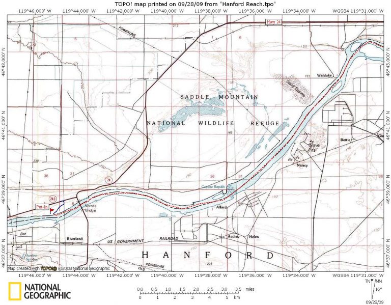
Put-in. Use the fishing access just upstream from Vernita Bridge on the north side of the river (river mile 389).
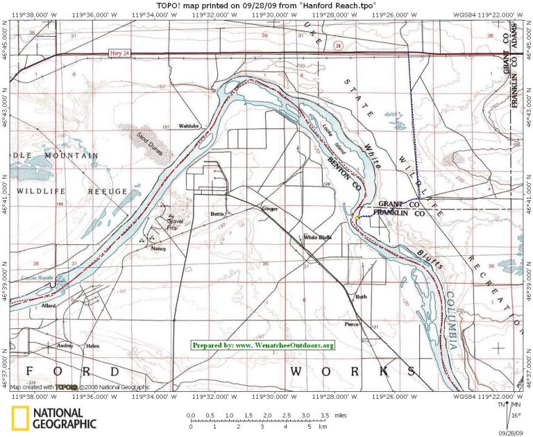
Take-out. Use the White Bluffs boat launch. To reach this, drive 19 miles on State Route 24. Just east of mile post 63, turn right on a gravel washboard road into the Wahluke Wildlife Area. Follow this 4 miles to an intersection marked by a sign indicating White Bluff Boat Launch. Turn right on this road and drive another 1.75 miles to the boat launch (river mile 370).
Shuttle. If you use a bike, use a mountain bike or a cross bike. Due to the gravel roads and the non-existent shoulders on SR 24,a road bike is not recommended.
River distance: 19 miles.
Paddling time are flow and wind dependent. Our time: 2hours, 50 minutes.
Camping. Not available on this stretch of river.
Hazards. Negligible (a few minor riffles, a greater number of powerboat wakes).
Other considerations and wind. The 35-mile trip from the Vernita Bridge to the Ringold take-out farther downstream (river mile 354) would be easily doable as a day trip under the ideal conditions we encountered. With the longer drive, longer shuttle, and the real possibility of upstream winds, budget a long day to do it. For info on the actual and forecasted winds, check this link at iwindsurf.com
Maps: See maps below for more information.
Reporters. Dave and Jerry Jaecks.
Leave It Better Than You found It. This should be every user’s goal. Pick up trash left by others, pull noxious weeds along your route, disperse old fire rings, throw branches over unwanted spur trails…
Disclaimer. Treat this information as recommendations, not gospel. Conditions change and those contributing these reports are volunteers–they may make mistakes or not know all the issues affecting a route. You are responsible for yourself, your actions, and your safety. If you won’t accept that responsibility, you are prohibited from using our information.