
Skill: 1 (beginner)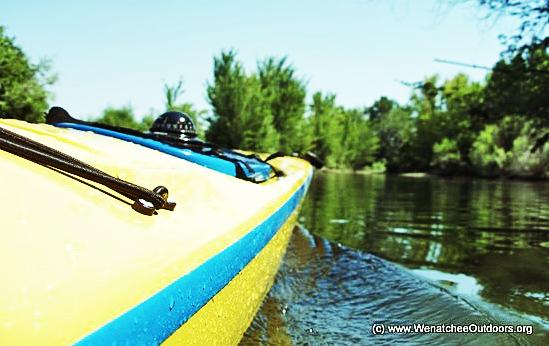
Fitness: 1-2 (easy to intermediate depending on how far you go and how hard you push yourself)
Distance. 4 to 5 miles round trip.
Attractions. Paddling through the estuary, sloughs, and islands at the confluence of the Wenatchee and Columbia rivers is one of the hidden outdoor gems of Wenatchee. Though virtually in the city’s limits, this area feels wild and a world removed from town. The noise and structures of the city disappear. Birdlife and wildlife abound. And you’re likely to feel an immediate calm as you enter these backwaters. For canoeists and flat-water kayakers, this is the paddling equivalent to walking or riding the east side of the Loop Trail.
Hazards. This is flat water paddling, but there is some current from both the Columbia and Wenatchee rivers– especially if you paddle up toward the highway and irrigation bridges. Moving water is always tricky and potentially hazardous to novices– especially in cold weather/cold water conditions. Get some instruction/coaching from experienced paddlers if you are new to the sport.
Access.
–Start this paddle from either Riverfront Park or the Linden Tree Area in Wenatchee. To reach Riverfront Park, drive east on Fifth Street in Wenatchee until it terminates at Riverfront Park. Turn left at road’s end and drive a few hundred yards north through parking lots. Park as far north as possible. From here you can walk 50 to 75 yards down to the river where you’ll see a good lawn and sand beach (if the water is lower) to exit the Columbia River.
–To reach the Linden Tree Area, follow Ninth Street toward the Columbia (east) until the arterial hooks hard to the left. Go straight on the smaller road and enter the Linden Tree Area. Park and then either carry your boat straight toward the river down a steeper trail to a rocky beach. Or carry your boat along the Loop Trail heading left of the cars. Cross a bridge and then turn to the right and walk to the water where you can launch in a shaded inlet or on the Wenatchee Row and Paddle Club’s dock. The barn you pass is the boat house belonging to the paddle club.
-You can also put in at Walla Walla Point Park, which can be shown from this map.

Trip Instructions. Paddle upstream, remaining close to the shore of the Columbia River. Shortly beyond the swimming area connected to Walla Walla Point Park, enter a slough and wind your way back through the estuary, following water that has some current. Eventually you’ll come out of the sloughs and into the Wenatchee River. Turn left and head upriver, passing under a number of bridges, first the pedestrian bridge that’s part of the Loop, then the railroad bridge, then the highway bridge, and finally the irrigation bridge. If you paddle to the far side of the river (river left as you face downstream) after going under the railroad bridge, you’ll enter another system of sloughs. Follow water that has some current and you’ll wander through little channels choked with bird life. You’re also quite likely to see beaver and deer, and you may see martins or mink. If you keep following the left-trending channels, you’ll enter the Columbia River a few hundred yards downstream of the Confluence Park swimming area. Now, either bee-line back to your car following the Columbia River, or head back into the Wenatchee River estuary and find other little channels to explore as you wind your way back toward your starting point.
 Land Designation. The Chelan County PUD maintains much of the west side of the loop not part of the Wenatchee River. Here’s an excellent schematic map posted at their website.
Fees/Permits. None required.
Other. The Wenatchee Row and Paddle Club is an excellent and affordable local club for individuals and families interested in getting more involved with paddling (or rowing).
Leave It Better Than You Found It. This should be every user’s goal. Pick up trash left by others, pull noxious weeds along your route, disperse old fire rings, throw branches over unwanted spur trails…
Disclaimer. Treat this information as recommendations, not gospel. Conditions change and those contributing these reports are volunteers–they may make mistakes or not know all the issues affecting a route. You are responsible for yourself, your actions, and your safety. If you won’t accept that responsibility, you are prohibited from using our information.
