SummitPost.org says, “Clark Mountain is one of the highest peaks in the North-Central Cascades of Washington. It is roughly 50th highest in the state depending on the list you go by. Since it is the farthest south of all the northern Washington Top 100 peaks, there are no nearby high peaks to its south. As such, when you get to its top, it seems to tower over the lower hills to its south much like Mt. Rainier towers over its surroundings. At least that’s the impression I got. Seven miles to the WNW of Clark is the stratovolcano Glacier Peak (10,541 ft), of which many a summitposter is familiar. Clark and Glacier are connected by a long high ridge. This ridge is known as the DaKobed Range. (DaKobed means “Great Parent” and was an indian name for Glacier Peak.) Other major peaks along this ridge include Luahna Peak (est. 8,450 ft), Chalangin Peak (est. 8,350 ft), Tenpeak Mountain (8,281 ft), and the Kololo Peaks (8,200+ ft).”
“Clark Mountain is characterized by rugged, open south and west sides and glaciated north and east flanks. The vertical drop from the summit to the White River on the southwest is an impressive 6,100 ft in about two miles. The drop to the northeast to Napeequa River is 4,100 feet in about two miles. There are two important glaciers eating away at Clark. The first of these is the Walrus Glacier (shown as the Clark Glacier on maps) on the east. It is about 3/10th of a square mile in area. When it is in shape, this glacier is a semi-popular basic glacier climb for the Mountaineers. The second but larger glacier is the Richardson (1.4 sq. mi.) on the northern flanks. The Richardson Glacier pinches in between Clark and Luahna and extends up to Clark on a second tier.”
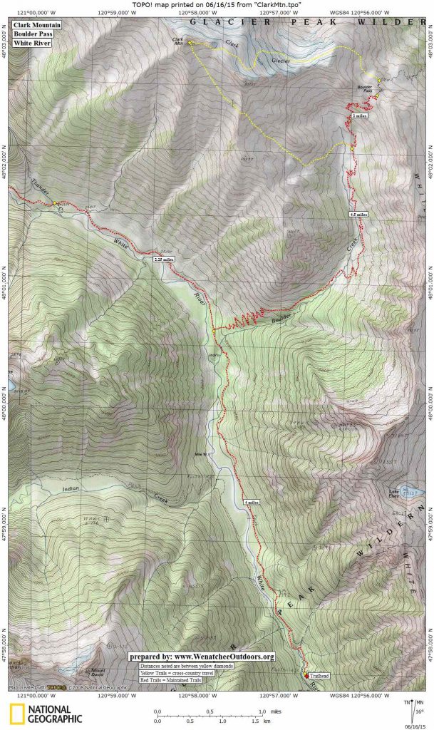
Boulder Pass (6,330 feet) meanwhile is the pass capping the top of Boulder Creek that is located a few linear miles east of Clark Mountain. The open terrain and vegetation of the pass gives an airy view out over the peaks confining both the White and Napeequa Rivers. It’s a worthy destination for a long day trip or an overnight backpacking trip.
Distance: Clark Mountain 11.5 miles one way. Boulder Pass 10.5 miles one way
Elevation Gain: Clark Mountain 6,500 vertical feet. Boulder Pass: 4,000 vertical feet.
Activities: Mountaineering and hiking.
Skill: Clark Mountain is, technically, not a difficult peak. Mountaineers would rate it a 1+ advance beginner. Hikers on the other hand will find this a hike suited to advanced hikers (difficulty of 3). The hike to Boulder Pass, meanwhile is intermediate in difficulty (difficulty of 2).
Fitness: 3 (advanced)
Access:
- Drive west on Highway 2 from Leavenworth about 14 miles to Cole’s Corner (Milepost 84.7) and turn onto Highway 207 heading toward Lake Wenatchee.
- MP 4.4: After crossing the Wenatchee River, the road forks–stay left keeping on the Lake Wenatchee Highway
- MP 10.6: Fork to the right onto the White River Road (aka Road 6400).
- Drive another 10.2 miles on road 6400 until it ends at the trailhead (elevation here: 2,300 feet). Northwest Forest Pass required to park at the trailhead.

Trip Instructions:
Clark Mountain. The easiest climb of Clark Mountain is non-technical but does involve some careful navigation to find. Start by hiking up the White River Trail (#1507) about 4 miles and turning right (east) on the Boulder Creek Trail leading toward Boulder Pass. About 4.5 miles up this trail and at 5,000-foot level head up an old sheepherder’s trail westward to about the 5,600- or 5,700-foot level. Leave the sheepherder’s trail now and ascend open terrain (heather) in a NNW direction to the southern ridge coming off of the SE peak of Clark (Pt. 8373). It is important to find the one and only easy gully leading down off this ridge that drops a few hundred feet into the south basin of Clark. This gully leaves the crest at about 7,200 or 7,300 foot level. Drop down the gully a couple of hundred feet and then contour the upper South Basin on broken rock and some perennial snow to the final south ridge. From car to summit is about 11.5 miles (one way) and roughly a 6,500 foot-vertical gain. For a good trip report for this route, see Eric’s Base Camp. Our map also shows the route to climb Clark Mountain via the Walrus Glacier (crampons, ice axe, and glacier travel gear recommended).
Boulder Pass. From the trailhead follow the White River Trail (#1507) about 4 miles and then turn right (east) on the Boulder Creek Trail (#1562). Follow this for 6.5 uphill miles to the pass. There is scenic camping at the pass.
Map: See map below for more information.
Nearest Town: Leavenworth-Plain
More Info. See this listing at SummitPost.org for more about climbing Clark Mountain.
Fees/Permits: A Northwest Forest Pass is needed to park at the trailhead.
Land Ownership: Forest Service. Much of the route is within the Glacier Peak Wilderness.
Leave It Better than You Found It. This should be every user’s goal. Pick up trash left by others, pull noxious weeds along your route, throw branches over unwanted spur trails, etc.
Disclaimer. Treat this information as recommendations, not gospel. Conditions change and those contributing these reports are volunteers–they may make mistakes or not know all the issues affecting a route. You are responsible for yourself, your actions, and your safety. If you won’t accept that responsibility, you are prohibited from using our information.