 A big peak suitable for fit hikers that delivers expansive and spectacular views of Glacier Peak, White River, and the North Cascades. This peak is also one of the few in the state with a hiking trail that lets you bag a vertical mile of elevation in one fell swoop. It’s one of those true ‘gain through pain’ experiences—one of those hikes you’ll be glad you did, but you may question your sanity during the actual grind.
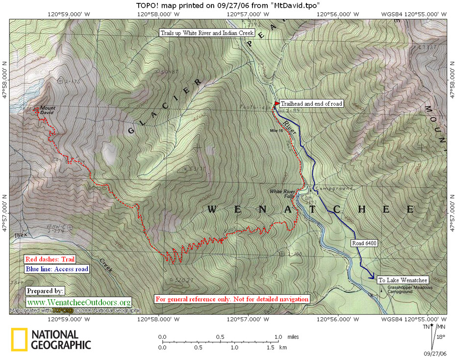
Maps: See the map below for more information (USGS 7.5-Minute Series: Mt. David, WA).
Note: use ‘Print Preview’ before printing to properly scale this map to a full sheet of paper.
Activity: Hiking, Climbing-Mountaineering
Nearest Town: Lake Wenatchee
Skill Level: Hiking- 2; Mountaineering-1
Fitness Level: Hiking-3; Mountaineering-3
Distance: 16 miles round trip
Elevation: Oh the pain: it’s a 5200-vertical-foot gain to the 7,431-foot summit.
Access:
- Drive west on Highway 2 from Leavenworth about 14 miles to Cole’s Corner (Milepost 84.7) and turn onto Highway 207 heading toward Lake Wenatchee.
- MP 4.4: After crossing the Wenatchee River, the road forks–stay left keeping on the Lake Wenatchee Highway
- MP 10.6: Fork to the right onto the White River Road (aka Road 6400).
- Drive another 10.2 miles on road 6400 until it ends at the trailhead (elevation here: 2,300 feet).
Trip Instructions:
–Immediately cross the White River on the big bridge, following signs for the Indian Creek Trail. On the far side of the river go upstream for about 50 yards then branch left on a trail heading downstream and signed for Mt. David and Panther Creek.
— In a mile, turn right off the trail paralleling the river onto a trail signed for Mt. David and Panther Creek. After another quarter mile, there is another split for the Panther Creek Trail on the left (not maintained). Go right staying on the higher trail signed as the Mt. David Trail. Climb. And climb. And keep climbing. Incidentally, the last reliable water is about a third of a mile uphill from this last split. After several miles of switchbacking, you’ll reach a ridge. This is roughly the halfway mark.
— Follow the ridge in a Northwesterly direction as it climbs over some humps, and contours below others. After 3.5 miles of ridge walking the trail ends on the summit. The trail along the ridge is good but it is quite narrow and contours very steep slopes so the consequences of stumbling and stepping off the trail could be serious at times. Also, during the last several hundred vertical feet of gain, the trail makes tight zig zags up a narrow system of little ledges. These ledges are easy to walk but the path is less distinct and you can see the spur trails and footprints where lots of people have wandered off route. Pay attention, and if the route suddenly has you needing to use your hands to scramble, backtrack a little and look for an easier way.
–The trail ultimately ends at an airy platform that was once the location of a fire lookout. The views of Stuart, Rainier , Mt. Daniel, the Monte Cristo group, Glacier Peak, Seven Finger Jack, and Mt. Maude are in-your-face spectacular.
Cons/Hazards: Snow often sticks to the steep upper slopes until late August, so hikers should consider this a late summer and autumn hike. If you do the route earlier when snow adorns the top, you should carry (and know how to use) an ice axe and crampons. This is a dry climb in late season; carry a few quarts of water per person.
Fees/Permits: A Northwest Forest Pass is needed to park at the trailhead.
Land Ownership: Forest Service. Almost all of the route is within the Glacier Peak Wilderness.
More Info/Links: Climbers: see our link for more information about climbing Mt. David.
Trip Reporter: Andy Dappen, 9/28/06
Leave It Better than You Found It. This should be every user’s goal. Pick up trash left by others, pull noxious weeds along your route, throw branches over unwanted spur trails, etc.
Disclaimer. Treat this information as recommendations, not gospel. Conditions change and those contributing these reports are volunteers–they may make mistakes or not know all the issues affecting a route. You are responsible for yourself, your actions, and your safety. If you won’t accept that responsibility, you are prohibited from using our information.