Roger Gervin supplied the details and pictures for this post. He also posted about this destination in NW Hikers.

Much like the stubborn railroad baron for which it is named, Jim Hill Mountain stands strong and defiant, guarding it’s relatively small and out-of-the-way summit with a brutal “bushwack from hell” waiting for anyone attempting this peak in the summertime. Fortunately, the effort is not without the reward of broad views over a lesser-visited area of the Alpine Lakes Wilderness and the feeling of relief and accomplishment that comes from conquering such a thorny endeavor.
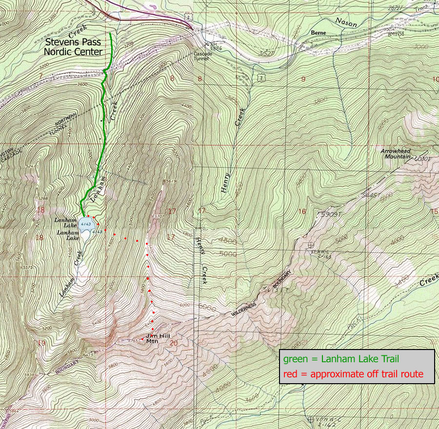
Maps. See map below for more information.
Use ‘Print Preview’ to orient/scale the map before printing.
Activity: Hiking, mountaineering.
Nearest Town: Leavenworth.

Skill: Hiking: 4 (expert). Requires good route finding and comfortable scrambling skills.
Mountaineering: 1+ to 2- (advanced beginner).
Fitness: 2+ to 3- (advanced intermediate or easy advanced).
Distance: 6 miles (round trip).
Elevation Gain: 3800 feet.
Access. From Leavenworth, drive US Highway 2 for 29 miles before turning left onto Upper Mill Creek Road (FR 6960, signed for Stevens Pass Nordic Center). Reach the parking area shortly after the turnoff. The Lanham Lake trail begins at the far east side of the lower parking area.
Trip Instructions (from Roger Gervin). We hiked the Lanham Lake Trail for 1.6 miles until we reached the lake (4134′), where we turned left crossing the outlet of the lake on a log. We then followed an obvious path for 75 yards around the east side of the lake before leaving the path and starting the half-mile bushwhack from hell up to the north ridge (5500′) of Jim Hill.

It took us 2.5 hours to complete the half-mile bushwhack, and while we still had a mile of walking and 1300 feet of elevation gain left to reach the summit, I couldn’t help but feel that we had just completed the crux of the trip. We followed the north ridge to a basin (6200′), then continued up to a notch (~6600′) between the east summit and the true summit. From there, an exposed 50 foot Class 3 scramble led to an easy Class 2 stroll over to the summit (6765′).
Fees/Permits. A Northwest Forest Pass is needed for parking at the Lanham Lake trailhead.

Leave It Better Than You Found It: This should be every outdoor user’s goal. Pick up trash left by others, pull some noxious weeds along your route, throw branches over unwanted spur trails, don’t ride or walk wet trails when you’re leaving ruts/footprints deeper than ¼ inch…
Disclaimer. Treat this information as recommendations, not gospel. Conditions change and those contributing these reports are volunteers–they may make mistakes or not know all the issues affecting a route. You are responsible for yourself, your actions, and your safety. If you won’t accept that responsibility, you are prohibited from using our information.