
Attractions. Navaho Peak is a fun walk delivering beautiful views of the Stuart Range, Miller Peak, and the peaks of the Teanaway watershed. The easiest way to summit Navaho is to access from the Teanaway River Road. This access farther away than what we often cover at this site, but Navaho Peak itself is within the WenatcheeOutdoors territory and its position and views make it prize most local hikers and peak baggers will eventually want to claim it, so we’ve included it in the guidebook. For a little inspiration of what this hike offers, see Roger Gervin’s photo gallery of Navaho Peak from June 4, 2013.
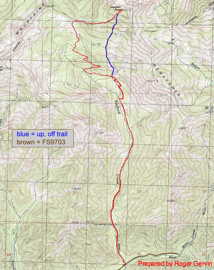
Maps. See map below for more information.
Activity. Hiking and scrambling.
Nearest Town. Cle Elum
Skill. Hiking 2 (intermediate). Mountaineering 1 (easy).
Fitness. 2
Distance. About 11 miles roundtrip
Elevation Gain. 4,276 vertical feet. Navaho Peak summit at 7223′
Recommended Seasons. Summer and Fall.
Access. Take highway 97 to the Teanaway River Road, turn right on Road 9737 just beyond a camp, and turn right to Road 9703 to the Stafford Creek Trail Head. If Road 9703 is gated, park before gate and climb around gate to reach trailhead. Sufficient parking areas are available before the gate. A Forest Service camp is located next to the trail head and there is a maintained outdoor toilet.
Trip Instructions.
- Hike 3.5 miles from the trailhead and cross the stream at 4800′
- Leave trail immediately after crossing stream and head steeply uphill.
- Follow to the top where you can see views of Earl Peak, Mt. Rainier, Ingalls Peak, Mt. Stuart, Sherpa Peak, and more.
Land Ownership. Okanogan-Wenatchee National Forest.
Fees/Permits. Northwest Forest Pass required.

Leave It Better than You Found It. This should be every user’s goal. Pick up trash left by others, pull noxious weeds along your route, throw branches over unwanted spur trails, etc.
Disclaimer. Treat this information as recommendations, not gospel. Conditions change and those contributing these reports are volunteers–they may make mistakes or not know all the issues affecting a route. You are responsible for yourself, your actions, and your safety. If you won’t accept that responsibility, you are prohibited from using our information.