The Plum Line of Snowgrass
by Andy Dappen
A week ago during a daylong dash up Snowgrass Mountain, we had touched the summit and beat-feet out of there to beat nightfall. When we spied that 3,000-vertical-foot plum dropping from the summit of Snowgrass Mountain into the South Fork of Chiwaukum Creek we were full of regret. Why, oh why, hadn’t we brought the camping gear so we could ski that beauty?
I was bewitched and by the following Wednesday had contacted my list of regulars to see who was game for a two-day trip to ski that line. Conditions looked primo, I told them, both weekend days we could expect mostly sunny skies.
As we all know, however, weathermen are notorious liars and by Friday evening the prognosticators had changed their tune. Now we were told, we should expect snow showers on Saturday and mostly cloudy weather on Sunday. Despite this switcheroo, Matt Dahlgreen and I remained optimistic — the weathermen had already lied to us once this week, what was to keep them from being two-faced twice?
Saturday morning as we start up the Chatter Creek Trail, the most recent forecast is still holding true: It rained overnight and it’s spitting rain now. Over the next few hours we climb out of rain and into snow. The surrounding ridgelines are gray while the air and ground around us are white. It’s not what we came for; yet it’s gorgeous.
When we reach the pass separating Chatter Creek from Index Creek, we’re temporarily stymied. The slopes below us are steep and irregular and, while they were quickly navigated last week in good light, today we’re looking into a bowl of clam chowder — there’s absolutely no resolution giving depth or texture to the difficulties below us. We spend an hour finding an easier descent where small  trees give the slope some definition.
Once down, we enjoy a late lunch. We eat slowly, hoping the clouds overhead will allow a few errant rays of sunlight to shadow the terrain around us. They don’t.
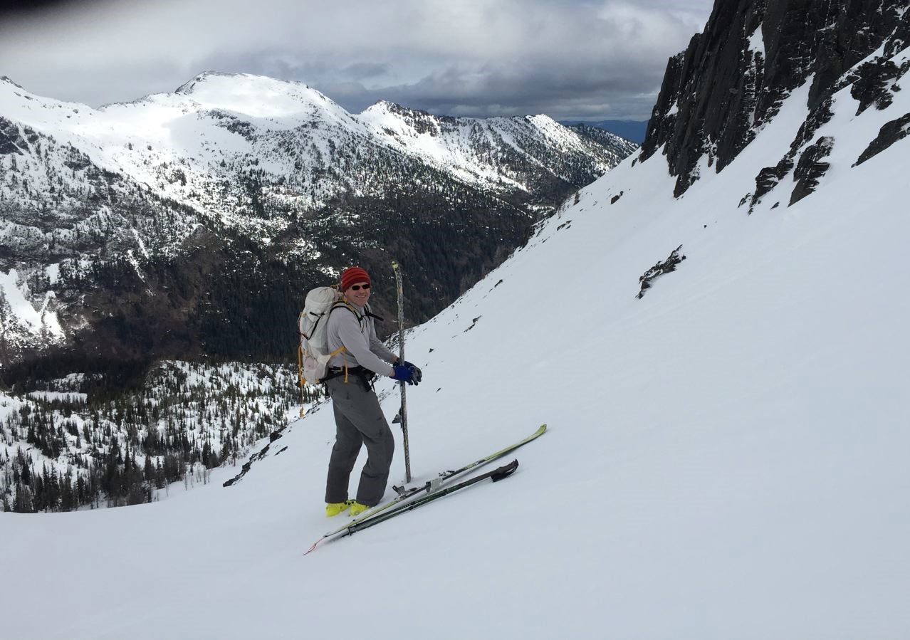
Another hour later were slightly above Lake Edna and above all trees helping define the contours of the terrain. The wind is strong and the white screen before us is completely featureless. Once while cutting the trail upward, the tips of my skis ram into the sharp rise at the bottom of a wind lip. I almost fall on my nose. Not long afterward, I plant my left pole and there’s no snow beneath it. I nearly topple off the top of another wind lip. Carrying on seems like a formula for mishap — we retreat below timberline and establish camp in the lee of a protective clump of trees. If the weather cracks during the evening, an early start will get us up Snowgrass with enough time to pick our plum line.
Around 2 a.m., I rise to better my bladder. Although high clouds still block much of the sky, the surrounding mountains are visible and the moon is bright enough to cast a shadow. Hope floats. By 5:00 a.m., clouds have consumed the mountains and the moon. Hope sinks.
We sleep in with no chores to summon us from bed. Later, we drink mochas while wrapped in the cocoons of sleeping bags – lethargy has its privileges. Around 10 a.m. the visibility takes a modest uptick and we decide to ski as high as visibility allows. If the light is too white, we’ll ski the nearby trees. But if shadows allow it, we’ll ski the next basin.
As the dirty-rotten weathermen predicted, it’s a cloudy day. Nonetheless enough sunlight spills through seams in the sky to prevent all the drunken stumbling characterizing yesterday’s 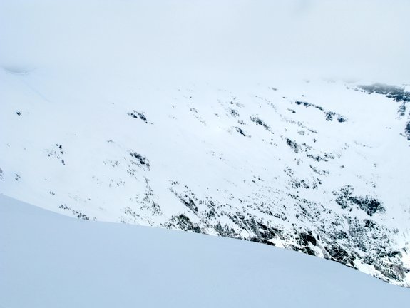 performance. We quickly find ourselves at the pass north of Lake Edna looking at the terrain we had intended to reach yesterday.
Photo: Snowgrass Mountain hiding herself in the clouds.
In the distance we can see the bottom half of our plum line on Snowgrass – she’s shapely and curvy. The upper face of Snowgrass, however, is veiled by a burka of clouds.
The plum will not be picked today but the basin right below our skis stores a lot of tempting turns. And at this instant the visibility, is acceptable. We quickly strip the skins and go.
The first 800 vertical feet of treeless skiing descends a bowl rimmed with lines ranging from ‘Gentle Squeeze’ to ‘Big Squeeze’ of the adrenal glands. We follow Gentle Squeeze down to treeline. The next 1000 vertical feet of the descent winds down an open ravine strewn with truck-sized boulders and flanked by the incisors of black-rocked peaks. At times we glide through glades of needless larch; then we squirt back into ravines swept clean of such vegetative riffraff by the massive slides spilling off the neighboring peaks.
Close to the 5,100-foot level, the forest floor turns from snow to sticks. We slide to a stop feeling like we just pulled a quick one on the weatherman. We may not have harvested the plum line we came for, but the prune line we just skied was a gift.
Details, Details: Skiing (or Climbing) Snowgrass Mountain
Distance: 18 miles, round trip, to the summit.
Elevation Gain. The route yoyos over two passes and there is some elevation gain on the return trip. Total elevation gain for the round trip: 7,800 vertical feet .
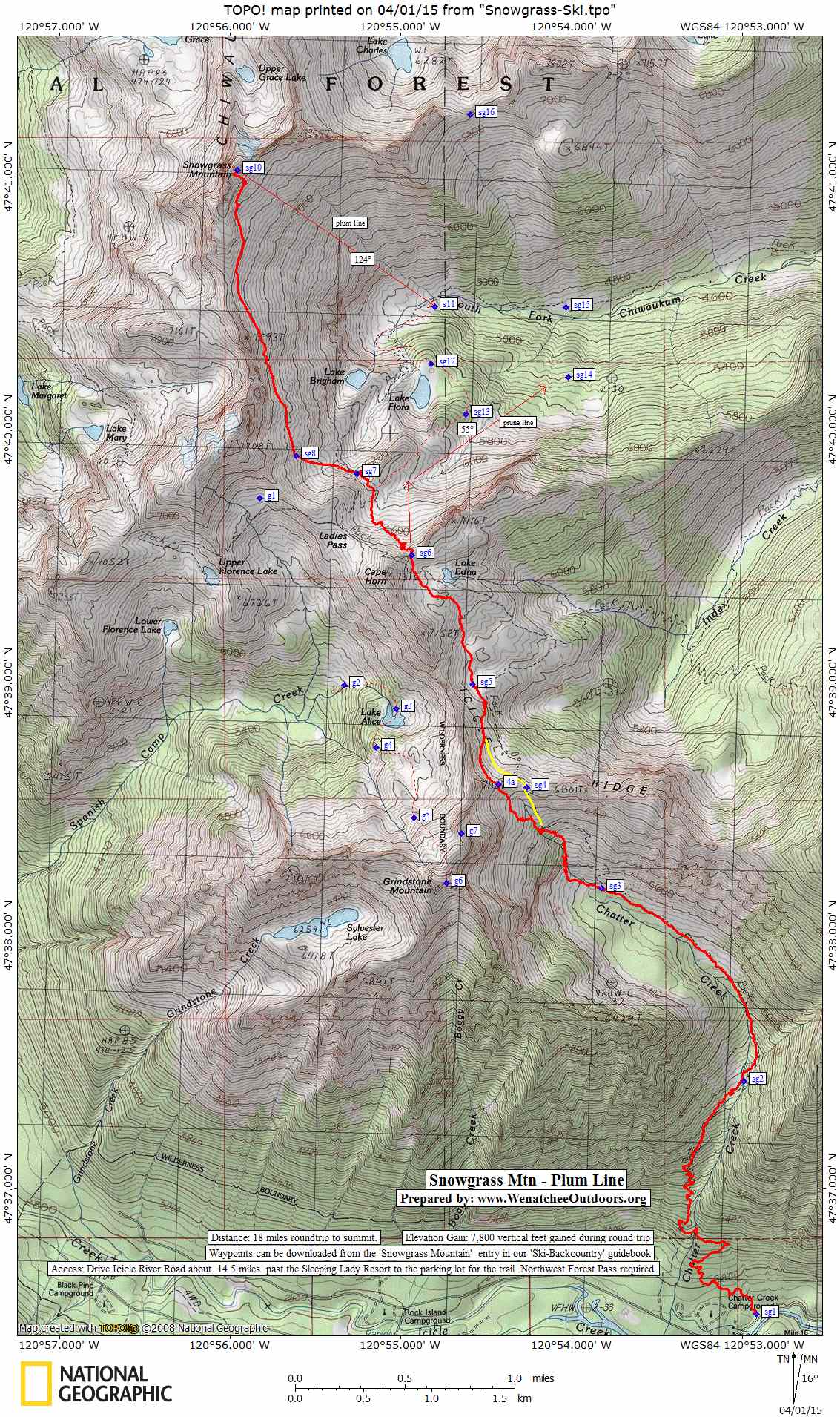
Topo Map. See our topo map below.
Difficulty. The skiing (or climbing) to the summit of Snowgrass is not technically difficult. Intermediate difficulty (2) for skiers. The plum line is an advanced intermediate (2+) or an easy advanced line (3-). The prune line we skied is a line fit for a strong intermediate skier (2+). Avalanche avoidance (in winter and spring) and route finding are the larger skills skiers need. For mountaineers the climb would be rated easy (1+).
Fitness. Advanced as a day trip, strong intermediate as an overnight trip.
 Access. From Leavenworth drive Icicle River Road about 14.5 miles past the Sleeping Lady Resort and turn right into the parking lot for the Chatter Creek Trail. If you reach the Chatter Creek Campground or the guard station, you’ve gone a little too far. A Northwest Forest Pass required to park at the trailhead.
Trip Instructions. Use the Chatter Creek Trail (starting elevation of 2,600 feet) to get up high. Cross Icicle Ridge at waypoint sg4 (6,640 feet) or 4a. Travel onward to Lake Edna and then onto the pass north of the lake (waypoint sg6). Descend to waypoint sg7 (6,250 feet) then make a big sweeping traverse of the basin forming the headwaters of the South Fork of Chiwaukum Creek to reach the summit (7,993 feet). If visibility and avalanche conditions allow it, the plum line drops from the summit in a southeasterly direction (true bearing of 124 degrees) straight down the the fall line to waypoint s11 (don’t drift too far south or you’ll be contending with cliffs). Return toward Ladies Pass by generally following the course of the summer trail.
Waypoints. Download this GPX file for the waypoints referenced on the map.
Equipment. Skiers will want the normal ski-touring kit. Ski crampons are also recommended. Climbers will want to bring crampons and an ice axe in case their visit coincides with firm conditions on the snowfields.
Hazards. There is definite avalanche hazard along this route. Know how to assess and avoid the hazard.
Leave It Better Than You Found It. This should be every outdoor user’s goal. Carry out all your trash, pick up litter left by others, pull noxious weeds found along the route, throw branches over unwanted spur trails…
Disclaimer. Treat this information as recommendations, not gospel. Conditions change, and those contributing these reports are volunteers–they may make mistakes or may not know all the issues affecting a route. You are still completely responsible for your decisions, your actions, and your safety. If you can’t live with that, you are prohibited from using our information.