
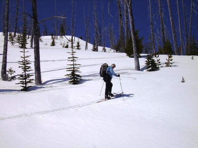
Chester Marler sent us his trip report and pictures from his May 15 skin up Wedge Mountain:

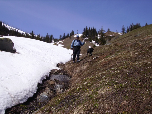
Rob Mullins and Blackie overlooking upper Snow Lake
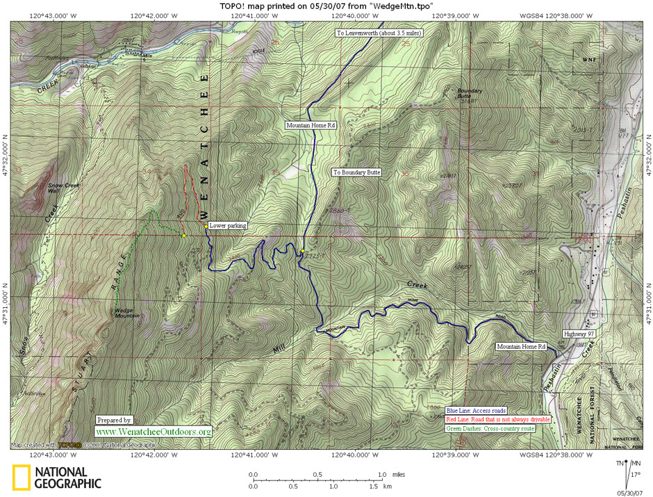
Wedge Mountain is a popular spring and summer hike, and this time of year can be a very nice ski tour and hike combined. Our May 15 trip was too early for the best flower show—later this month should be prime for balsam root—but we did enjoy carpets of spring beauties and glacier lilies. Access is via the Mountain Home Road (FS # 7300) which leaves US 97 about four miles south of the Big Y. After 2.5 miles miles take #7305 (unmarked) to the left—here is where the travel becomes a bit tougher. This section has deteriorated the last few years, and I would be hesitant to take my all-wheel-drive passenger car to road’s end. Rob had his high-clearance 4 x 4, so we drove as far as snow blocked the road—a hike of only 20 minutes to the normal parking spot. We hiked and carried our skis for the first mile or two, but skinned-up when we hit continuous snow, about an hour and one-half from our start.
 The top of Wedge is just about the end of the Stuart Range—as far east as you can be and still touch the range’s solid granite. While the approach is relatively gentle, its other flanks are quite precipitous—look to the west and see snowy McClellan, the Enchantment Basin and The Temple—to the north east and east are the warm upper Wenatchee Valley and Peshastin Cr. Quite the place, and not even a full day needed for a visit.

Note: Wedge Mountain is confusing because what the topographic map calls Wedge Mountain (a 5,860-foot peaklet visible from Leavenworth) is different than what many skiers and hikers consider Wedge Mountain to be (a 6,885-foot peak on the same ridge system but two miles southwest of the labeled peak). Both peaks offer hiking and skiing options. The higher peak (Peak 6,885) is what Rob and Chester skied in the description above and there’s more information about accessing skiing that Wedge Mountain from our backcountry skiing guidebook. That Wedge Mountain also has an informal hiking trail up it that starts near the end of Forest Road 7305 above Allen Creek and roughly follows the ascent route skiers use.
Access. From the Y-Junction off Highway 2 (several miles east of Leavenworth) follow Highway 97 about 4 miles south. At milepost 181.1, turn right (west) at the Mountain Home Road turn off. Follow the paved road for 150 to 200 yards. Mountain Home Road takes off on your right. Follow it 2.5 miles and turn left on Road 7305. Follow this roughly 4 miles until it ends or gets rougher than you want to drive. Park at the end of the road or in pullouts before the end of the road. No permits required.
Skill Level: 2 (intermediate). Fitness Level: 2 (intermediate)
Distance. Roundtrip distance from the end of the road is 5 miles.
Elevation: Vertical gain from end of road is 2,400 feet.
Recommended Season: Summer and fall.
Trip Description. From the end of Road 7305, follow the trail that takes off uphill. Walk west staying mainly on a ridge. Near the 6,200-foot level, the trail hooks left and climbs in a southerly direction to the summit. The trail above here follows the north-trending ridge and is quite intermittent as boulders and fallen trees have forced people to follow many different routes to the top. Stay on or just east of the ridge. (Use the map below.)
Note: The route most hikers and skiers use ends on a non-technical peaklet (6,800 feet) and viewpoint immediately NE of the highest point along the ridge. It is strongly recommended that non-climbers stop at this viewpoint as the route to the very highest point along the ridge entails exposed and tricky scrambling with potentially dire consequences if you slip. If you undertake the much more technical scramble, remember that coming down will be twice as hard as going up.
Maps: USGS 7.5 Minute Series: Leavenworth, WA.

Condition Update July 5, 2017. Andy Dappen reported: Hiked up the 6,800-foot Wedge Mountain to its beautiful viewpoint overlooking Snow Lakes and the Enchantments. Wildflowers were fabulous. The road to the highest parking spot is rutted and rough in places and requires an adventurous driver with a high-clearance vehicle (SUV or pickup). Our 2 wheel-drive van was not up for the job so we parked quite low on Road 7305 and hiked the last few miles of the road before hiking the trail. The trail was in good shape but mainly disappears once it hits the ridge near the 6,200-foot level. Riding Road 7305 on a mountain bike, ride/pushing the first mile of the trail, and then hiking the final 1.5 miles to the final viewpoint would be a great dual-sport outing.
The Other Wedge Mountain (Peak 5,860 feet)
 Hiking Topo Map
Activity: Hiking, Skiing, Snowshoeing.
Nearest Town: Leavenworth
Skill Level: 3 (advanced) for hikers (no signage and route can be confusing compared to many hikes. 2 (intermediate) for skiers and snowshoers who are much more accustomed to traveling cross-country and navigating by map and compass
Fitness Level: 2 (intermediate)
Distance: Roundtrip: 4 to 8 miles depending on where you park
Elevation: Lower Parking: 3640 ft; Upper Parking: 4088 ft; Summit: 5,860 ft
Recommended Season: Year-around outings possible here. What differs in winter and spring is how many miles of snowed-over road you’ll need walk/ski.
Access:
- From Highway 2 just east of Leavenworth, take East Leavenworth road 0.1 mile south to Mountain Home Road.
- Turn left and follow Mt. Home Rd. about 6 miles south. This road is gravel for about 5.6 miles as it ascends from Leavenworth into the foothills east of the Stuart Range. It becomes Forest Service Road 7300, and is marked.
- After about 6 miles, there is a four-way intersection marked only with a sign pointing in the direction of Boundary Butte to the east. Turn right (west or opposite the road to Boundary Butte). This is spur road 400 although it is not marked.
- Follow this spur up multiple switchbacks. Approximately 3.5 mi. from the intersection with Road 7300, there is a flat gravel parking area in a saddle of the ridge (elevation 3700 ft.). Park here.
- Note: The road is often rough once you get off Mountain Home Road. Some years the next several miles can be driven with a normal car, some years a four-wheel drive vehicle will be needed.
 Trip Instructions:
–From the parking area, the trail starts off on the right (toward Leavenworth) on an old road bed that formerly could be driven for another mile but now has only a trail penetrating the brush. Walk this old road bed (Road 400). The road initially heads north toward Leavenworth climbing moderately for about ½ to ¾ mile, then switches back toward the south for another ½ mile. This grown-over road ends approximately 400 feet above the large parking area.
–At this point, there is the appearance of a small foot trail starting up the slope. Unfortunately, this is all the trail that can be identified. There is no improved or even well beaten path to the top of the ridge. The remainder of this hike and the ascent to the top of Wedge Mountain will involve bushwhacking and path finding skills.
–By following a switchback path of rock outcrop, bare earth, and the evidence of prior footsteps, you can find your own path approximately 400 feet up the steep slope to the ridge. As this area was burned over in 1994, there is considerable deadfall and much evidence of the fire present on standing live and dead trees. It also offers the opportunity to view the progress of natural fire recovery.
–Once atop the ridge, the going is slightly easier as there are limited indicators of a footpath running along the ridge top on its east side. The west side of the ridge is a steep precipice.
–Follow the ridgeline south toward a rocky peak to cover another ½ mile distance and gain an additional 100 ft.
— From this rocky peak overlooking the Snow Creek canyon, to the south, Nada Lake is visible nestled between the eastern ridge of the Stuart Range and the central massif including the Temple and Prusik Peak formations. To the far south is Mt. McClellan complete with permanent snow pack. To the west is the Icicle River canyon with Mt. Cashmere beyond. To the north is Icicle Ridge which runs northwest into the Chiwaukum Mountains. To the east, on a clear day, several prominent features are visible including the Entiat Mountains, Burch Mountain, Horse Lake Mountain, and Mission Ridge. In the valleys, Dryden and Cashmere can be identified, and the Sunny Slope developments north of Wenatchee can be spotted.
Cons/Hazards: Because there is no signage, getting lost (or at least confused) is quite possible if you don’t pay attention.
Land Designation: Forest Service
Fees/Permits: None
Trip Reporter: Fred Higgins, 7/21/02. Trail Instructions updated 8/2008 with details supplied by Carolyn Griffin-Bugert.
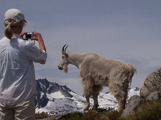
Condition Update: June 18, 2008. Reported by Tina Rieman. The road up was fine. No better or worse than usual, with just one tree to drive under that may come down on the road eventually. There were a couple patches of snow near the saddle (the dogs loved that), and lots of snow looking over toward the Enchantments. The main attraction was a friendly billy goat that hung around for the whole time we were having lunch. The Balsam Root is past it’s prime but there are tons of other flowers. The weather was cool, sunny, and breezy. Wedge Mt. is such a great hike. I never get tired of it, although it seems to me they’ve tilted the trail a little more since last time.
Leave It Better Than You found It: This should be every outdoor user’s goal. Pick up trash others have left behind, pull noxious weeds along your route, disperse fire rings found at campsites (they encourage more fires), throw logs and branches over spur trails and spurs between switchbacks (make it harder to do the wrong thing than the right thing).
IMPORTANT DISCLAIMER: Treat this information as recommendations, not gospel. Things change and those contributing these reports are volunteers–they may make mistakes, fail to give complete information, or may not know all the issues affecting a route. So forget about finger pointing: If things go wrong, you are completely responsible for yourself and your actions. If you can’t live with that, you are prohibited from using our information.
