Photo: Low-angle skiing near the top of Wedge Mountain
The weekend ridge loop has been planned for a month. We’ve all cleared the work calendars and played family politics to free up the time but, as Saturday approaches, the stars and aspirations are not aligning. Saturday is predicted to be showery and both weekend days will have considerable avalanche hazard. Pulling the plug is so hard — especially because of the different schedules we all keep, we may not find another weekend this winter to tackle this tour.
Therein lies a big problem. Even for those of us with the credo “Ski today that which lets you ski again tomorrow,” it’s hard to wait patiently for good conditions after you’ve invested time and energy to a project. You lean toward saying ‘yes’ even when the gut is saying ‘no.’ Which is exactly when a quiver of interesting backup projects becomes a safety device for getting the Labrador retriever brain of skiers to chase a different stick.
On Friday I circulate an email. “Forecast and snow condition aren’t good — suggest we postpone the high loop for a weekend with better viz and lower hazard. Any interest in exploring the ridge system from the bottom of Mountain Home Road (1,400 feet) to the top of Wedge Mountain (6,800 feet)? Looks interesting and safe – good skinning going up, probably everything from powder to corn coming down.”
With a new bone to chew, none of my companions mind switching objectives.
Saturday morning we leave the bottom of Mountain Home Road just off Highway 97 at 7:30 a.m. Within a hundred yards, we split off the road and follow an east-facing ridge out of the low lands. The ridge has just enough snow that on this March date the occasional skinning over threads of pine needles has us stitching together patches of snow into a skiable quilt.

Photo below: Skinning and grinning at the bottom of the route.
By the 2,400 foot-level, the snow is plump enough not to worry about where we lay our track. At the 2,800-foot level, we intersect an old logging road where we play a game of follow-it-then-leave-it as we cut between its low-angle switchbacks.

Photo: Looking down into Snow Lakes from a point near the summit.
From the 4500-foot level, we follow an east-facing ridge up to divide between the headwaters of Allen Creek (our side) and Snow Creek (the precipitous far side). We hook left and meander up gentle slopes to a 6,800-foot summit. Many locals call this bump Wedge Mountain but whether or not this the ‘real’ Wedge Mountain is unsettled business — two miles northeast of us is a 5,800-foot bump along the same ridge system that the USGS topographic map identify as Wedge Mountain.

Photo: Touring through old burns slightly below the summit.
The day’s soupy weather and the amount of new snow sitting on an old crust confirm that canceling our original plans was a good decision. Meanwhile, the descent off Wedge reinforces us for that decision. For nearly 2,000 vertical feet, we ski snow that Rocky Mountain skiers might disdain for its weight and moisture content but that carves easily beneath skis. For another 1000 vertical feet, we cut through snow that is so wet it lets you experience slow motion in real time — the skis simply move through all the mass and all the moisture s-l-o-w-l-y. Next, we’re into slurpy snow that’s more water than ice and finally it gives way to crusty old snow that, because it’s warm today, has a soft skin of corn.

Two photos: It may not be blower powder, but squirty powder will do.

Our final 1000 vertical feet of skiing is arguably the most entertaining as we round-off turns on both sides of a narrow ridge whiskered with orange-barked ponderosas. We follow threads of snow that dissolve into plots of pine needles. Then, leaning back on the tails of our skis, we skim over 10 or 20 feet of needle-covered duff leading to the next patch of snow. It’s corn skiing spiced with pine needles, and the novelty of it makes us laugh. Three hundred vertical feet from Mountain Home Road there’s too much rock in the mix to keep skiing. We pop off the boards, throw them over shoulders, and in five minutes we’re back at the car.
None of us gripe about what we gave up today. With a good backup plan (and our region offers many alternatives like Wedge), you don’t feel cheated when the dog brain is asked to fetch a different stick.

Photo below: Looking down on Highway 97 from about the 4,100-foot level.
Details, Details: Wedge Mountain
Activity: Backcountry skiing or snowshoeing. The above account is written from a skiing perspective but this route is very conducive to showshoeing as well.
Skill Level: Skiing: 2. Snowshoeing: 2. Note: Reasonable route finding skills are needed to stay on course and to travel this route efficiently (keep a compass and altimeter handy).
Fitness Level: 3. Even if your fitness level is below what is needed to make the top, following this route up as far as time and energy allows is a fun exercise. Views open up and get quite expansive from the 4,100-foot level and above.
Elevation Gain: 5,500 vertical feet. A bit more than a vertical mile!
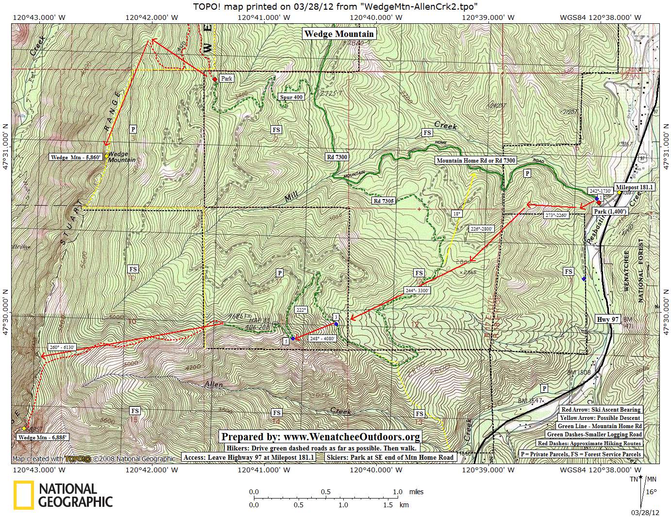
Access. From the Y Junction a few miles east of Leavenworth, drive about 4 miles south on Highway 97. At milepost 181.1, turn right (west) at the Mountain Home Road turn off. Follow the paved road for 150 to 200 yards. Mountain Home Road takes off on your right (unplowed in winter). Park here – no permits required. Note: Snowmobilers who use Mountain Home Road park here in winter as well. Park your vehicle on the very fringe of the intersection of the plowed and unplowed road so that those towing trailers can maneuver without denting your vehicle.
Map. See our topo map of this route below.
Trip Instructions:
- Start up Mountain Home Road. Within 100 yards, branch to the left and access the small ridge intersecting the road.
- Follow this NE- to east-facing ridge to the 2800-foot level. Depending on the time of year, you may need to walk the lower portion of the ridge up to snow level.
- At the 2,800 foot level, trend west and hit an old logging road. Follow the logging road (very flat in this area) in a southwesterly direction for about half a mile. When the road makes a noticeable hook to the south at a small creek (2,900 feet), leave the road and keep traveling cross country on a southwesterly bearing (244 degrees, true bearing) until you reconnect with the road at 3,300-foot level.
- At the 3,300-foot level of the road, find a prominent open slope above the road heading uphill and climb this slope along a bearing of 248 degrees until you reconnect with the road again a 4,080-foot level. The road switchbacks on a prominent ridge at this elevation.
- Follow the road for about half a mile to the 4,500-foot level. The road ends here.
- Keep on the ridge before you and follow a bearing of 260 degrees until you reach the spectacular divide separating Allen Creek (your side of the divide) from Snow Creek (far side of the divide). Turn left and follow a bearing of 192 degrees up to the summit. There are various bumps along the ridge at an elevation of 6,700 to 6,800 feet that you may want to call your highpoint.
The Descent. Start by following the ascent route down. Along the various ridge systems you’ve followed to the summit, there are small climbs and flat spots that, through good track setting on the way up, you can glide rapidly across on the return. Some of the road skiing on the return is flat but shouldn’t require your skins. Back at the point where you first intersected the road on the climb (2,800-foot level) we found it easier to re-apply skins as we worked our way back to the initial ridge system climbing above Mountain Home Road. From this same point on the road, however, you may be able to ski in a northerly direction directly down to Mountain Home Road and then follow Mountain Home Road downhill for a mile to the start (see the yellow arrow on our map). This might be the fastest route for the return, but we don’t know if the forest here is friendly (open) or fierce (thick).
Reporter (and date). Posted by Andy Dappen on 3/07/2012.
Leave It Better Than You found It: This should be every outdoor user’s goal. Pick up trash others have left behind, pull noxious weeds along your route, disperse fire rings found at campsites (they encourage more fires), throw logs and branches over spur trails and spurs between switchbacks (make it harder to do the wrong thing than the right thing).
IMPORTANT DISCLAIMER: Treat this information as recommendations, not gospel. Things change and those contributing these reports are volunteers–they may make mistakes, fail to give complete information, or may not know all the issues affecting a route. So forget about finger pointing: If things go wrong, you are completely responsible for yourself and your actions. If you can’t live with that, you are prohibited from using our information.